Total Distance: 13 km
Return Time: 6 hours
Elevation Gain: 966 m
Difficulty: Difficult
Region: Kluane
Traditional Territory: CAFN
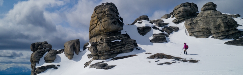
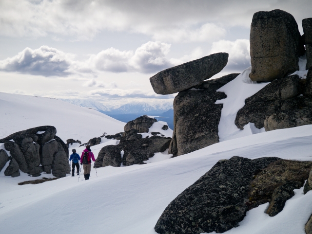
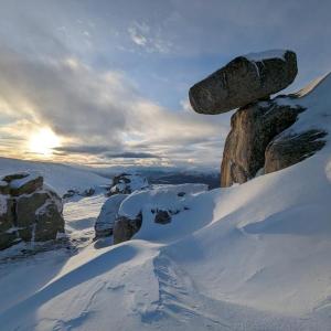
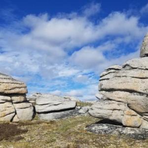
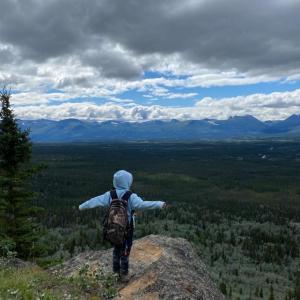
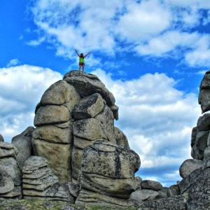
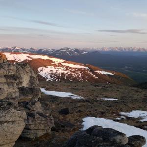
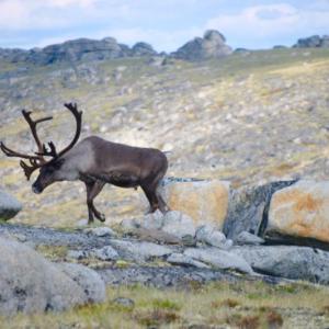
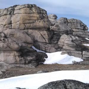
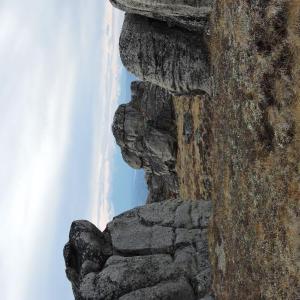
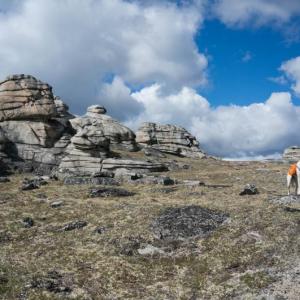
This route takes you to the top of a mountain plateau dotted with impressive rock formations that make you feel like you're in another world. A tor is a prominent rock or pile of rocks on top of a hill, and the tors on this hike offer lots of exploring or even bouldering opportunities if you're into that kind of thing. There are also great views of the Kluane Front Ranges towards Haines Junction and the Aishihik and Dezedeash River valleys. Note Dall sheep can often be seen in the area. NOTE: This hike falls within Category B Settlement Lands of the Champagne & Aishihik First Nation. Please respect their rules and land.
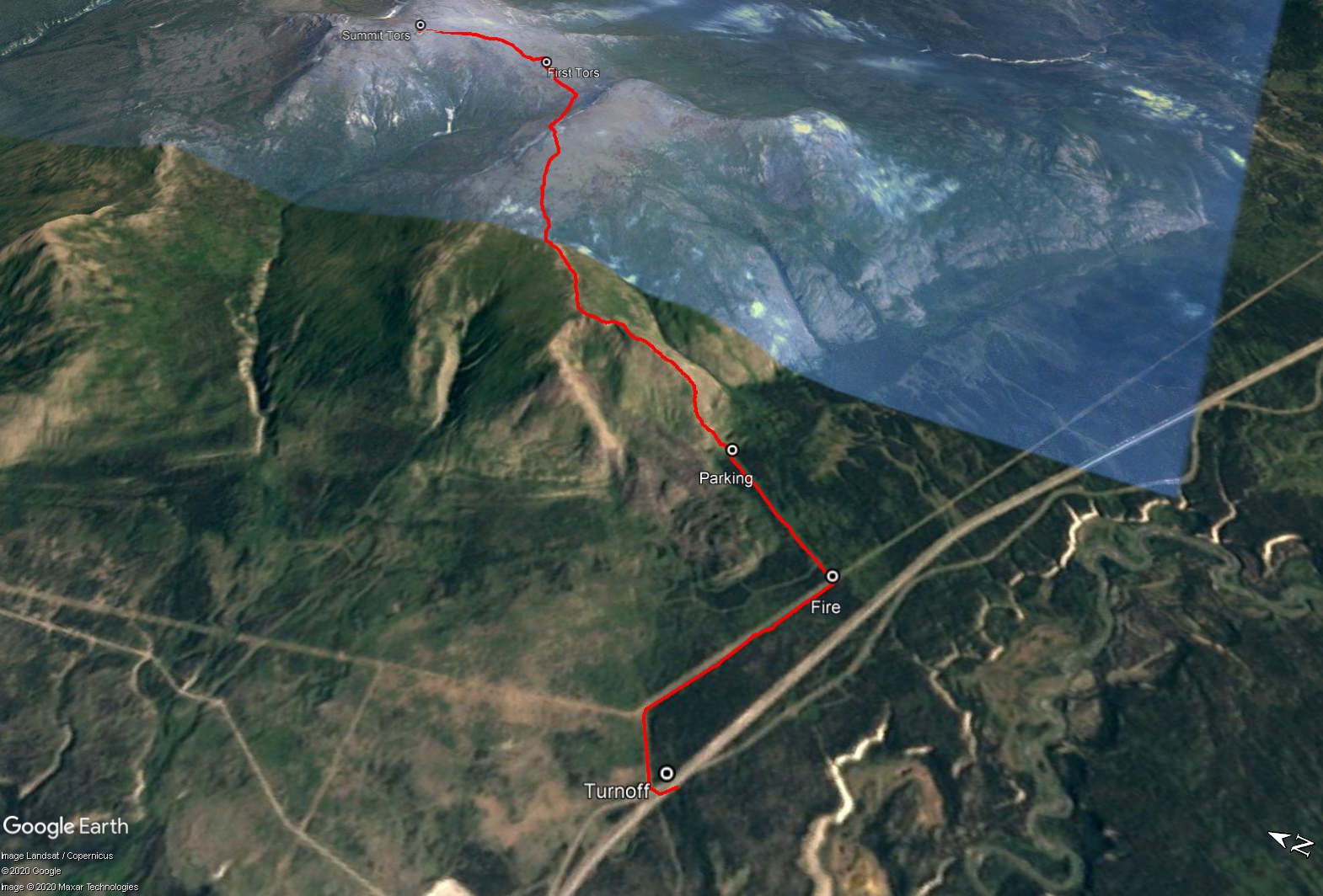
From Whitehorse take the Alaska Highway north towards Haines Junction. After 121 km and just before the Otter Falls Cutoff (Aishihik Lake Road) turn off the highway onto a gravel road on the right before a white sign for the Otter Falls Cutoff Gas Station.
Take the first right on the gravel road heading northeast towards the transmission line (parallel to the highway). Follow the transmission line to the right for approximately 2 km until you reach an obscure fire break on your left (line of aspen trees between the spruce) that heads directly towards the mountain. The fire break may not be obvious at first, so make sure to keep an eye out for it.
Follow this road to the end and park at the base of the mountain. If there are any obstacles, like fallen trees, you may have to walk these roads, so plan accordingly (potentially adding an extra hour or so). Also, after periods of rain, this road may be too muddy to drive.
Note: This hike is not within Kluane National Park & Reserve.
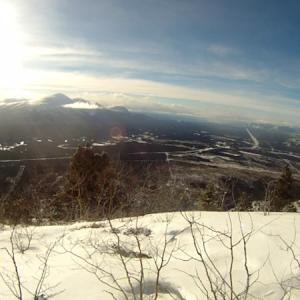
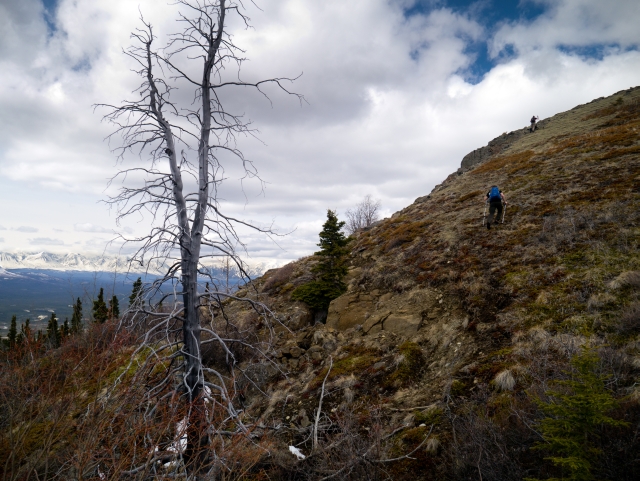
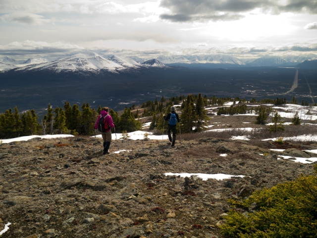
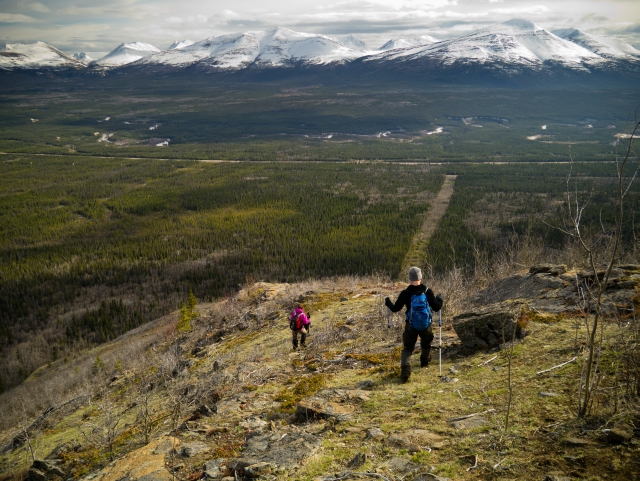
From the trailhead, follow the ATV trail that heads straight up the hill. This trail eventually narrows into a nice single track hiking trail that you can follow up the rocky ridge. Higher up the ridge, the trail does branch into multiple options, but the best route is to stay high on top of the ridge. Other options are to follow the vague sheep trails on the right (east side of the ridge) but these become very steep and overgrown. Near the top of the rocky ridge there is a small grassy knoll that is a nice place for a break with good views towards the peaks of Kluane.
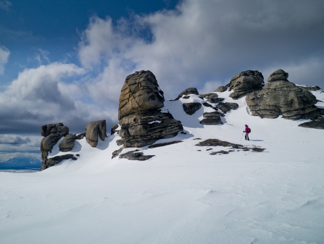
From here, the route opens up along a wide ridge. Continue along the ridge as you gain access to the subalpine. Pick up a light trail that leads through the brush and sparse trees, making your way towards the broad, open alpine slope above you. Climb the open slope towards the ridge top, aiming towards the middle, left of the ridge. Once on the top of the ridge you will see several groups of tors to the north. You will need to drop down slightly from this first ridge and contour around to gain access to the tors on the next ridge.
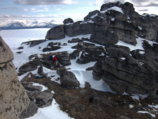
The first group of tors are just up from the saddle between the two ridges. There is a larger, more impressive group of tors towards the summit of the alpine plateau to the left (northwest). There are lots of opportunities for exploring and discovering every nook and cranny of these impressive rock formations. Return the way you came up.
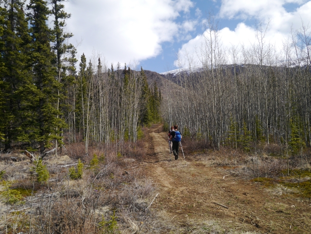
Walking along the fire break road. The trailhead is at the end of this road, which you can drive to if you have a vehicle with a little clearance.
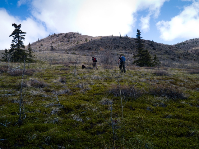
From the trailhead, hike up the somewhat steep slope, making your way up and over the rocky ridge.
Climbing towards the grassy knoll near the top of the rocky ridge.
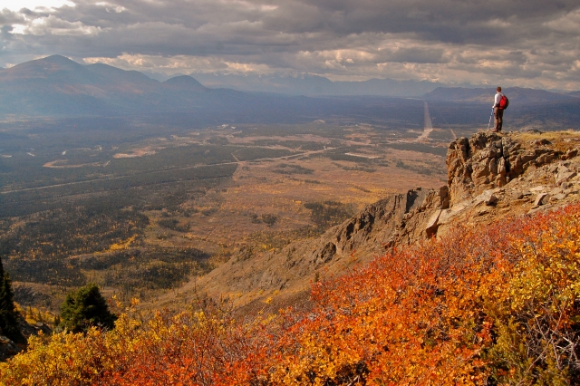
A nice lookout spot along the way - great colours in the fall.
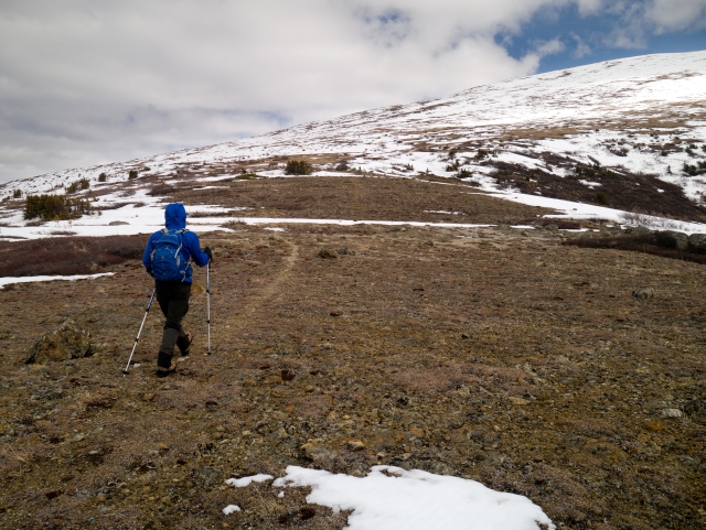
Following a vague sheep trail towards the broad, open slope.
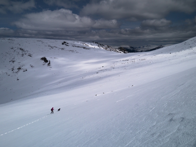
Descending from the first ridge towards the saddle and the tor ridge.
Exploring the neat arrangement of rocks at the first group of tors.
Approaching the second group of tors near the summit of the alpine plateau.
The tors at the summit make for a great shelter for lunch or a snack.
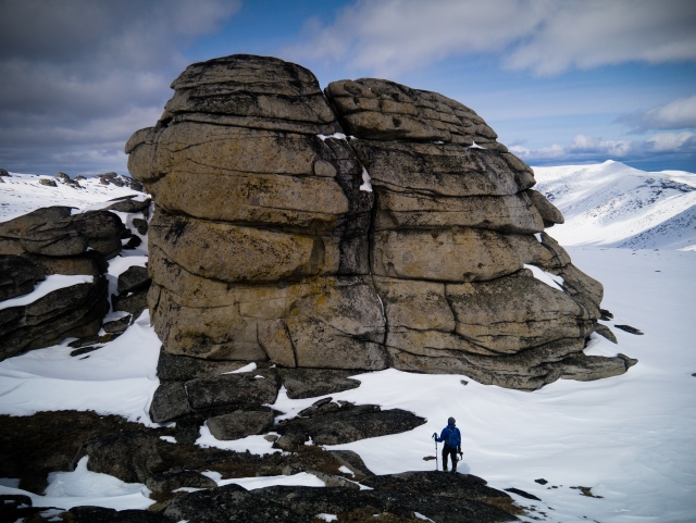
The rock formations are the most impressive from close up, and you'll wish you brought your rock shoes to try some bouldering.
Walking back down, through the subalpine trees, with nice views towards Kluane and the Dezedeash River valley.
Descending the rocky ridge, with the fire break below.
Liam G July 24, 2025
Hikes The Tors today 24 July 2025. Access road muddy and deeply rutted. Ford Explorer bottomed out a couple times. Ended up parking at the powerlines. Total time 5.5 hours and 17km round trip from there. Trail condition great.
Kevin Rumsey June 25, 2025
Thanks, Denise. I've been eyeing this one for awhile! Going to happen soon.
Denise June 23, 2025
Hiked the Tors today, Jun 23rd. Conditions were excellent. Was able to drive my Rav4 all the way through the firebreak without issue. First 350m of elevation gain is very steep, then it becomes a fare bit more gradual. Saw 5 caribou near the first group of Tors. Alpine flowers blooming everywhere!There would be lots more room to explore up there if camping. Beautiful hike!!

David May 12, 2025
We were up here on May 11th. The road was dry and fine to drive as long as you've got good clearance on your vehicle. At least until the next big rain. The trail was pretty much snow free up to the alpine, where there was patchy snow. We didn't get up that high due to sheep on the ridge, but it looked easy enough to find dry ground to hike up as far as the first ridge at least.
Katie July 21, 2024
Hi Denny, I have found your red travel mug. I posted on the Happy hikers Yukon Facebook page - DM me to coordinate pickup
Whitehorse July 21, 2024
Someone found your red mug

Denny July 19, 2024
Hiked on July 18, 2024 but lost my favourite red travel mug somewhere in the alpine before the tors. Please comment if found.
Sarah A June 9, 2023
i can confirm there is cell service 95% of the time if you were curious. Driving to the last parking lot is a nightmare. I dont know if ever gets better but some muddy parts. Park by the powerline to be on the safe side! There is some water source close to the saddle ( melted snow ) so you can refill on a hot day but not sure if this is available in the summer! Mostly snow free!! Happy hiking
Will April 5, 2023
Such a fun, unique hike - did this in mid-February 2023. Ski-in along the road and firebreak to shave tons of time, then snowshoed up from the clearing at the end of the firebreak. Quite a leg workout all the way up! Also extremely windy the whole time, absolutely barren and no wind shelter at all so make sure you bring a good shell and things to cover your face if you are doing it in the winter!
Deb August 21, 2022
Hiked the Tors yesterday. Tried to drive in on the last access road but turned around and parked at the fire break. Big ruts and some mud. Started at 11 and got back to the car at 8:30. Maybe 2 hours of breaks. Expect a full day. We had spectacular weather. No wildlife but some ladies had been camping up there so that's probably why.
Sharina July 24, 2022
Beautiful day for this hike!
Access road was deeply rutted but dry and passable with a truck. We parked at the entrance to the fire break and walked in with a MILLION mosquitoes.. but as soon as we got out of the trees and into the wind we left them behind.
A pair of black bears were hanging out in the fire break all day… perhaps feeding on wild strawberries and soapberries…? But we also caught a whiff of something funky in the air so not sure if there was maybe a carcass also?
Sharina July 23, 2022
Beautiful day for this hike!
Access road was deeply rutted but dry and passable with a truck. We parked at the entrance to the fire break and walked in with a MILLION mosquitoes.. but as soon as we got out of the trees and into the wind we left them behind.
A pair of black bears were hanging out in the fire break all day… perhaps feeding on wild strawberries and soapberries…? But we also caught a whiff of something funky in the air so not sure if there was maybe a carcass also?
Leigh June 24, 2022
Attempted today, got stuck in mud ~300m down the access road. We were driving a 4x4 SUV. Tow trucks will not come down this road, thankfully some kind passers by pulled us out! Would recommend parking just off the highway and walking in.
noah May 11, 2022
I'm planning on doing the tors in a week or so, does anyone know the snow levels right now?
Heather October 24, 2021
Tried to do the trail on Oct 24th, unfortunately got our Escape stuck about 2/3 of the way up the fire break road 😭. Just too wet in spots and not enough clearance. Thankfully got rescued by a friendly local with a pickup truck as the tow truck companies do not want to go out there! Suggest parking at the start of the fire break road and hiking in to avoid our error.
Marianna July 19, 2021
We hiked The Tors, also known Castle Rocks on Jul 18, 2021, 9 hours, 21 km, 1533m elevation gain. We took lots of time to explore and take pictures. The fire clearing road was way too muddy to drive to the base of the mountain and the mosquitoes on this section was apocalyptic. Trail is not easy to find to cross over to the mountain with the Tors. Marvellous rock formations, lots of bouldering space. A caribou galloped by very close to us. Lots of gorgeous alpine flowers.
PL - July 10, 2021 July 14, 2021
Parked in at the power lines, but then walked through to the start of the trail, there were a crazy amount of Mosquitos, so we practically ran through the trail and even at the beginning of the hike up the mountain we were rushing to get out of the mosquitos. The view at the top is great, still was quite a bit of snow, we only made it to the mountain across from the Tors, as it took us 3 hours to get to that point and the clouds were not looking very happy and did want to try getting down in the rain on the rocks. Packed something warm for the top with the wind it was probably about -2.
LNG June 22, 2021
I hiked it last weekend. Some ice patches at the top, but doable. 4x4 required to get to the trailhead. Great views, completely worth it.
WW June 22, 2021
Hiked the Tors this weekend and thoroughly enjoyed the trail.
We drove in as far as the power lines but decided to leave our cars there and hike in the rest of the way, as the road was manageable but deeply rutted and muddy. The road to the parking lot is in similar condition and would likely be passable with a 4x4 with sufficient clearance but is quite muddy with some deep puddles. However, the mosquitos were terrible along the powerlines and cutline, so if bugs aren't your thing and you have a decent vehicle, it might be worth pushing it.
The trail itself is in good condition and is easy enough to follow as long as you keep your eye out for rock cairns and orange flagging tape. After the ATV trail ends, It's important to keep to the left and follow the ridgeline as you hike (some very light scrambling along the ridge), otherwise you'll end up deeper in the eastern valley and either have to climb back up, or end up on the wrong ridge. Eventually you'll pop out above the deciduous trees and into a small meadow with conifers (great lunch location!). The trail is easy to follow as it winds through this meadow and eventually you'll reach the end of the tree line and be in alpine tundra. At this point, we hiked to the west around the base of the hill before heading north towards the Tors (at this point you can clearly see the first set, so pathfinding is simple). There are sparse snow patches on this north-west facing slope, but they're easy enough to avoid and keep your feet dry.
All in all it was a fantastic hike with a beautiful landscape. Highly recommend it!
CL June 12, 2021
Anyone hiked it this spring/summer?
Terri August 1, 2020
How does this trail compare to King's Throne in terms of level of difficulty? Both are rated as 'difficult' but just enquiring. King's Throne wasn't so bad.
MM July 29, 2020
What video?
Stella July 6, 2020
Hiked this yesterday and it took 7 hours out and back. Got lost for a bit early on and had to backtrack slightly to avoid the goat trails that skirt the shoulder to the right. There are some stacked stones to look for as you are hiking up if you lose the trail and also at one point the trail has a fork that is easy to miss as the left fork just looks like some dirt and rocks that you need to climb. It was quite steep for the first 1/3rd of the hike but still manageable. The trail comes and goes later on so it was good that we had studied where to go and printed our map beforehand. Once you skirt left below the first peak you can clearly see the Tors and it’s academic after that.
Road was ok with some ruts and mud, but another group managed to get to the trailhead in a small sedan. Some snow near the first peak but easily avoidable.
Saw a what I think was a Hoary Marmot on top of the tors but not much else other than some furry scat from a smaller carnivore of some type like a coyote or wolverine or such.
Isabelle June 17, 2020
We tried to get to the trailhead this morning but couldn’t drive the trail under the transmission line. We were driving a Pathfinder and we bottomed up in a mud puddle. It has been rainy quite a bit in
Haines Junction area. I would definitely wait couple weeks so it dries out. We had a chat with the cashier at Otter Falls Truck Stop and she said someone got stuck on that road last week too... We changed our plans and headed to a different trail for the day.
JP June 7, 2020
We were up at the Tors the same weekend as the previous poster. That video is great. It will help anyone doing this hike for the first time understand the approach options.
But after two previous visits, I'm convinced that heading to the top of the first peak is the best way to go.
From that peak you look down on the saddle which leads to the rock formations on the other side of the valley. Dropping down to the saddle from there may look intimidating, but it is much less steep than it looks and the footing is very secure. It took us about 10 minutes to get down to the saddle.
And the way is clear. There's no snow between the peak and the saddle.
From the saddle you're maybe 15 minutes to the first set of Tors.
I like this route because the gradual rise along the ridge and the grassy alpine tundra make for easy and exhilarating walking. From the top you get great views of the several clusters of Tors and of the surrounding area.
Enjoy the Tors they are truly amazing.
Jennifer May 25, 2020
Hiked this the 3rd week of May, though we never actually reached the Tors. We ended up on the wrong peak and ran out of time to backtrack and cross over. There were several other groups who made the same mistake as us, so I made a short video in hopes of helping others avoid our mistakes! www.youtube.com/watch?v=8sCkRH77UFI
Brittany September 1, 2018
An easier way to access the trailhead is by going 106.85km from the intersection of the Alaska Hwy and the Klondike Hwy. There you will find a small flagged access dirt road on the right that leads to the power line. I would suggest parking your vehicle there. From there, turn left on the powerline, walk a few hundred metres, then take your first right which is the trail through 'firebreak' (aspens on your right, evergreens on your left).
Paul Mantle August 1, 2018
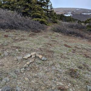
Did the hike last weekend to the first set of tors taking 7 hours round trip. Partway up the steep trail at the beginning you will see a few pieces of blue flagging going up a rock pile, even though the main trail continues to the right. The right trail eventually peters out into goat trails and we ended up doing 100 meters of bushwhacking at the end to intercept the main trail. If you follow the blue flagging instead, you will scramble up a couple of rock piles with mini inukshucks showing the way. This is how we came back down. Long hike but worth it.
Cristina Ramos July 23, 2018
We hike the Tors yesterday.
Beautiful and warm day and beautiful hike although we lost the trail a few times.
We were very lucky spotting wildlife, we saw a black bear in the beginning of the trail but he was kinda far, a lonely sheep at the top, a sleepy marmot that freaked out and yelled at us, many ground squirrels and a gorgeous caribou that came from very far to check us out.
The mosquitos were insane! I recommend bringing a good repellent and also a lot of water and food.
The hike is doable in 5-6 hours but it took us 8. We spent a few hours at the top exploring the Tors and enjoying the views.
Shailyn July 14, 2018
Hiked the Tors with a friend today. My 94 Corolla made it to all the way to the trailhead (slowly), with only minor scratches from brush on the side of the road.
Lots of mosquito at the start of the trail, but lost them as soon as we started going up. We did the hike in 6 hours, stopping for lunch and a bunch of exploring at the top. It was quite windy today, but we still explored for a good hour.
We climbed higher up over the mountain for the way back, which made it easier to spot the trail below, and was much easier on our legs.
Saw some eagles, ground squirrels, heard two pika, and saw two other hikers.
Fantastic day that ended with a burger at the Otter Falls gas station. Tors continues to be one of my favourite hikes. It is truly magical up there.
Tim July 1, 2018
Were doing this on Tuesday 3 2018. Meet at Otter Falls Cutoff at 8am. Ask for Wally or Tim. tschooley69@gmail.com. There are 3 of us so far and. a dawg. We are all amateur. Weather prevailing. Have a good one!!!
Cata June 23, 2018
Hiked the Tors on June 21st with my dog Nootka. Beautiful sunny say, low wind. Lost the trail a couple of times but backtracked and found it.
There is so much to explore up there, will be going for a night in the next couple of weeks.
Sarah June 22, 2018
Three of us hiked this trail on June 19, a beautiful sunny day. We had a little trouble finding the final road that turns left and leads to the base of the mountain because it is actually 1.5km after the right hand turn to follow under the transmission line, not 2km. We were in a Ford Escape which had just enough clearance for the road.
There were a lot of mosquitoes at the trailhead but as we climbed they were no match for the very strong wind. We spotted some caribou in the alpine and veered to the right to give them some space. We may have been too far to the right as we made it to the mountain top but were not close to the Tors. We saw some from a distance. There are game trails and hikers can quickly see far and wide. It was unusually warm for our descent (27C). Our hike took 5.5 hours return. Beautiful views.
Crystal May 27, 2018
Hiked the Tors this weekend. Trail was in great shaped (although we lost the trail a couple times and just made our own path up!). There were a few snow patches to hike over as we approached the Tors, but the snow was (for the most part) hard enough to stay on top of. It was sunny and hot for the first couple hours of the hike, but by the time we got to the tors about 3 hours later, it was pretty cold and unbelievably windy. Even snowed some. So be sure to pack some warm gear just in case if you plan to stay at the tors and explore a bit.
As for the drive in. We had a Subaru Forester type vehicle and a Chevy Cruze. The car could have made it the entire way had it not been for a deeply rutted mud patch. The Subaru made it through with a bit of encouragement.
We did the hike roundtrip in about 7.5 hours. But there were seven of us which sometimes made for lots of stopping for pics and water and food. We also spent a chunk of time at the tors. We also lost some time when we lost the path near the top and had to bushwhack when we should have been in the open alpine. We found the path we missed on the way down. There is no bushwhacking on this hike, and if you are doing it, backtrack and find the path you missed!
Jackie May 26, 2018
Climbed with a group May 26. Two trees have fallen across the road leading to the trailhead - one is small enough to drive over, and the other is quite large but there's space to drive around it. There was a large mud rut shortly after that was doable with an AWD Subaru, but that we didn't dare risk with a regular sedan. Rest of the way to the trailhead was also fine with the Subaru.
Trail itself was in good condition. There's an inukshuk after the first kilometre or so - follow the path to the left when you see that. In the grassy knoll mentioned above, we found there were two paths we could take. We took the one to the left - BIG mistake. It was okay for a few hundred metres but then forced as to bushwhack to get into the subalpine. We took the other path on the way down - a much clearer, easier route to follow. We built a rock arrow (pic attached) to point out the better route for future travellers.
Once we got into the apline, we hiked up and to the west. Once we crested the ridge, we could see the Tors. There's no more paths up here, but once we saw them, it wasn't hard to see how to get over to them.
There was still some areas covered in snow in the alpine area leading to the Tors which was prone to collapsing when being walked on. Be prepared for your foot to suddenly sink down to the knee while walking across these patches. It snowed quite a bit while we were there and as we were leaving so conditions may be worse now.
Wildlife sightings included lots of goats (some of which were on the path, although quite a distance from us), a chipmunk and a ptarmigan. Heard a lot of pika but didn't see any of them. Also saw quite a few bear prints and poop but no direct sighting. Lots of wildflowers and interesting lichens.
Took us 8 hours roundtrip from the trailhead to the first set of Tors, including breaks for lunch, snacks, photos, etc. We didn't get to the second set because it started to snow and the wind was really picking up after we made it to the first ones.
Kate May 20, 2018
Hiked up the Tors this weekend - the trail was great. It was slightly spongy as you got into the alpine, but it was barely noticeable and the rest of the trail was bone dry. We peeked over the backside once we got to the top and elected to go up to the summit rather than head over to the tors themselves - there was still quite a bit of snow on the backside and we knew that there were a lot of rocks under the rotten snow- didn't want to risk rolled ankles.
As for the drive in, we had a 4x4 capable vehicle with lots of ground clearance (Jeep Grand Cherokee) and had no trouble at all. That said, the trail in was pretty rutted, there were a couple of trees lying over the trail and there was one stretch of mud maybe 2-3 m long. I wouldn't have been comfortable trying it in much less than what we had.
Wildlife sightings included a porcupine, some distant sheep and an even more distant black bear. We were up and back in about 6 hours and it is one of my favourites.
Daniel May 8, 2018
Has anyone hiked the Tors trail lately?
Anne July 13, 2017
Is it possible/allowable to camp on or near this trail?
Gerald July 1, 2017
Did this one in May - an amazing day!
I do a lot of solo hiking, but if anyone is interested in doing some trails this summer, send me an email.
gergerry1234@gmail.com
Richelle Tumamang April 3, 2017
We plan to hike the mountain this summer but I've been talking to locals, inquiring about "The Tors". Apparently, they call it Castle Rock. I've heard good things about it so looking forward to hiking season!
Pat , Nikola October 17, 2016
Was an amazing hike up , Took us about 8 Hours up and back down to the Fire break parking lot . There was a couple cm's of snow up at the top that made it all glisten with the sun . Was a beautiful hike and can't wait to come back in the spring and stay the night .
Danielle September 20, 2016
Last week a friend and I hiked the Tors. We were able to drive to the base of the mountain in our jeep with no trouble however we did take the wrong road originally (if you are following the fence you are not on the fire break road). The first kilometre was very steep going with a fair bit of scrambling but after that things got easier. One mistake we made was that the ridge you start your hike from is not the one with the tors. We hiked almost to the peek so had to back track and cut across to the correct ridge. None the less, this was a stunning hike. The views were incredible, the Tors were definitely worth the hike. We only made it to the first set before we had to head back down. On the hike we saw sheep, a family of ptarmigan and a black bear (off in the distance).
Jo August 27, 2016
Got stuck in the mud within 100m after the first right on the gravel road. The road is deeply rutted and very slick. I would not recommend it unless you have a high clearance 4x4. Got bailed out by a nice guy from Haines & left my vehicle right at Aishihik turnoff along the highway. Trail is pretty good all the way to the first plateau from where it peters out in the spongy meadows. You can contour around the first peak but I thought travel was a bit faster and the view was great staying on the ridge on the way back although you do add some elevation. I ended up scaring a group of dall sheep all the way to the 2nd group of tors from which I was hoping to continue further on the ridge but decided to leave the sheep alone. Met a party of 4 on their way up on my way down and they had parked on the highway to intersect directly with the transmission line & fire break roads. This is definitely the way to go to avoid the sketchy bit of road in the driving directions. It will add minimum distance as opposed to walking the road like I did. If you chose that option, park at UTM 392522 6747135 and head for the intersection of the transmission line and firebreak at UTM 392368 6747554. Anybody can explain the tors formation in some details? Cheers!
Nicola July 14, 2016
We did this hike on July 3. Made the same mistake as the hiker below and missed the scramble to the rocky ridge and instead traversed the right hand hill on a game trail. Watch for the trail heading up the rocks on your way up as it is easy to miss! Came across some decent streams while traversing the far side of the first ridge. The Tors are really fun to explore, and the surrounding ridges from the second set of tors looked so inviting, if we had had the time. This could easily be turned into an overnight trip - tent at the tors and explore the surrounding alpine in any direction.
Susan June 26, 2016
Hiked into the Tors on June 25th. It was a terrific hike with a bit of snow and melt water for the dogs closer to the area of the Tors. The difficult rating seems to relate more to the trip length than the demands of the terrain. When we hiked out, we came across a clearer route down (although our route up did the job). From the parking spot (easily accessed with Subaru Forester), follow the ATV trail up the hillside. The ATV trail heads for the left side of the hill into an area of poplars, where you will come across a few hiking paths that will lead you up to the ridge for fairly open hiking. We did not ascend this way because instead of going into the poplars and finding a trail we went to the right of the ridge where it seemed more open, traversing the hill until eventually joining the trail on the top. So while we missed the trail on the way up, we did not have any problems and got to enjoy the trail on the way down.
Drew, Jason, Kristin September 23, 2015
Hiked the Tors on Sept. 19th.
A few notes about accessing the trailhead. We turned off the highway on the Aishihik Road directly across from the Otter Falls gas station. Take the first right (after the short bridge) and drive for about 1km (following the power lines) You will reach a fork in the road - stay to the right. Continue on the road for about 1.5km's until you pass through wooden gate posts and come perpendicular to another road. Turn left. Drive for about 1.5km's until you see an opportunity to turn left. Take this left turn and this road will take you to the trailhead. We drove a mini van with decent clearance and didn't have any issue getting almost all the way to the trailhead.
Trail is easy to follow until you get into the subalpine and then you can just pick your route to the summit. Snow was knee deep just before the saddle so we were forced to turn back before reaching the true summit. Great views looking west along the Alaska highway and north towards the mountains.
Saw a herd of about 50 sheep - were about to get very close before they took off.
Great hike, will definitely be back next summer.
Lolo September 11, 2015
We are going tomorrow and stay over night
Tom Luxemburger August 17, 2015
Hiked into the summit on August 16th, 2015. Between the great weather and start of fall colours, the entire hike was breathtaking. My GPS showed a 3,400 ft gain over less than 5 km. Definitely a thigh burn and not for someone who experiences vertigo (only in a few spots). The geology on this trek was mind boggling. I WILL be doing this one again! I did it as a day trip but will likely do it as an over-nighter next time.
Gemma June 22, 2015
We ventured up to The Tors this past weekend. (June 20-21, 2015). It was an amazing hike and I would definitely recommend it. We saw only one young Caribou just below the first set of Tors. There is also still quite a bit of water below the patches of snow.
We camped on the soft ground below the first set of Tors, but make sure you check out the second set. All beautiful <3
Jonathan June 14, 2015
As a party of 3 and two small dogs we overnighted here June 06,2015. There's a really nice grassy patch in the saddle below the first set of tors for camping. Water can be filtered out of little pools here and there. Perhaps these become scarcer later in the summer. It was great to have the time to visit the various sets of tors. We saw a group of 3 caribou. We had seen the group of 4 last summer, maybe one has been lost to hunters or predators. You could continue on open ridges to the north to the lake in the distance. Maybe farther beyond that. So this could be a nice 2 or 3 day hike. Maybe you could return by hiking down to moraine lake and leave a vehicle there to avoid doubling back. This would have to be researched I'm not sure what that road is like. Note that when driving into the tors at the beginning that short connector road that gets you to the powerline can indeed become really muddy. Last year it was too muddy after a rainfall but we were able to access the powerline from the aishihik road to get to the tors trail head - this was driving a 4x4 suv.Also, the peak that you walk around to get to the tors is actually well worth climbing. A surprisingly easy climb from that saddle beneath the first set of tors.
Travis June 15, 2014
Did this hike on June 14 with a group of 6. Like most hikes on this site I highly recommend it.
Though rated difficult, once you get over the first rocky ridge it's pretty easy walking. It is a long hike and you'll want to explore the tors, so I'd recommend planning 10 hours. We got up and down in 8 but having more time to wander around would have been nice.
Oddly, on the way back down we were approached by four caribou. We were in a group of 6, plus a dog and they kept approaching closer and closer until they were about 50-60 feet from us. They stared at us for a while, and then headed off. It was rather strange.
Travis June 2, 2014
Couple quick questions for anyone who has done this hike - how steep is the rocky ridge? Is it safe for a dog?
And is there camping potential up near the Tors? Access to water?
Cheers.
Chris Deering February 18, 2014
17-2-14
10cm snow depth, -10'c with flurries. 4x4 to the parking area at the base of the mountain.
2.5hrs to summit the front face with hiking boots and 2 sturdy sticks, gained 540m and made a warming fire. Yeh!
That was it for me as this was quite difficult and time was a factor having started a bit late.
Still rad but, awesome rock formations. Like petrified tree in layers, but they were rocks. Lovely views of the valley and the frozen river system.
Very hard decent taking an 1hr, steep and slippery (-2'c with sun melt). A rope and a 2nd person would have been nice in places.