Tombstone Territorial Park
Distance: 8 km
Elevation Gain: 772 m (2533 ft)
Time: 6 hours
Difficulty: Moderate
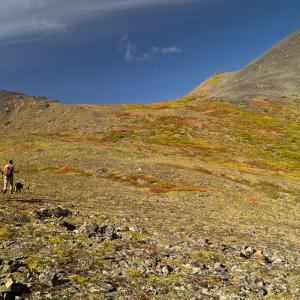
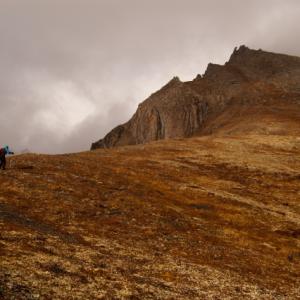
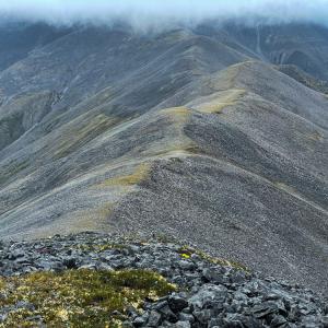
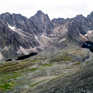
This route follows one of the many ridges that lead up to an open alpine plateau and a rocky ridge above two picturesque alpine lakes. There are often caribou on the plateau, and you get amazing views all the way up the ridge.
Elevation Gain: 772 m (2533 ft)
Time: 6 hours
Difficulty: Moderate
This route follows one of the many ridges that lead up to an open alpine plateau and a rocky ridge above two picturesque alpine lakes. There are often caribou on the plateau, and you get amazing views all the way up the ridge.
Distance: 6 km
Elevation Gain: 590 m (1936 ft)
Time: 3 hours
Difficulty: Moderate
This is a fun ridge walk up to Angelcomb Peak. It is short and offers great views up the East Blackstone River and the peaks and valleys to the east of the Dempster Highway. This area is important sheep habitat, and Yukon Parks discourages using this trail, especially during lambing season from May 15 to July 1st. Please drop by the Tombstone Interpretive Centre for more information about this sensitive area before you decide to hike it.

Distance: 21 km
Elevation Gain: 424 m (1391 ft)
Time: 6.5 hours
Difficulty: Easy
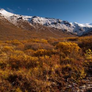
This route follows a horse trail along Foxy Creek and then up to the alpine plateau of Auston Pass in the Blackstone Range of Tombstone Territorial Park. This would be a long day hike to and from the pass, and it is better suited as an overnight/multi-day trip so that you can explore the area around the pass (see extended hiking options below). The views are stunning along the entire route. This pass is also used to access the Blackstone River Valley and Syenite Lakes to the south.
Consider avoiding this area during the hunting season, as it is popular with outfitters and local hunters, with gut piles resulting in more bear activity.
Elevation Gain: 424 m (1391 ft)
Time: 6.5 hours
Difficulty: Easy
This route follows a horse trail along Foxy Creek and then up to the alpine plateau of Auston Pass in the Blackstone Range of Tombstone Territorial Park. This would be a long day hike to and from the pass, and it is better suited as an overnight/multi-day trip so that you can explore the area around the pass (see extended hiking options below). The views are stunning along the entire route. This pass is also used to access the Blackstone River Valley and Syenite Lakes to the south.
Consider avoiding this area during the hunting season, as it is popular with outfitters and local hunters, with gut piles resulting in more bear activity.
Distance: 11 km
Elevation Gain: 663 m (2175 ft)
Time: 4 hours
Difficulty: Moderate
The ridge beside Charcoal Creek is one of the closest hikes to the Tombstone campground - it is right across the road. Charcoal Ridge itself is a very pleasant hike with sweeping views.
Elevation Gain: 663 m (2175 ft)
Time: 4 hours
Difficulty: Moderate
The ridge beside Charcoal Creek is one of the closest hikes to the Tombstone campground - it is right across the road. Charcoal Ridge itself is a very pleasant hike with sweeping views.
Distance: 6 km
Elevation Gain: 428 m (1404 ft)
Time: 3.5 hours
Difficulty: Difficult
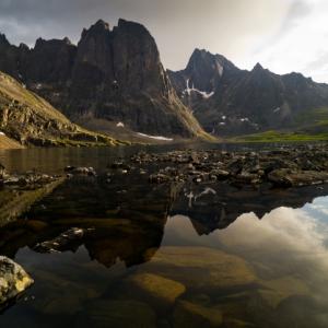
A beautiful backcountry camping destination where steep granite cliffs give way to the dark blue waters of Divide Lake (the headwaters of the North Klondike Valley). The route described here starts from Grizzly Lake and climbs up and over Glissade Pass (300 m elevation gain). Registration with Yukon Parks is required.
Elevation Gain: 428 m (1404 ft)
Time: 3.5 hours
Difficulty: Difficult
A beautiful backcountry camping destination where steep granite cliffs give way to the dark blue waters of Divide Lake (the headwaters of the North Klondike Valley). The route described here starts from Grizzly Lake and climbs up and over Glissade Pass (300 m elevation gain). Registration with Yukon Parks is required.
Distance: 7 km
Elevation Gain: 873 m (2864 ft)
Time: 4.5 hours
Difficulty: Difficult
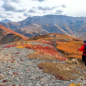
This long ridgewalk offers varied vistas, neat rock formations, and opens up many options for exploring the surrounding area. From the viewpoint up on the high ridges you get a birds-eye view of Alpine Lakes and Fold Lake. And if the weather permits you can even push on to the summit of Fold Mountain (1,973 m).
Elevation Gain: 873 m (2864 ft)
Time: 4.5 hours
Difficulty: Difficult
This long ridgewalk offers varied vistas, neat rock formations, and opens up many options for exploring the surrounding area. From the viewpoint up on the high ridges you get a birds-eye view of Alpine Lakes and Fold Lake. And if the weather permits you can even push on to the summit of Fold Mountain (1,973 m).
Distance: 4 km
Elevation Gain: 210 m (689 ft)
Time: 1.5 hours
Difficulty: Easy
This is one of the most popular trails in the park. It is close to the Tombstone Campground and is an easy walk that provides great views down along the Dempster Highway, the North Klondike Valley to Tombstone Mountain, and the mountains and ridges to the west.
Distance: 11 km
Elevation Gain: 797 m (2615 ft)
Time: 6 hours
Difficulty: Difficult
The route follows the well marked Grizzly Ridge Trail, traversing rocky talus slopes and beautiful alpine meadows, with ever improving views as you get closer to the lake and its entourage of rocky peaks. This hike is an overnight destination (permit required) or can be done as part of a multi-day trip including Divide and Talus Lake. There are also numerous side trips you can do from the lake, including Grizzly Pass and Mount Monolith / Twin Lakes viewpoint.
Distance: 5 km
Elevation Gain: 423 m (1388 ft)
Time: 2-3 hours
Difficulty: Moderate
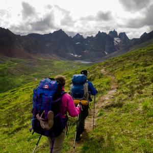
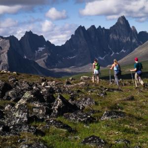
This is one of the most popular trails in Tombstone Territorial Park, and for good reason. Within an hour you get a view of Mount Monolith at the end of Grizzly Valley. The trail is well established, and you can continue along the ridge towards Grizzly Lake for as long as you like.
Elevation Gain: 423 m (1388 ft)
Time: 2-3 hours
Difficulty: Moderate
This is one of the most popular trails in Tombstone Territorial Park, and for good reason. Within an hour you get a view of Mount Monolith at the end of Grizzly Valley. The trail is well established, and you can continue along the ridge towards Grizzly Lake for as long as you like.

Distance: 11 km
Elevation Gain: 573 m (1880 ft)
Time: 5.5 hours
Difficulty: Moderate
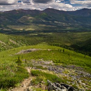
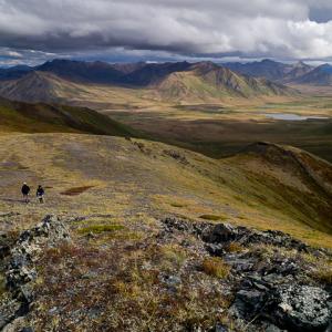
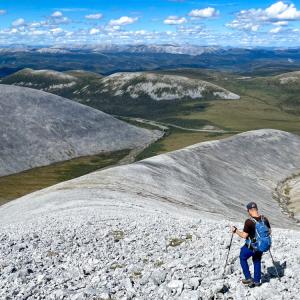
The route to Incline Mountain follows along the tops of an old moraine, which is the Continental Divide, all the way to the mountainside. Incline Mountain itself is part of the same Continental Divide as well. A steep ascent up the vegetated slope leads to a pleasant ridge walk to the summit. The views are outstanding. Bushwhacking is very minimal if you choose your route carefully.
Elevation Gain: 573 m (1880 ft)
Time: 5.5 hours
Difficulty: Moderate
The route to Incline Mountain follows along the tops of an old moraine, which is the Continental Divide, all the way to the mountainside. Incline Mountain itself is part of the same Continental Divide as well. A steep ascent up the vegetated slope leads to a pleasant ridge walk to the summit. The views are outstanding. Bushwhacking is very minimal if you choose your route carefully.
Distance: 7 km
Elevation Gain: 611 m (2005 ft)
Time: 3 hours
Difficulty: Moderate
This quick but steep hike off the Dempster Highway has beautiful views of the Blackstone River Valley and the amazing ridge system of the Distincta Peak area near Windy Pass. Note this hike is not within Tombstone Territorial Park, but could be a day trip from the Tombstone Campground.
Distance: 8 km
Elevation Gain: 630 m (2067 ft)
Time: 5.5 hours
Difficulty: Difficult
Mount Adney is a challenging and rewarding hike in the Blackstone Range in the Tombstone Area. This hiking route is to one of Mount Adney's rocky sub peaks with a magnificent 360 degree view.
Elevation Gain: 630 m (2067 ft)
Time: 5.5 hours
Difficulty: Difficult
Mount Adney is a challenging and rewarding hike in the Blackstone Range in the Tombstone Area. This hiking route is to one of Mount Adney's rocky sub peaks with a magnificent 360 degree view.
Distance: 7 km
Elevation Gain: 537 m (1762 ft)
Time: 3-4 hours
Difficulty: Moderate
A lesser known hiking route in Tombstone Territorial Park, but well worth the consideration. Mount Boyle is a hikers dream with mostly tundra walking the whole way. The route crosses a short section of tussocks, followed by a quick bushwack through willows and a leg-burning climb up to the ridge. The undulating rocky ridge is fun to hike, leading to a nice viewpoint of the peak. There is a further scramble to the actual summit of Mount Boyle if you want to add more distance and time.
Distance: 35 km
Elevation Gain: 340 m (1115 ft)
Time: 2-3 days
Difficulty: Moderate
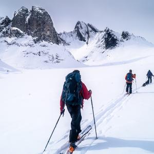
The winter route up the North Klondike Valley to Divide Lake is a great overnight ski trip within Tombstone Territorial Park. The route starts from the Tombstone Campground and follows along the frozen North Klondike River all the way to the lake. This route is best attempted in the late winter/early spring based on temperature, daylight hours and snow conditions. Also the valley is one of the few areas where snowmobile use is allowed in the park, therefore there is typically a packed trail to the lake, which makes the skiing a lot easier. Basic route finding skills are required.
Elevation Gain: 340 m (1115 ft)
Time: 2-3 days
Difficulty: Moderate
The winter route up the North Klondike Valley to Divide Lake is a great overnight ski trip within Tombstone Territorial Park. The route starts from the Tombstone Campground and follows along the frozen North Klondike River all the way to the lake. This route is best attempted in the late winter/early spring based on temperature, daylight hours and snow conditions. Also the valley is one of the few areas where snowmobile use is allowed in the park, therefore there is typically a packed trail to the lake, which makes the skiing a lot easier. Basic route finding skills are required.
Distance: 9 km
Elevation Gain: 751 m (2464 ft)
Time: 5.5 hours
Difficulty: Difficult
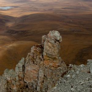
If crossing the Blackstone River doesn't deter you, then great views and interesting rock formations are your reward on top of Pilot's Peak. Tall rock columns are scattered around the summit, and the rounded grey ridges behind Pilot's Peak are spectacular.
Elevation Gain: 751 m (2464 ft)
Time: 5.5 hours
Difficulty: Difficult
If crossing the Blackstone River doesn't deter you, then great views and interesting rock formations are your reward on top of Pilot's Peak. Tall rock columns are scattered around the summit, and the rounded grey ridges behind Pilot's Peak are spectacular.
Distance: 7 km
Elevation Gain: 500 m (1640 ft)
Time: 4 hours
Difficulty: Moderate
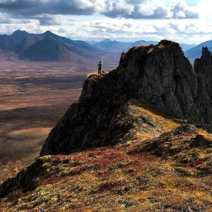
This gorgeous route in Tombstone Territorial Park lies just north of Mount Boyle and Mount Adney, and has the added benefit of a well-trodden horse trail to help you cross the tussock plateau. The hike up to the main ridge is steep but short and then it is a great ridge walk among the tors and rock spires with amazing views in every direction.
Elevation Gain: 500 m (1640 ft)
Time: 4 hours
Difficulty: Moderate
This gorgeous route in Tombstone Territorial Park lies just north of Mount Boyle and Mount Adney, and has the added benefit of a well-trodden horse trail to help you cross the tussock plateau. The hike up to the main ridge is steep but short and then it is a great ridge walk among the tors and rock spires with amazing views in every direction.
Distance: 8 km
Elevation Gain: 447 m (1467 ft)
Time: 3 hours
Difficulty: Easy
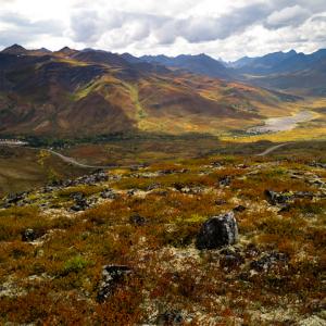
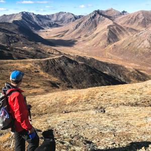
A nice tundra hike in the northern part of Tombstone Park in the Blackstone Range. The view includes the wide open valley of the Blackstone River as it meanders north and the surrounding rolling hills which give way to more dramatic mountain ranges beyond.
Elevation Gain: 447 m (1467 ft)
Time: 3 hours
Difficulty: Easy
A nice tundra hike in the northern part of Tombstone Park in the Blackstone Range. The view includes the wide open valley of the Blackstone River as it meanders north and the surrounding rolling hills which give way to more dramatic mountain ranges beyond.
Distance: 6 km
Elevation Gain: 133 m (436 ft)
Time: 2.5 hours
Difficulty: Easy
A trip to Grizzly and Divide lake is not complete without making it to Talus Lake as well. At Talus Lake you will finally get to admire the view of the iconic Tombstone Mountain as well as another side of Mount Monolith. The route described here starts from the Divide Lake campground with a gradual ascent over Tombstone Pass with stunning views of the Cloudy and Tombstone ranges on opposite sides of the valley. This hike can be completed as a day hike from Divide Lake if you're tired of carrying a heavy pack.
Distance: 5 km
Elevation Gain: 499 m (1637 ft)
Time: 3 hours
Difficulty: Moderate
This route is a short side trip from the Grizzly Lake backountry campground. It climbs to Grizzly Pass and then further up a ridge to a spectacular viewpoint of Mount Monolith with the Twin Lakes below. To complete this hike you will likely need to stay overnight at the Grizzly Lake campground (where registration is required).
Distance: 5 km
Elevation Gain: 519 m (1703 ft)
Time: 3 hours
Difficulty: Easy
This hike starts right at the top of Windy Pass on the Dempster Highway, so the elevation is high enough that there are almost no trees or bushes in your way. You follow a gentle limestone ridge up to a rocky summit with amazing views of the unique ridge system of Mount Distincta. Note this hike is not within Tombstone Territorial Park, but could be a day trip from the Tombstone Campground.