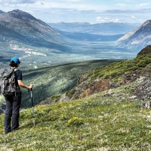
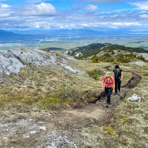
Whitehorse
Distance: 7 km
Elevation Gain: 323 m (1060 ft)
Time: 2.5 hours
Difficulty: Easy
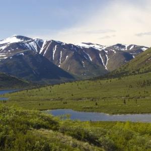
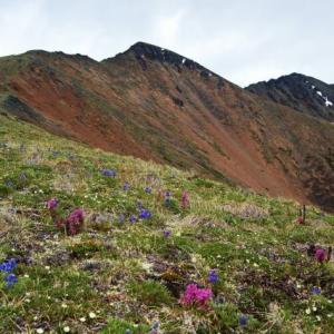
This trail starts at a high altitude and is so close to Whitehorse that you can get off work and be walking along a ridge in the alpine in no time. Once on the ridge, there are many options and ample opportunity for exploring.
NOTE: The Fish Lake area falls within Category A Settlement Lands of the Kwanlin Dun First Nation. Please respect their rules and land, particularly avoiding the area during the hunting season (which starts August 1st) between the hours of 5 pm and 10 am.
Elevation Gain: 323 m (1060 ft)
Time: 2.5 hours
Difficulty: Easy
This trail starts at a high altitude and is so close to Whitehorse that you can get off work and be walking along a ridge in the alpine in no time. Once on the ridge, there are many options and ample opportunity for exploring.
NOTE: The Fish Lake area falls within Category A Settlement Lands of the Kwanlin Dun First Nation. Please respect their rules and land, particularly avoiding the area during the hunting season (which starts August 1st) between the hours of 5 pm and 10 am.
Distance: 23 km
Elevation Gain: 891 m (2923 ft)
Time: 6.5 hours
Difficulty: Moderate
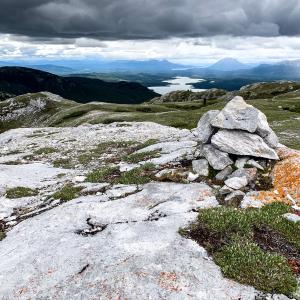
Golden Horn overlooks Whitehorse and is located behind Mount Sima, the local ski hill. Interestingly the Southern Tutchone name for Golden Horn, is 'Sima' and translates to 'red ochre'. The trail follows the Coal Lake Road up to an ATV trail which leads to the mountain. The views from the top are beautiful- you are overlooking Whitehorse, Lake Laberge, and all the mountains and lakes in the valley towards Carcross.
Elevation Gain: 891 m (2923 ft)
Time: 6.5 hours
Difficulty: Moderate
Golden Horn overlooks Whitehorse and is located behind Mount Sima, the local ski hill. Interestingly the Southern Tutchone name for Golden Horn, is 'Sima' and translates to 'red ochre'. The trail follows the Coal Lake Road up to an ATV trail which leads to the mountain. The views from the top are beautiful- you are overlooking Whitehorse, Lake Laberge, and all the mountains and lakes in the valley towards Carcross.
Distance: 5 km
Elevation Gain: 200 m (656 ft)
Time: 2 hours
Difficulty: Easy
The Southern Tutchone name for Grey Mountain, The May, refers to to the grey-white colour of the rocks. Grey Mountain is a great day hike offering a terrific view of Whitehorse and the surrounding area. You can see from Marsh Lake in the south to Lake Laberge in the north. The trailhead starts only 200 m lower than the summit, which means more alpine walking. It's only 2.5 km to the summit, which is a good turn around point if you don't want to continue walking the ridge.
Distance: 9 km
Elevation Gain: 938 m (3077 ft)
Time: 5 hours
Difficulty: Moderate
This is a challenging hike in the Ibex Valley up to a ridge with dramatic cliff faces and spectacular views of the sinuous Ibex River and impressive north face of Mount Ingram. This route is especially beautiful in the fall.
Elevation Gain: 938 m (3077 ft)
Time: 5 hours
Difficulty: Moderate
This is a challenging hike in the Ibex Valley up to a ridge with dramatic cliff faces and spectacular views of the sinuous Ibex River and impressive north face of Mount Ingram. This route is especially beautiful in the fall.
Distance: 17 km
Elevation Gain: 596 m (1955 ft)
Time: 2-4 hours
Difficulty: Moderate
Named after the creek that flows below the ridge, Jackson Ridge (not an official name) is an easy hike close to Whitehorse. There is no real bushwhacking and the ridge has panoramic views from the Fish Lake area to the Ibex Valley. There are also some impressive rocky ledges and cliffs on the other side of the ridge (SW side). A mountain bike is a great way to shave off 2.5 km of the hike (each way), as the first section is on mostly flat dirt road. The hike is about 2 hours with a bike, and up to 4 hours by simply hiking the whole route.

Distance: 4 km
Elevation Gain: 225 m (738 ft)
Time: 1.5 hours
Difficulty: Easy
This is a nice short hike close to Whitehorse with great views of Fish Lake. While it is short in distance it makes up for in steepness and is sure to keep your heart pumping. The views are great early on of Fish Lake and even better from walking along the ridge. You can hike along the ridge as far as you like or simply enjoy a rest on the summit with beautiful views all around. This hike is beautiful in the fall months with the autumn colours and can be done in the winter too with snowshoes or a packed trail.
Distance: 6 km
Elevation Gain: 529 m (1736 ft)
Time: 2.5 hours
Difficulty: Moderate
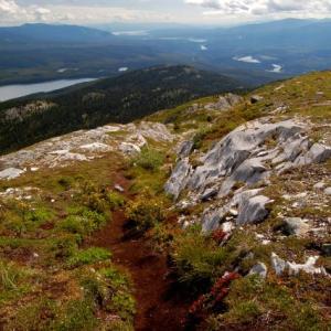
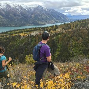
A varied and beautiful trail up into the alpine with gorgeous views of Kusawa Lake and the surrounding mountains. This trail is south of the well-known Kusawa Ridge Trail, and provides a different perspective of the area. This is an especially beautiful hike in the fall and there are many opportunities from the viewpoint to continue farther into the alpine up any of the rocky ridges or towards Jo Jo Lake.
Elevation Gain: 529 m (1736 ft)
Time: 2.5 hours
Difficulty: Moderate
A varied and beautiful trail up into the alpine with gorgeous views of Kusawa Lake and the surrounding mountains. This trail is south of the well-known Kusawa Ridge Trail, and provides a different perspective of the area. This is an especially beautiful hike in the fall and there are many opportunities from the viewpoint to continue farther into the alpine up any of the rocky ridges or towards Jo Jo Lake.
Distance: 8 km
Elevation Gain: 844 m (2769 ft)
Time: 4.5 hours
Difficulty: Moderate
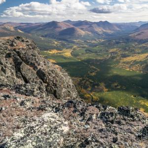
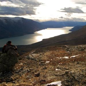
From the summit you are rewarded with a panoramic view of Kusawa Lake and the surrounding area. The ridge is fairly steep and can be quite windy, so be prepared. Dall's sheep frequent the ridge. If you see a group of sheep on a ridge, that is a good clue to adjust your route or turn around and avoid disturbing them altogether.
Elevation Gain: 844 m (2769 ft)
Time: 4.5 hours
Difficulty: Moderate
From the summit you are rewarded with a panoramic view of Kusawa Lake and the surrounding area. The ridge is fairly steep and can be quite windy, so be prepared. Dall's sheep frequent the ridge. If you see a group of sheep on a ridge, that is a good clue to adjust your route or turn around and avoid disturbing them altogether.
Distance: 2 km
Elevation Gain: 250 m (820 ft)
Time: 1.5 hours
Difficulty: Moderate
This is a quick day hike that provides a panoramic view of Marsh Lake, the M'Clintock River, and the Yukon River. Mount Lorne can be seen directly across the valley. There is a very steep trail to the first viewpoint, and then not much of a trail after that, so use your own route-finding skills. NOTE: The M'Clintock Ridge area falls within Category A Settlement Lands of the Kwanlin Dun First Nation. Please respect their rules and land.
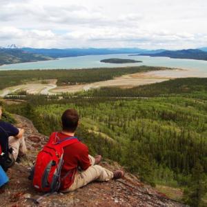
Distance: 19 km
Elevation Gain: 1200 m (3937 ft)
Time: 7 hours
Difficulty: Difficult
When you drive south of Whitehorse, you can't miss this formidable mountain looming in the distance. Mount Lorne offers views of Whitehorse, Grey Mountain, Marsh Lake, Bennett Lake, McConnell Lake, Cowley Lake, and numerous peaks across the South Klondike Highway.
Distance: 6 km
Elevation Gain: 700 m (2297 ft)
Time: 3.5 hours
Difficulty: Moderate
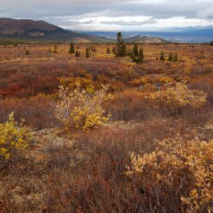
This is a nice day hike an hours drive from Whitehorse that offers a beautiful view of Little Atlin Lake and Atlin Lake. The trail climbs steeply up to a communications tower before continuing into the alpine. The white limestone of this mountain is not what actually gives it its name - it is named after Thomas White, Minister of the Interior from 1887-1888. Watch for mountain goats along the trail. Please refrain from hiking this trail from April 1st to June 15th because the Mountain Goat population uses the area for nursing and raising their kids.
Elevation Gain: 700 m (2297 ft)
Time: 3.5 hours
Difficulty: Moderate
This is a nice day hike an hours drive from Whitehorse that offers a beautiful view of Little Atlin Lake and Atlin Lake. The trail climbs steeply up to a communications tower before continuing into the alpine. The white limestone of this mountain is not what actually gives it its name - it is named after Thomas White, Minister of the Interior from 1887-1888. Watch for mountain goats along the trail. Please refrain from hiking this trail from April 1st to June 15th because the Mountain Goat population uses the area for nursing and raising their kids.
Distance: 4 km
Elevation Gain: 162 m (531 ft)
Time: 1.5 hours
Difficulty: Easy
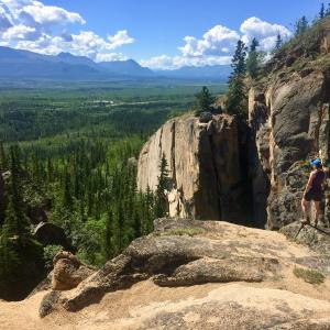
Just barely viewable from the Alaska Highway north of Whitehorse, Spirit Canyon is a beautiful area to explore. The views on the hike to and from the canyon are beautiful, with the expansive Takhini River Valley below and the Ibex Valley to the southeast and the Sifton Range to the northeast. The canyon itself is a special place with big rock walls which are used by rock climbers. A note on parking: Hikers are asked to please not park on the side of the road or block the road for residents that live past the trailhead. There is not enough room for two vehicles to pass each other on this road, especially not in the snowy season. If there is not enough room, consider parking just off the highway in the large parking area. You will have to walk the additional 20 minutes to the trailhead. Add 40-60 minutes to your round trip.
Elevation Gain: 162 m (531 ft)
Time: 1.5 hours
Difficulty: Easy
Just barely viewable from the Alaska Highway north of Whitehorse, Spirit Canyon is a beautiful area to explore. The views on the hike to and from the canyon are beautiful, with the expansive Takhini River Valley below and the Ibex Valley to the southeast and the Sifton Range to the northeast. The canyon itself is a special place with big rock walls which are used by rock climbers. A note on parking: Hikers are asked to please not park on the side of the road or block the road for residents that live past the trailhead. There is not enough room for two vehicles to pass each other on this road, especially not in the snowy season. If there is not enough room, consider parking just off the highway in the large parking area. You will have to walk the additional 20 minutes to the trailhead. Add 40-60 minutes to your round trip.
Distance: 17 km
Elevation Gain: 890 m (2920 ft)
Time: 6 hours
Difficulty: Moderate
The Takhini high country is a great place for a hike. The valley below is home to the Takhini elk herd, introduced into the area in the 1950s. The trail follows an escarpment above Stony Creek and leads right into the alpine. There are beautiful views of the surrounding area including Kusawa Lake.
Distance: 17 km
Elevation Gain: 692 m (2270 ft)
Time: 5 hours
Difficulty: Moderate
The Dream Trail accesses the northwest end of Grey Mountain, high above Whitehorse. It is the final linkage to the main Grey Mountain Trail. This trail is an ongoing project built by the Youth Achievement Centre, BYTE - Empowering Youth and the City of Whitehorse over the last few years. It is a multi-use trail for hikers, runners, and mountain bikers, so be sure to share the trail. The distances and times here are for a there and back trip. You can also decide to continue along the ridge to link up to the Grey Mountain Trail for a longer hike, but you may want to look at dropping a second vehicle higher up the Grey Mountain Road or coordinate a shuttle with friends back down to your vehicle.
Distance: 14 km
Elevation Gain: 100 m (328 ft)
Time: 4 hours
Difficulty: Easy
This trail is part of the Trans-Canada Trail system around Whitehorse. It is a nice forest walk close to Whitehorse with views over small lakes and cool canyons. In the winter, snowmobilers use this trail, which helps pack down the snow so that snowshoes don't have to be worn.
Distance: 6 km
Elevation Gain: 64 m (210 ft)
Time: 1.5 hours
Difficulty: Easy
Starting from the Wolf Creek Campground, near Whitehorse, the Wolf Creek Loop is an easy 6 km hike with views over the Yukon River. The trail weaves through different forest types with expansive views along the Yukon River. It is a popular trail year-round and used by many different types of recreationalists, so make sure to share the trail.
Distance: 10 km
Elevation Gain: 78 m (256 ft)
Time: 2.5 hours
Difficulty: Easy
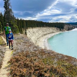
Starting at the iconic Kwanlin (aka Miles Canyon), this trail hikes along the beautiful green waters of the Yukon River. The hike described here includes parts of the Canyon City Trail and the Yukon River Trail.
Elevation Gain: 78 m (256 ft)
Time: 2.5 hours
Difficulty: Easy
Starting at the iconic Kwanlin (aka Miles Canyon), this trail hikes along the beautiful green waters of the Yukon River. The hike described here includes parts of the Canyon City Trail and the Yukon River Trail.
Distance: 6 km
Elevation Gain: 54 m (177 ft)
Time: 2 hours
Difficulty: Easy
An easy hike south of Whitehorse along the beautiful Yukon River. The trail traverses along the high embankment of the river with great views. This trail drops down to the river at the end, where there is a bench and firepit. Caution is required along some parts of the trail where it gets very close to the edge. NOTE: The hike falls within Category B Settlement Lands of the Kwanlin Dun First Nation. Please respect their rules and land.