Atlin
Distance: 109 km
Elevation Gain: 461 m (1512 ft)
Time: 9 days
Difficulty: Difficult
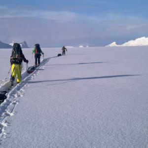
The Atlin to Juneau Icefield Traverse is a a multi-day ski traverse from Atlin, BC to Juneau, Alaska. The route follows along six different glaciers (Llewellyn - Matthes - Taku - Southwest Branch - Lemon Creek - Ptarmigan) for a total of 109 km. Prepare yourself for numerous days of nothing but snow, ice and rock as you travel across this huge landscape. The route described here, including distances and duration is based on flying onto the Llewellyn Glacier from Atlin, skiing across the icefield, and descending via the Lemon Creek Trail to Juneau.
Elevation Gain: 461 m (1512 ft)
Time: 9 days
Difficulty: Difficult
The Atlin to Juneau Icefield Traverse is a a multi-day ski traverse from Atlin, BC to Juneau, Alaska. The route follows along six different glaciers (Llewellyn - Matthes - Taku - Southwest Branch - Lemon Creek - Ptarmigan) for a total of 109 km. Prepare yourself for numerous days of nothing but snow, ice and rock as you travel across this huge landscape. The route described here, including distances and duration is based on flying onto the Llewellyn Glacier from Atlin, skiing across the icefield, and descending via the Lemon Creek Trail to Juneau.

Distance: 5 km
Elevation Gain: 345 m (1132 ft)
Time: 1.5-2 hours
Difficulty: Easy
*** Distance and Time is one way***
Burdette Creek is a beautiful destination in the summer and winter just south of Atlin. The main attraction besides the great access to the alpine is the Burdette Cabin, a beautifully crafted backcountry hut that can be reserved through the Atlin Alpine Society. There are separate routes for each season, with trails built and maintained by the Atlin Alpine Society. From the hut, you can hike Sentinel Mountain and its extensive ridges with sweeping views over Atlin Lake and the surrounding valleys.
Distance: 2 km
Elevation Gain: 213 m (699 ft)
Time: 1 hour
Difficulty: Easy
This short hike in the Atlin area starts from the Como Lake Recreation site. The trail does climb fairly steeply in parts, criss-crossing a mountain bike trail, but the views make up for it on the way up and down. The viewpoint (turn-around spot) has gorgeous views of Atlin Lake, Graham Inlet of Tagish Lake, and Mount Minto (K’iyán).
Distance: 15 km
Elevation Gain: 655 m (2149 ft)
Time: 4 hours
Difficulty: Moderate
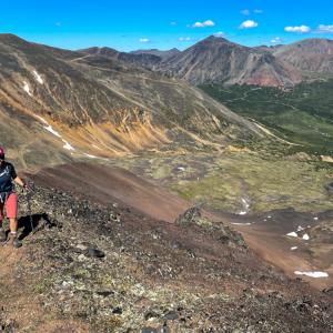
The alpine of the Eldorado Creek Valley is a beautiful area south of Atlin, near Sentinel Mountain in the Johnson Range. This is recommended as a backpacking trip with 1-2 nights in the alpine and adding on a side trip up Sentinel Mountain and its extensive ridge. The views along the ridge are stunning with a glimpse of Atlin Lake and the icefields beyond. Add 8-10 km return and another 500 m elevation gain if you are hiking Sentinel Mountain and its ridge.
Elevation Gain: 655 m (2149 ft)
Time: 4 hours
Difficulty: Moderate
The alpine of the Eldorado Creek Valley is a beautiful area south of Atlin, near Sentinel Mountain in the Johnson Range. This is recommended as a backpacking trip with 1-2 nights in the alpine and adding on a side trip up Sentinel Mountain and its extensive ridge. The views along the ridge are stunning with a glimpse of Atlin Lake and the icefields beyond. Add 8-10 km return and another 500 m elevation gain if you are hiking Sentinel Mountain and its ridge.
Distance: 7 km
Elevation Gain: 700 m (2297 ft)
Time: 3 hours
Difficulty: Moderate
If you're in or around Atlin, be sure to do this hike - it offers some great views of Atlin Lake & Atlin Mountain as well as Teresa Island, the 2nd tallest lake-island on the planet. Monarch is not the highest mountain in the Atlin area, but it is a great short day trip that gets you up to the alpine to view the other majestic peaks.
The mountain lies within the A Xéegi Deiyi Conservancy. The name means the 'shoulder trail' and this area protects a culturally significant and spiritual area for the Taku River Tlingit people.
Distance: 7 km
Elevation Gain: 196 m (643 ft)
Time: 3 hours
Difficulty: Easy
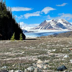
This is a spectacular hike at the southern end of Atlin Lake to a view of the mighty Llewelyn Glacier. It is a very remote hike requiring either motorized boat access, floatplane access or kayak/canoe access on the largest natural lake in British Columbia! The hike itself is on a trail maintained by BC Parks. The trail travels over varied terrain, taking you through balsam fir forests, to viewpoints of a beautiful little lake, along a turquoise blue creek and across glacial valleys to a very spectacular viewpoint. There is a good amount of ups and downs, with little overall elevation gain. Great day hike or overnight trip.
Elevation Gain: 196 m (643 ft)
Time: 3 hours
Difficulty: Easy
This is a spectacular hike at the southern end of Atlin Lake to a view of the mighty Llewelyn Glacier. It is a very remote hike requiring either motorized boat access, floatplane access or kayak/canoe access on the largest natural lake in British Columbia! The hike itself is on a trail maintained by BC Parks. The trail travels over varied terrain, taking you through balsam fir forests, to viewpoints of a beautiful little lake, along a turquoise blue creek and across glacial valleys to a very spectacular viewpoint. There is a good amount of ups and downs, with little overall elevation gain. Great day hike or overnight trip.
Distance: 5 km
Elevation Gain: 504 m (1654 ft)
Time: 3 hours
Difficulty: Moderate
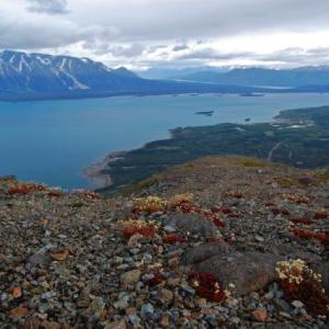
Ruby Mountain is a beautiful and accessible hike near Surprise Lake, northeast of Atlin, BC. It is part of the Atlin Volcanic Field, and red coloured tephra adorns the summit and flanks giving it that red 'ruby' look. The route is straightforward and the hike is less than 5 km return with about 500 m elevation gain. There are some rocky sections and a bit of exposure at the top to add to the excitement. Watch for Dall's sheep and caribou in the area and give all wildlife a wide berth.
Elevation Gain: 504 m (1654 ft)
Time: 3 hours
Difficulty: Moderate
Ruby Mountain is a beautiful and accessible hike near Surprise Lake, northeast of Atlin, BC. It is part of the Atlin Volcanic Field, and red coloured tephra adorns the summit and flanks giving it that red 'ruby' look. The route is straightforward and the hike is less than 5 km return with about 500 m elevation gain. There are some rocky sections and a bit of exposure at the top to add to the excitement. Watch for Dall's sheep and caribou in the area and give all wildlife a wide berth.