Total Distance: 17 km
Return Time: 6 hours
Elevation Gain: 890 m
Difficulty: Moderate
Region: Whitehorse
Traditional Territory: CAFN, KDFN
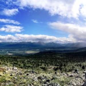
The Takhini high country is a great place for a hike. The valley below is home to the Takhini elk herd, introduced into the area in the 1950s. The trail follows an escarpment above Stony Creek and leads right into the alpine. There are beautiful views of the surrounding area including Kusawa Lake.
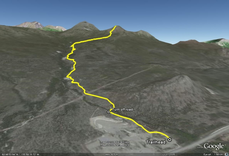
Drive north of Whitehorse on the Alaska Highway for about 61 km. When you reach the Takhini River bridge, you have 15 km more to go until there is a gravel pit on the right side of the highway. Turn off the highway at the gravel pit where there is a yellow gate, and make an immediate right before the gate. Follow the road for about 50 m back in the direction towards Whitehorse and park. The trail starts from the east side of the gravel pit.
From where you parked, walk up the road for 500 m. When you come to a fork, take the right fork up the road. It eventually follows Stony Creek up above the escarpment. After 4.5 km the trail leaves the escarpment and climbs towards the peak in front of you. The trail ends after about 7 km.
From the end of the road you can make your way up the peak in front of you. Spread out to minimize damage to the fragile lichen. It's just over 1 km to the summit from the end of the ATV trail. Follow the same route back.
Dog Owners If you bring a dog on this trail in the winter, make sure it is on a leash. The Stony Creek trail is a snowmobile route on an active trap line. There are baited traps, which could be deadly for your dog.
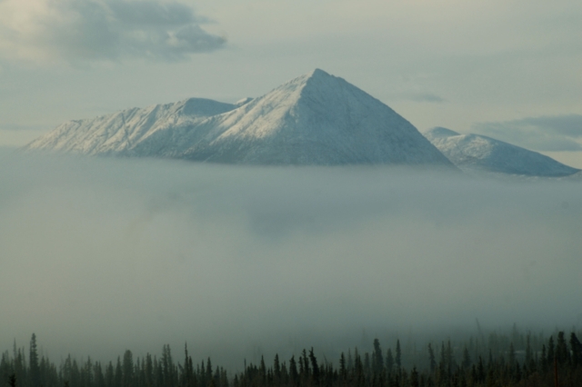
Morning fog encapsulating the mountains on the other side of Takhini River.
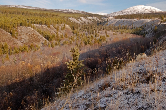
Looking up Stony Creek escarpment towards the peak.
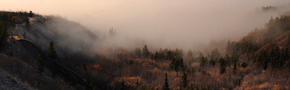
Low fog in the valley above Stony Creek.
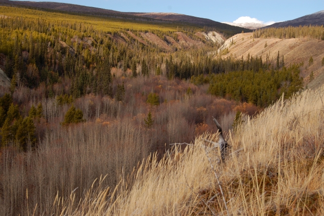
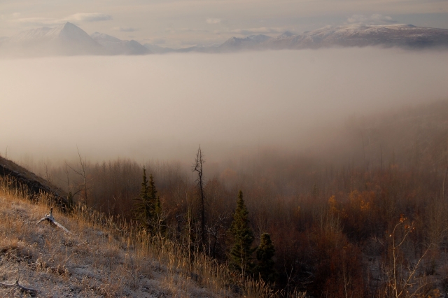
Stony Creek ravine.
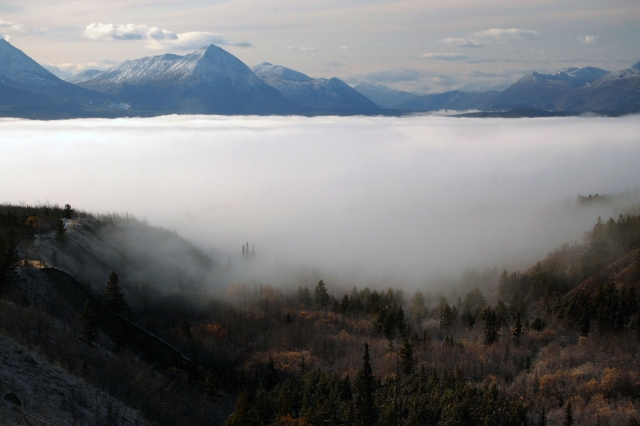
More fog, creeping up the valley towards us.
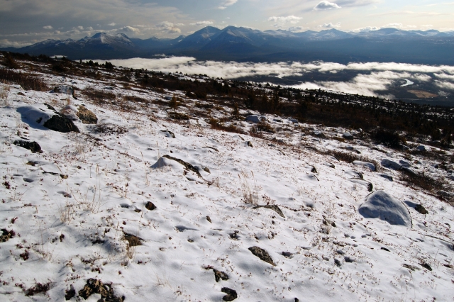
Near the summit, looking towards the Takhini valley with Takhini River just visible on the right.
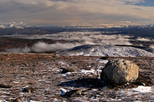
Looking east from the summit.
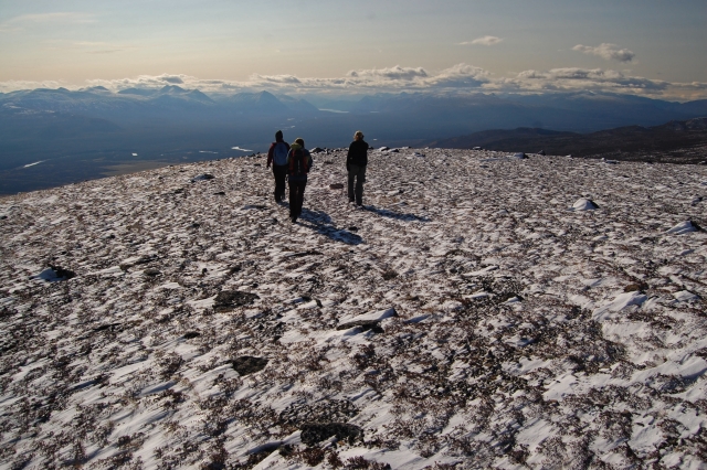
Heading back down from the wind-swept summit with Kusawa Lake in the distance.
Maurice Perreault October 15, 2025
For those seeking a bit more adventure up Stony Creek: Instead of going up the first bump, keep going on the less defined quad trail until it runs out, and then keep going to the summit. The terrain travels well as long as you maintain a bit of elevation traversing the 2nd bump. Plan on 15+km of off-trail travel.
We hiked it on October 13 in the crazy windstorm. Winds were sustained 80km/hr. for about 2 hours in the highest elevation. Poles, steady legs and experience were mandatory. Walking was... pushy! On the good news, about 4"-6" of snow was sublimated away during the day alone, so conditions should be quite pleasant for anyone wanting to go up before a substantial snow storm.
Total distance is 32km with 1300m elevation gain. Views were good. I would say 10 hours for average fitness/moderate pace. There's a small stream and lake before the main summit peak you can camp at or get water from if desired. Likely a windy place to camp.
Go get it, and happy hiking!

Shailyn September 8, 2025
Hiked on September 7th. Definitely a great trail for the autumn colours. It didn't seem quite at its peak yet - but soon. Took about 6 hours, lots of wind at the top. Saw a porcupine and got spooked by a huge dog that lives at the mine. Lots of bear scat full of crow berries (about a week old), but luckily no sign of its owner.
Aaron Weber July 20, 2025
Hikes the trail yesterday, conditions were fantastic! Trail was dry the whole way up, beautiful views and a lunch spot at the top.
We saw lots of squirrels and birds, but no larger wildlife. Saw what seemed to be some month+ old bear poop, but no signs of recent movement
Ree May 25, 2025
Hiked all the way to the top this time (May 24). A couple minor mud and snow patches but they were easy to circumnavigate - for the most part, it's completely dried out and no snow left in the alpine (although it's neighbour, Stony Peak, is still quite snowy). Beautiful views! Some recent bear and moose tracks on the trial but no wildlife sighted. 2.5 hours to reach the top then 20 min (epic) bike ride down.
Ree April 26, 2025
Hiked part-way today (April 26), the first couple kms were nicely dried out then ran into snow patches around 3-4 km. The snow isn't deep and still nicely packed for the most part so it's definitely do-able but will probably be another few weeks before it completely dries out. The alpine has snow but doesn't appear to be deep. No large wildlife sightings.
Shailyn September 23, 2024
Hiked on September 15th. The autumn colours were epic and at it's peak. I highly recommend this one for autumn colours. It's always a long hike, but really nice at the top. Didn't see any wildlife (or signs of wildlife), but there was a couple hunters near the summit.
Larissa June 13, 2022
We encountered a grizzly ~7-7.5km in, past the end of the ATV trail right before the alpine. We made loud & constant noise the whole way up but he was still right there when we turned a corner on the trail. We set off multiple bear bangers, he ran up a bit from the first one but came back, second one he was completely unbothered and continued to approach us through the bushes this time where we had no visuals but could hear his vocalizations. It sounded like he came within 20 feet. This is the first time either of us have encountered a bear that wasn't deterred immediately by human noise or bangers. I won't speculate too much as I'm no a bear behavioral expert but it's possible we were getting close to a kill site and they were defending their food.
As for the actual trail - The previous commenter's remarks on the trail are still accurate, trail has dried up except for a relatively short muddy section.
Kathy June 5, 2022
2022-06-04 Stony Creek. Hiked Stony Creek, all dry with a couple of patches of snow, about 70m of muddy section and the creek maybe 10cm water. Very nice trail with great view from the top. A bit of a grinder @ 17km, 890 M, fantastic view from the top!!! Your trail directions were easy to follow.
A & M May 21, 2022
We went up May 21 and there was still a lot of snow so only made it 5km. Snow was up to mid-thigh in places from 4.5-5km!
Liz B June 20, 2021
My partner and I hiked this on June 20th. The parking and trail directions were very easy to follow. The trail ends in the alpine and it's no problem to pick your way up the rest of the slope to the top.
We saw some relatively fresh bear scat about halfway up the trail and we saw one small black bear on the way down but he was on the other side of the Stony Creek ravine so no issues there.
We used our Garmin to track the hike and our stats were 978m elevation gain and 17kms return trip (we did a bit of extra exploring at the top). The hike took us 6.5 hours, including lunch, snacks and a bunch of photo breaks throughout. The trail is very well defined and not steep. There is no scrambling or scree slopes on this hike which makes it a great option for those who don't enjoy the difficult terrain you can find on other hikes.
You are in the trees for most of the hike but the views are great once you get up into the alpine (about 6.7kms up) and there are plenty of extra exploring opportunities at the top.
David June 8, 2021
We enjoyed a warm and sunny hike up Stony Creek on June 7th. Most importantly it was virtually snow free all the way! The trail is well traveled and easy to follow until the alpine when it's easy to pick your own way to the summit. A little longer than most hikes around but as a result it's quite easy going and not steep at all.
Marc October 5, 2017
Yes, directions provided are good. It is 15KM passed the Takhini River bridge on the Alaska Highway (not Klondike Highway). If you drive 15KM's passed the Bridge on the Klondike river (heading north), there are no hikes there. It is going towards Haines Junction.
Doe October 5, 2017
@John Doe, in fact, it is northwest from Whitehorse so the directions and you are both correct. The Alaska Highway has a northwesterly direction as built. There are two bridges across the Takhini River. One is over the Klondike Highway (a.k.a. Mayo Road) and the other is over the Alaska Highway. 15km past the bridge over the Takhini River, on the Alaska Highway, is where you need to focus. The trailhead is at a gravel pit on the north side of the highway (right hand side travelling from Whitehorse). To me, the directions provided are clear. I've hiked this trail a few times. Directions are good.
John Doe October 4, 2017
I don't understand the directions:
"Drive north of Whitehorse on the Alaska highway for about 58 km. When you reach the Takhini River bridge, you have 15 km left."
Based on the map the trail head is along the Alaska Highway heading west, not north as you wrote. This isn't near the Takhini River bridge at all.
Mabel June 1, 2017
We hiked this on May 20th. Trail head was very easy to find. Really beautiful hike! It can be a little confusing at times sticking to the ATV trail as there are also roads leading to private mining claims but you'll realize pretty quickly if you're on the wrong path. We saw a grizzly about half way on the other side of the creek. We only made it to the end of the ATV trail and not to the summit and it took us around 4.5hrs roundtrip.
AdventureGal May 8, 2017
Hiked Stony Creek this past Saturday with a group of friends. A couple pushed their bikes up about 5km and had a wicked ride down. Very easy to follow trail and VERY sandy and dusty at this time of year, freshly graded that day. We stopped for lunch at the 7.5km mark where the ATV trail ends and the trail opens up to the mountain face, which gave us a sweet view and little wind. We had the pleasure of watching 2 grizzly cubs roll and play in the snow below us from the summit. Took us 6.5 hours with lots of stops and summit beers.
Pat & Nikola April 30, 2017
Great trail and easy to follow. Got together with a group of people and had a nice casual hike up to the summit. Took us around 7.5 hours. Beautiful sights all the way up, with great views of the tahkini river , kusawa lake and the Ibex valley . Still a bit of snow left in some parts of the trail .
Fan of this website April 21, 2017
Don't go with a loose dog. Even in summer there are traps around. We went up late August and my dog found a trap with what looked like a fresh cross fox in it. A group of men on the trail warned us about our loose dog because the last time they were hiking this trail a women's dog was injured then died later from getting caught in a trap.
Andrea Altherr March 10, 2017
Great conditions for skiing. Hard packed base and 5-10cm soft snow on top of it. Couldn't get any better!
Pippa May 15, 2016
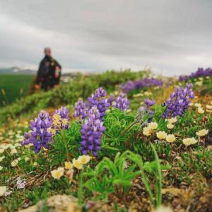
Back again to get the right trail! Made it to the top this time - wildflowers already out although some tarns still frozen and lots of snow on the East faces. Easy hiking all the way, although the lower part of the road is now in active use (mining signs) and as a result, the surface is loose (sand mostly). Would be tough biking. One of the trucks we saw was dragging a grader/rake up the road (as we left). Description is spot on and estimated time is accurate for fit folk. You can easily spend more time on top.
Leah & Curt July 31, 2015
We did this trail yesterday. Beautiful hike with stunning views of kusawa lake, takhini river and ibex valley.
It's a fairly steady incline for the entire 8km to the summit area. Lots of small steep hills.
We did 16km total because we off roaded a bit. Excellent ATV trail though!
We came home with sore feet, exhausted bodies but lifted spirits at our accomplishment!
Points to mention:
There is NO water source to filter from so bring plenty of it!!!
It took us 7.5 hours with our rest stops.
You'll see mining stuff along the way.
Pippa July 29, 2014
Don't miss the right turn just after the start of the hike!
The dirt road makes a sharp right turn just a few hundred metres or so into the hike. It also continues straight ahead. Deep in chat, we missed the turn and merrily continued along the road which became a gradually disappearing path, into the creek ravine that just gets deeper and deeper. Ended up bushwhacking out of the ravine onto the other side. It was nice walking for quite a while up the western edge of the ravine. We thought we could do a loop up that one side and back on the trail. But it got nasty so we descended into the ravine and bushwhacked over the creek and up the other side. Much better to stay on the trail and avoid the bush!
Travis May 12, 2014
Did this hike on Sunday, May 11, in a group of four. The entire trail was snow free and only a few small sections of the 4x4 road were muddy. Great day hike with only gradual elevation gain. We completed it in just over 6 hours, with plenty of breaks in between. Lots of ptarmagin in the alpine, and 5 dall sheep were spotted on an adjacent mountain.
Note: There is good potential for overnight camping with lots of alpine walking and a few lakes to explore once up on the summit.
Alastair Cook September 2, 2012
On September 1st a group of us hiked this trail. The weather was cool and cloudy, but visibility very good. The trail is indeed very good and easy to follow and great views at all times. There were a couple of old mining artifacts along the way... a log structure housing a machine that ran a sluicing operation of sorts, and at the bottom of a ravine near the creek, another wooden building which was somehow involved in the same operation no doubt. It is well worth the effort to make it to the very top of the trail..ie,the summit, as the 360 degree views are breathtaking. It was extremely windy at the summit, but it felt right.
We took longer than the suggested hike time of 6 hours, but not too much more.
I would also debate the allocation of EASY to this trail..admittedly it's well marked but its overall elevation gain of nearly 3000 feet and 17km distance requires stamina and determination nonetheless.
Recommended.
