Total Distance: 5 km
Return Time: 4 hours
Elevation Gain: 961 m
Difficulty: Difficult
Region: Annie Lake
Traditional Territory: CTFN, KDFN
This route is a great challenge. It has it all - steep hiking, bushwhacking, nearly 1,000 m elevation gain, wildflowers, ridge walking, towering rocky pillars, and amazing views. The route is up the north end of what is known as Grey Ridge, a series of peaks stretching along Annie Lake and the Wheaton River (Needle Mountain, Mount Gilliam, Surprise Mountain, Pyramid Mountain and Mount Gray).
Please avoid hiking this trail from April 1-June 15 to avoid disturbing the sheep during lambing season.
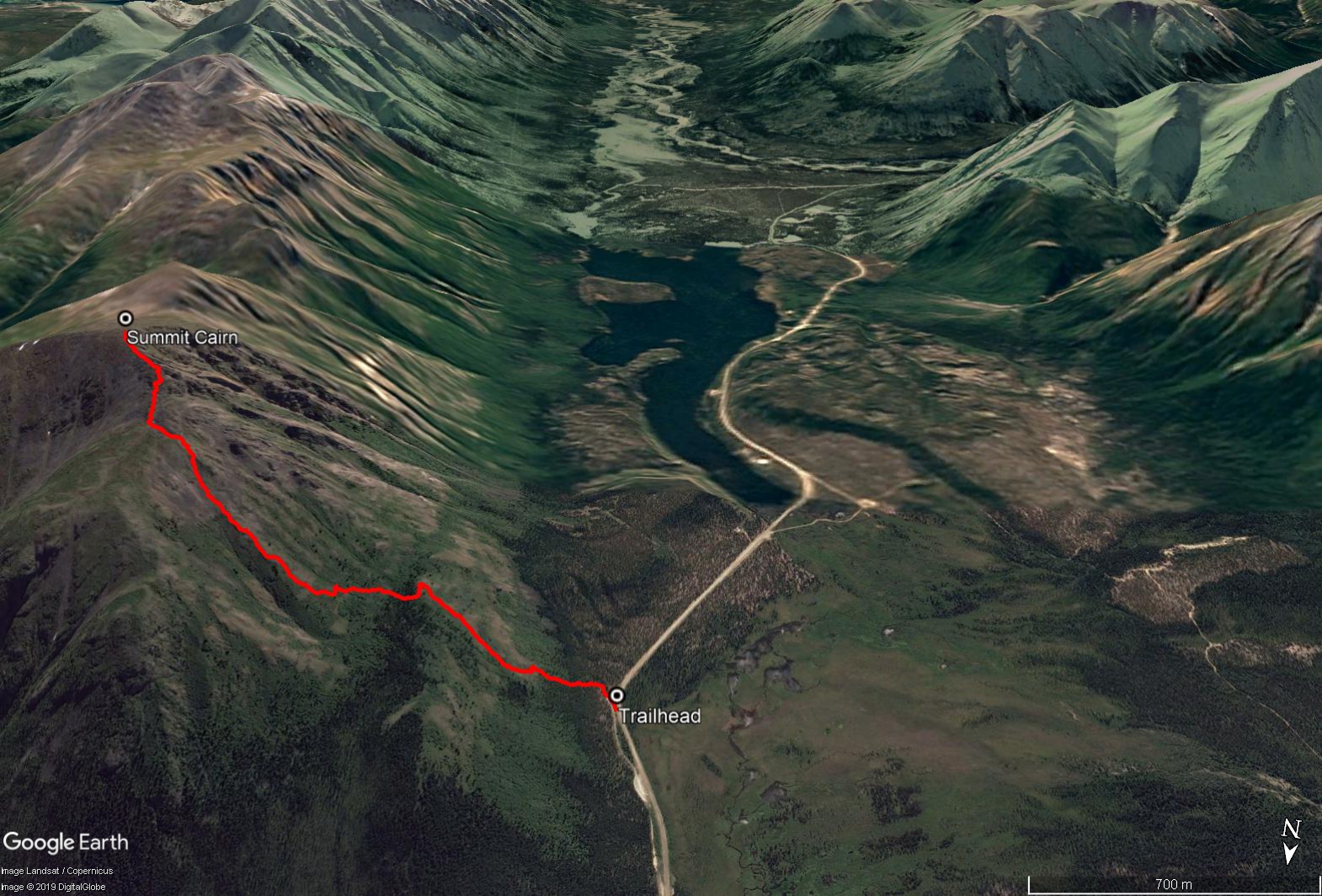
Drive south from Whitehorse on the Alaska Highway and turn right at the Carcross Cutoff onto the South Klondike Highway. After about 17 kms turn right onto the Annie Lake Road (which will quickly turn into a dirt road). After 16 kms on the Annie Lake Road you will come to a curve before reaching Annie Lake itself (approximately 1.4 km before the lake). Here you can pull off the road on the left, where you'll see a side road or ATV trail, which parallels the main road.
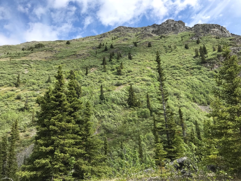
From where you park follow the ATV trail into the forest to the southeast for about 120 m. Then start heading straight up the ridge on your left through the trees. It is pretty easy bushwhacking over juniper and kinnickinnick shrubs in the relatively open mixed forest. Eventually the forest gives way to a steep open ridge. Continue to make your way steeply uphill making your way around any rocky cliff areas.
After a total of 350 m of elevation gain you should reach a small plateau dotted with more trees partway up the mountain. From here, head slightly north along the treed ridge (for about 70 m) and then cut down through the conifer trees, to reach the base of the next part of the mountain. This is where the bushwhacking really begins.
It looks like you can avoid some of the bushwhacking by reaching some open rock patches along the way, but these don't last for long and there is not much you can do to avoid the willows. Battle your way up, keeping slightly to the left of the rocky cliffs above you. After 50-60 m of bushwhacking elevation gain, you should be through the worst and climbing up in the open alpine. Mid- to late-June is great time for wildflowers, and will help you forget about the nasty willows bellow.
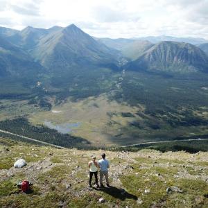
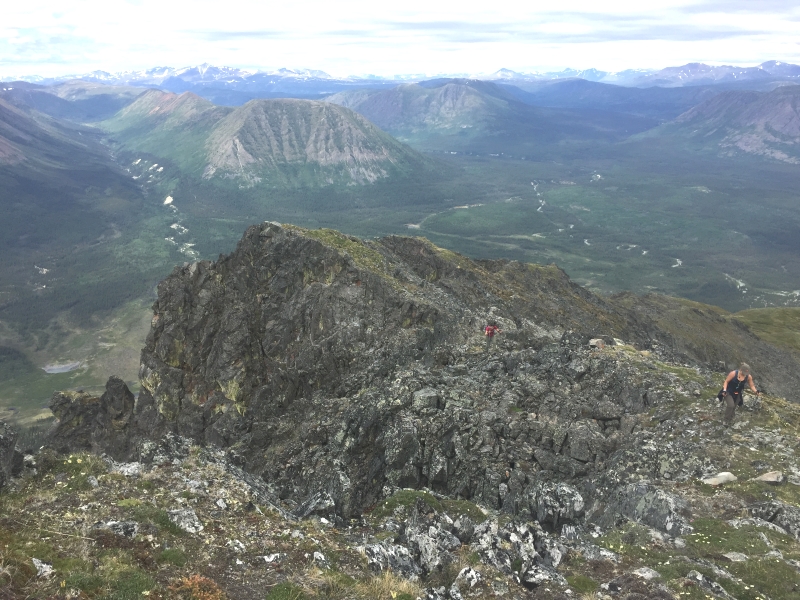
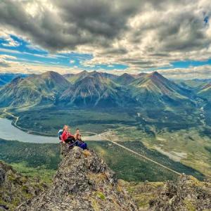
Soon you will reach the top of the ridge. Then head right (southeast) for 600 m to the summit, navigating around the rocky steep ridges. There is a summit cairn at the top. There are so many gorgeous views along the ridge looking down at the rocky pinnacles of Needle Mountain and down to Annie Lake.
There is so much to explore in this area. You could continue along the ridge to the next unnamed peak and onwards along Gray Ridge if you have more time. Return the way you came up, knowing that the bushwhacking is easier and faster on the way down.
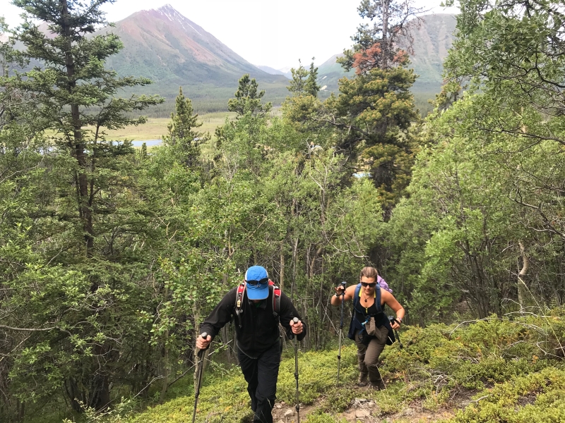
Hiking up through the open mixed forest from the ATV trail.
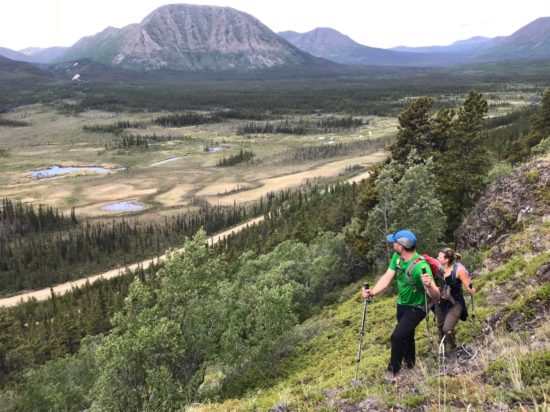
The first views of the valley below and Red Ridge in the background once you exit the trees.
Looking up to the main section of bushwhacking.
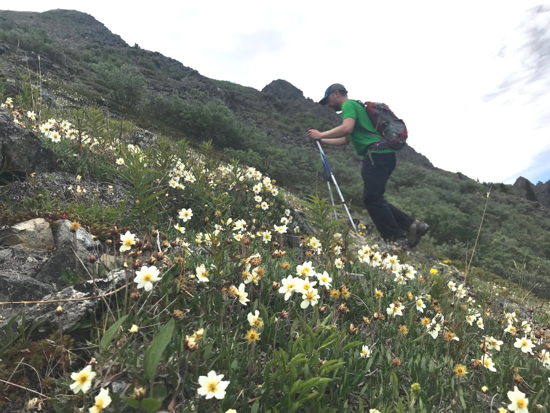
Alpine wildflowers in full swing just below the top of the ridge.
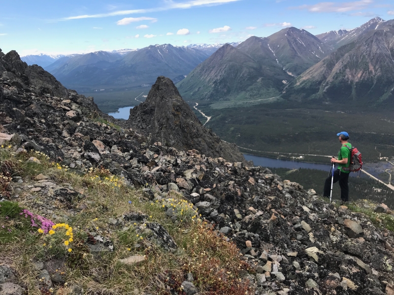
Reaching the ridge and enjoying the views below of the rocky pinnacles.
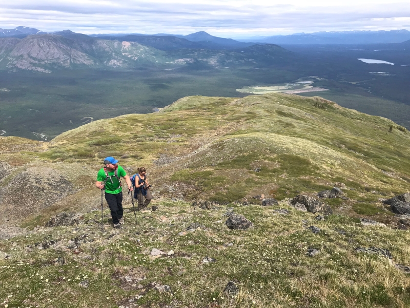
In contrast to the rocky, steep south-facing side of the mountain, the north-facing side is more rounded and gradual.
Fun ridge walking near the top of the summit with Red Ridge and the Watson River Valley below.
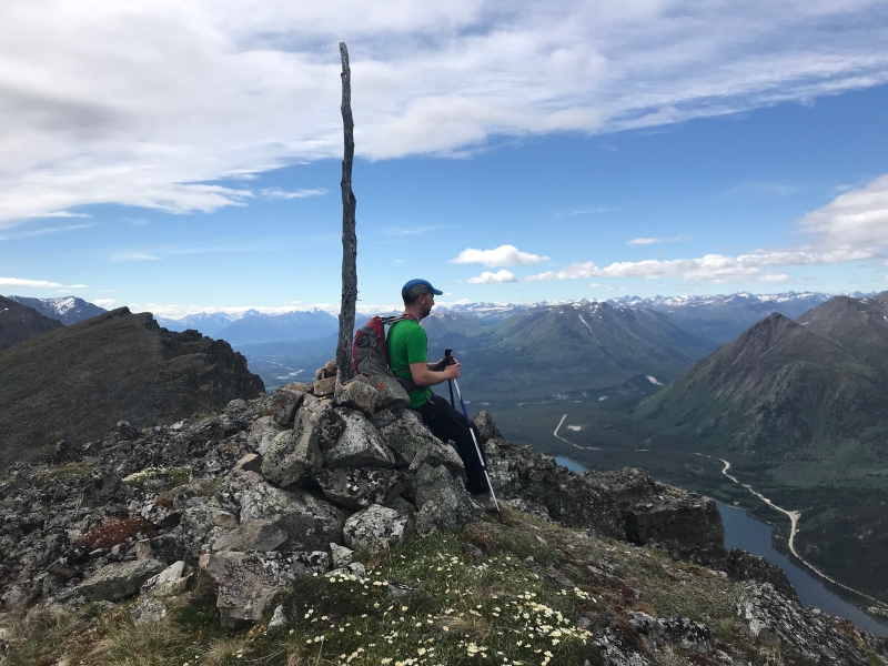
The summit cairn with the Gray Ridge continuing to the south.

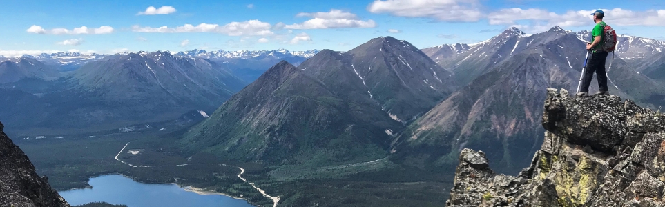
The view looking southwest from the summit of Needle Mountain.
ElizJB August 25, 2025
My partner and I hiked Needle Mountain on August 25. We didn't follow the directions posted here, we parked off Annie Lake Road, a bit before these directions and went straight up. The climb is incredibly steep and relentless with very few flat-ish spots to take a break. We hiked up the left side of the gully (Yukon Hiking route takes you up the right side) and we had very little willow bushwhacking. That being said, there was a ton of bushwhacking through spikey juniper (maybe that's why it's called Needle Mountain).
According to our Garmin, we did 730m elevation gain before we got into the alpine and another 300m got us to the summit for a total of just over 1000m elevation gain. Total return distance was 7.4kms.
Saw some ptarmigan, warblers, waxwings and lots of other bird species. Signs of moose, sheep and bears but no sightings.
Great views and neat rock formations at the top but I can definitively say this is my first and last time doing this hike. My partner and I are experienced hikers and we found this one pretty challenging.
Bring hiking poles!!! They will absolutely save your knees and ankles on the way down.

Eddy and Pauline September 19, 2022
Amazing hike! Few tracks but clearly a steep fuzzy route all the way to the alpin ridge. Can be a challange who requiered confidence. After the plateau, might be easier north on a "low rocky ridge" than straight in the bushwhacking. The alpin part is a real pleasure.
Marianna July 24, 2022
Celebrating a birthday on top a mountain with a gourmet cake was something none of us had done before, besides, Needle mountain was a first for all of us.
Her majestic beauty is not easy to capture, it takes hard work, a lot of steep bushwhacking and intuitive navigation as the trail is not visible.
Don’t let the short distance fool you, it very steep, conditions were great, lots of bugs. All of us had sore knees and jello legs at the end and we are all fairly fit. Did the hike on July 23, 2022.
Laurie July 23, 2021
We went on July 22 2021 and there was no flag on the route.
Expect a good km in bushwacking, and if more, try to move on your left where there is a small plateau. We enjoyed the view but note that the ascent wasn't really fun: the bushwhacking is really challenging and I ended up stepping on a wasps nest and got stung three times.
Thankfully the view was good!
Glenda July 31, 2020
Thanks for posting this great hike. I'd like to reiterate what the previous poster said. You can avoid almost all bushwhacking beyond the small plateau/bench by heading for the open slope to the north. Someone has kindly flagged this route, and it looks like it has been used often enough that it's becoming a trail.
I also recommend gaiters to avoid getting juniper needles in your boots, which might be the *real* reason it's called Needle Mountain.
Sam July 20, 2020
Hiked this on Sunday & it was awesome. We overshot start of the hike and ended up having to sidle back towards to plateau before the main climb. When you leave the parking spot/ATV trail, start the ascend almost right away through the trees, don’t follow the tempting well worn trail towards Annie Lake. Epic views and rock formations/pinnacles at the summit. There’s no real trail, but would recommend aiming for the ridge on the far left to hike up, further left than what it shows on the map here. We came down that way, there’s less bushwhacking plus it seems like the most direct route.
Kyle August 12, 2019
Epic hike!
The bushwacking was diffifult and it is very steep but well worth it at the top (bring gloves). 10km total, took 2:20 going up and an hour going down. We hung out at the summit for about an hour to explore and enjoy the views.