Total Distance: 7 km
Return Time: 3 hours
Elevation Gain: 700 m
Difficulty: Moderate
Region: Atlin
Traditional Territory: TRTFN
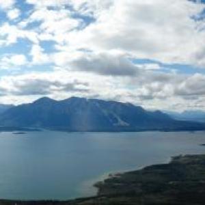
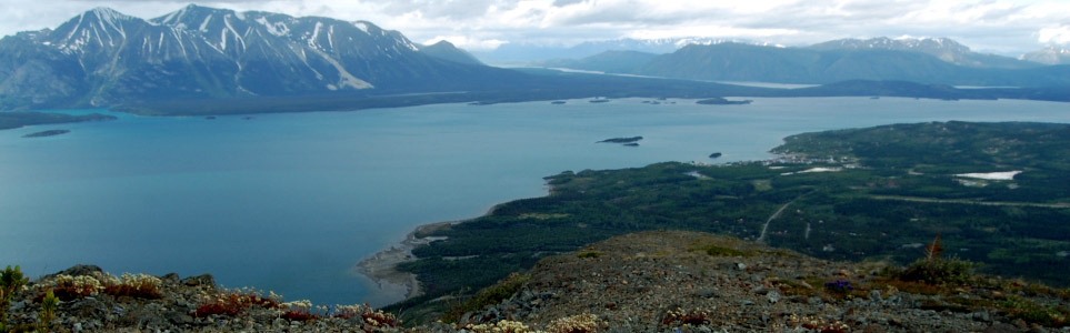
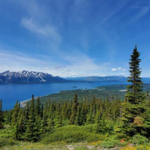
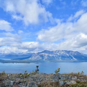
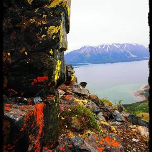
If you're in or around Atlin, be sure to do this hike - it offers some great views of Atlin Lake & Atlin Mountain as well as Teresa Island, the 2nd tallest lake-island on the planet. Monarch is not the highest mountain in the Atlin area, but it is a great short day trip that gets you up to the alpine to view the other majestic peaks.
The mountain lies within the A Xéegi Deiyi Conservancy. The name means the 'shoulder trail' and this area protects a culturally significant and spiritual area for the Taku River Tlingit people.
Coming into Atlin on Highway 7, at the T-junction turn left onto Surprise Lake Road (right goes to Atlin on Discovery Ave). After that, take a right on Warm Bay Road. Continue for 3.5 km until you reach a moderate sized parking area on the right hand side of the road that has a trail sign. The trailhead is on the other side of the road.
At the parking area there is a sign that points to the trail across the road. Cross the road to get to the trailhead. The trail is easy to follow and climbs steadily at a moderate grade.
The trail crosses a road and a driveway at the beginning. You will soon get some unobstructed views of the surrounding area as the trail winds in and out of the forest. There are a couple of benches along the path that offer good resting points with great views.
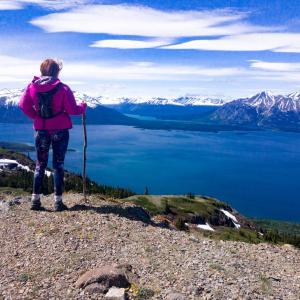
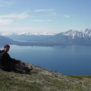
Once in the alpine, you will see some cairns (rock piles) marking some of the summits. There are two main summits with amazing viewpoints and many good spots to take a break. If it is windy, you'll have to find some shelter behind trees or rocky hills.
There is some room for exploring at the summit down to some tarns or around the rocky ridges. NOTE: The two small lakes on the summit plateau are used for spiritual activities, so please respect the privacy of people who travel there and leave the area clean and pristine.
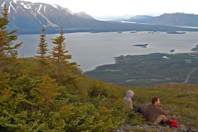
A nice viewpoint with a log bench, looking towards Teresa Island.
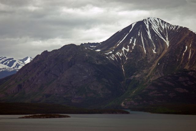
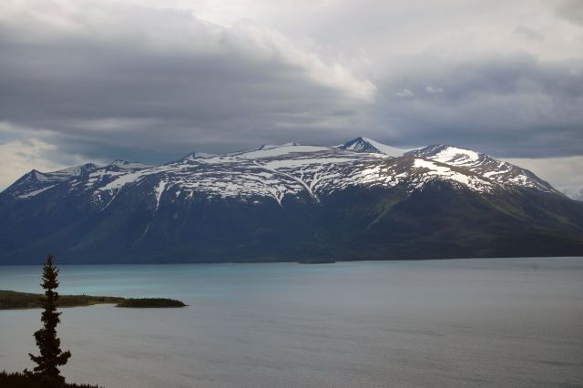
The massive Atlin mountain. Photographer - Michael Kulachkosky
Teresa Island from the first viewpoint.
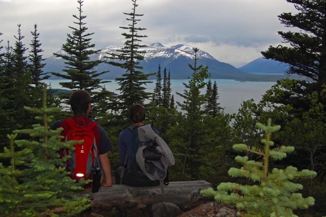
A rest in the shelter of some trees at the summit.
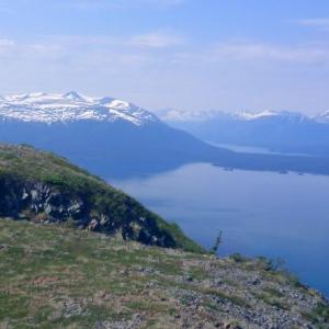
Atlin Lake, Atlin Mountain, and... Atlin.
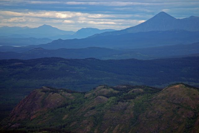
Looking north from the summit. Photographer - Michael Kulachkosky
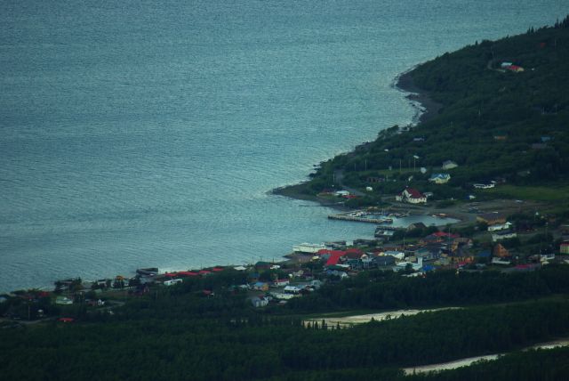
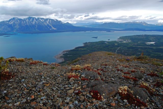
Looking down at the town of Atlin. Photographer - Michael Kulachkosky

AG May 16, 2026
Hiked May 15, 2026; only went up to the bench lookout due to time and young kids hiking with us. Was fully clear of snow less a few patches of snow that were easy to walk around. Looked like it would have been doable to the summit. Lots of crocuses in bloom. Saw a deer along the trail, and many, many animal droppings all along the trail - deer, moose, and bear!

Craig Benson - August 10, 2024 August 19, 2024
Stunning views - I have this as my screen saver now and can't get over how blue and beautiful it is. We went up early and there were only one other person. On the way down however, there were many.
It was windy all the way up and at least 10-degrees colder on top than down at the road. Great hike!

hello September 17, 2022
been up that mountain several times over a few years around 50 years ago ... everything sounds about the same.... some rare butterflies for bc . found ONLY at the VERY TOP ... at least 3 species or subspecies....it can be windy at the summit ... these northern species were probably trapped as the ice sheets retreated ...... probably found on other mountains in northern bc .... the hot springs were there.......small ... stumbled on them by accident...grizzly country..saw one on the main Atlin road by a garbage can on the hike up I had bells to ring so any would be aware.... thay are afraid of haumans thx
Gerald Marchildon August 14, 2022
Hi,
Just wanted to bring to your attention that in your Driving Directions, it should be «Warm Bay» ... not «Warm Springs».
We drove approximately 30 km past the Warm Bay sign looking for the Warm Springs sign ... which we never found. When we returned to Atlin, we asked at the gas station and were told that to turn right on Warm Bay, less than a km out of town.
We've attached a photo of the road sign.

YukonJudy July 3, 2022
Great day for a hike
Anyone can do this hike, slow and steady. The worst part was the hordes of mosquitos, they were terrible. I had to reapply bugs spray three times and was still eaten.
Not even a wisp of a wind for the entire hike up and back down.
Simon Blunden June 12, 2022
Hiked on June 11, 2022. Trail was clear and easy to stay on. Weather was partly cloudy and around 14c, but cooler at viewpoint. Perfect condition s except some snow to navigate at around 1300m. Fine to walk up snow, but recommend sliding down on your bum. Would highly recommend poles, particularly to assist with descent. This is not an easy hike and you should be in good physical shape. However, views at top and along the way are breathtaking. Took me just under 3 hours round trip from Monarch mountain Cabins (where we stayed). No water along trail so make sure you pack some
Miaclaire April 12, 2021
Hiked this yesterday, April 11 2021. The trailhead was almost invisible from the amount of snow and the snowplow piles by the road. The trail was very unused, invisible in many places, and the last tracks were not recent and did not go up the whole mountain.
Brought snowshoes but they were not very useful as the snow had been half melted and re-frozen / packed. It was a super warm day though and by half-way up, after maybe ditching the snowshoes prematurely, it was too slippery for the boots I was wearing to continue up.
I think crampons / hiking spikes would have been a lot more useful than snowshoes!
Cam June 29, 2020
This hike has very nice views all the way up!
The trail is well defined and easy to follow. It’s a steady, steep climb right from the beginning. Took us 1.5 hours to get to the top ( with many little stops to rest the legs) and then 1 hour to get back down. Poles are a wonderful option especially for the descent.
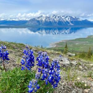
Didn’t see any wildlife but did see a vast collection of wildflowers and many fellow hikers with their dogs.
Garth July 15, 2018
Hiked this on the evening of July 12th. Trail is dry, very windy up top. Got to the main viewpoint and continued on to hike a little circle of the ridges to the true summit - great views of the lake and mountain range!
Emma June 20, 2018
I did this one in September 2017 and LOVED it.
Its a fairly modest climb up a well defined path to the summit. The views of Atlin Lake and the surrounding Mountains on a nice day are pretty incredible. As with most hikes up this way, it was very windy at the top, so we headed down to the plateau area to stop for snacks. All up, it took about 2:30-ish return.
A definite hike to do if you're in the Atlin area.
Kyle June 19, 2018
Did this one on June 17 2018.
Great day hike, very clear and well maintained path up to the summit.
Sweeping views of Atlin lake, the mountains and como lake.
Cor August 21, 2017
I live in Atlin, and this is a popular hike for locals, too - winter and summer. You get amazing views, even if you only have time to hike up a little ways. It's also a great way to get in an outdoor workout as it is a steady upward climb the whole way. Bring poles for the descent of you have bad knees!
As noted in a comment below, trail is accessible from Warm Bay Road (not Warm Springs as said in description). There is a large pullout on the right that is also the access to the Beach Trail. Nice spot to go dip into after your hike, on the rare hot hot day. You'll see Monarch Trail sign across the road from pullout.
People usually hike to the false summit for the best views, but to get to the real Monarch summit, you must descent behind the false plateau-type summit and head up the trail/peak veering left from the pond below (note, it is not the first pond you see when getting to the top, it is the second viewed behind the false summit). When you get to the true summit, you will also have spectacular views of Como Lake & Minto Mtn to the north, Surprise Lake to the East, and of course Atlin Lake & Mtn to the south and west.
Happy Trails!
Max Benis August 13, 2017
Didn't see any Moncarch Butterfiles on this hike! But oooooh weeee was this a greatest trails!
Pat & Nikola June 14, 2017
Absolutely Beautiful sights from the top. We spent some time exploring the plateau at the top .The Hike up is relatively easy , with just a couple of steeper sections. No snow left on the trail itself , little patches around on the top . Great way to see Atlin and surroundings from up high.
Esther May 19, 2017
Hiked this today. Some big, soft patches of snow at the top. The smaller ones I post holed through, bigger ones bush whacked around. I imagine they will be gone soon. Fun little hike with beautiful views! 2:45 round trip including some time at the summit.
Glenn Rudman May 24, 2015
Hiked to the top on May 24, 2015. Glorious day. Beautiful views towards the lake most of the way up and great views to the east at the top. Fours hours return trip (stopped a lot to look for birds plus had lunch at the top).
The parking and trailhead are on Warm Bay Road, not Warm Springs Road.
Stephen Bentley and tanker May 4, 2015
Did the hike May 1st. Beautiful views of atlin and the lake. Still deep snow at the top so wear good boots but it's worth it. I lost my bear spray somewhere near the summit so it's yours if you find it
Mady July 11, 2014
Last weekend we went up Monarch Mountain. It was a crappy day but the views were still pretty great. It was pretty chilly at the top (there was still snow in some areas) so I was glad to have my ever-present thermos of hot tea to drink in the shelter of some rocks.
If you have weak knees, maybe bring trekking poles for the descent. There's also a nice beach walk just below the parking lot.
Yukon Hiking August 19, 2013
Thanks Sophie. After double checking, we changed the distance along Warm Springs Rd to 3.5 km.
Sophie August 19, 2013
Beautiful hike with a high ratio view/effort! It was windy at the top, but was easy to find bushes to hide from the wind. We calculated 3.5 km on the Warm Springs Rd before getting to the parking (it has a sign "Beach Trail Recration Park"), not sure if it was an error on the website?