Total Distance: 9 km
Return Time: 5 hours
Elevation Gain: 938 m
Difficulty: Moderate
Region: Whitehorse
Traditional Territory: KDFN, CAFN
This is a challenging hike in the Ibex Valley up to a ridge with dramatic cliff faces and spectacular views of the sinuous Ibex River and impressive north face of Mount Ingram. This route is especially beautiful in the fall.
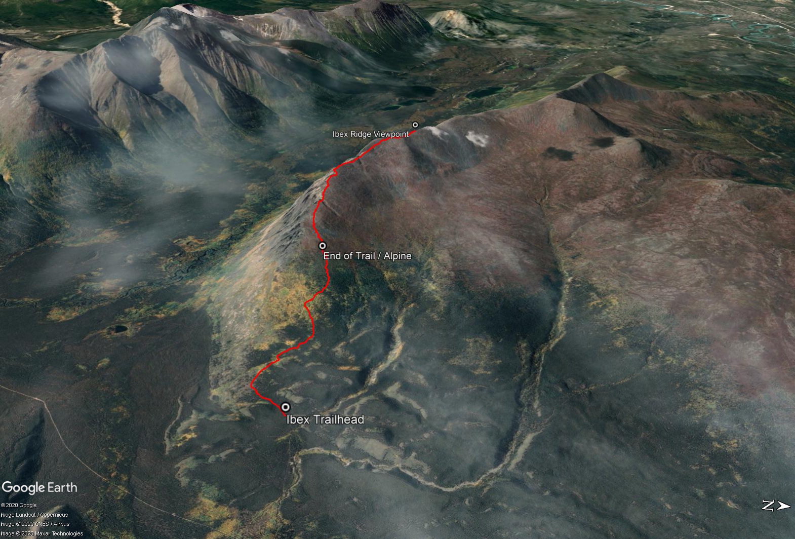
From Whitehorse drive north on the Alaska Highway. Approximately 11 km past the North Klondike Highway junction look for a sign for the Old Alaska Highway (Mile 934-929) on the left. This will be the second entrance to the Old Alaska Highway (Mile 934-929). Follow this road for 2.3 km and take a right on Scout Lake Road (a less maintained road). You will follow the Scout Lake Road for a total of 8.0 km. There are some rougher and rutted sections of the road, so a vehicle with good clearance is an absolute must.
Note watching your odometer and having a GPS are very useful, as this area has many side roads and trails off the main road. For example, you will pass a road down to Scout Lake at KM 3.6 of the Scout Lake Road (on the left) and another road down to Cub Lake at KM 5.7 (on the left), and yet another road to a small lake at KM 7.6 (on the left).
At KM 8.0, you will take a right onto rougher road. Stay on this road for just over 1 km, sticking to the main road, ignoring any side roads and keep left at any major intersections with other roads. Eventually the road will come to an end, where the trail starts. There is enough room to park and turn around.
This mountain is unnamed so we are referring to it as Ibex Ridge due to its location over the Ibex Valley. This is not Ibex Mountain, which is located 25 km to the south within the headwaters of the Ibex River.
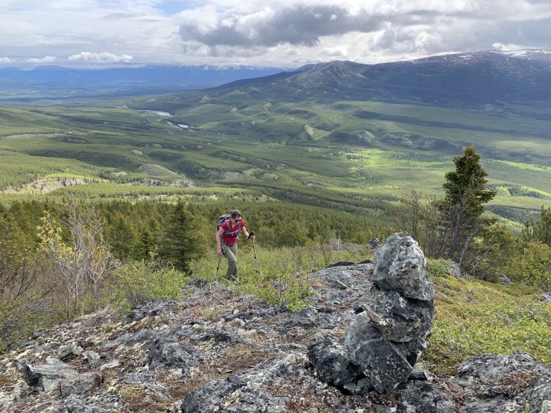
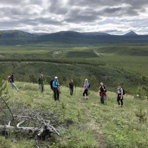
From the end of the road, head southwest for a short moment to an open meadow. There is a faint trail through the meadow, that heads across the slope and then eventually uphill and more northwest. Watch for the odd rock cairn along the way. Once you near a massive boulder, you will find a more well-defined trail through the trees.
The trail is easy to follow once in the trees and there are rock cairns and wooden posts marking the way all the way to the alpine. It is still a steep trail but no real bushwhacking. It is about 2.2 km from the trailhead until the alpine, with nearly 500 m of elevation gain.
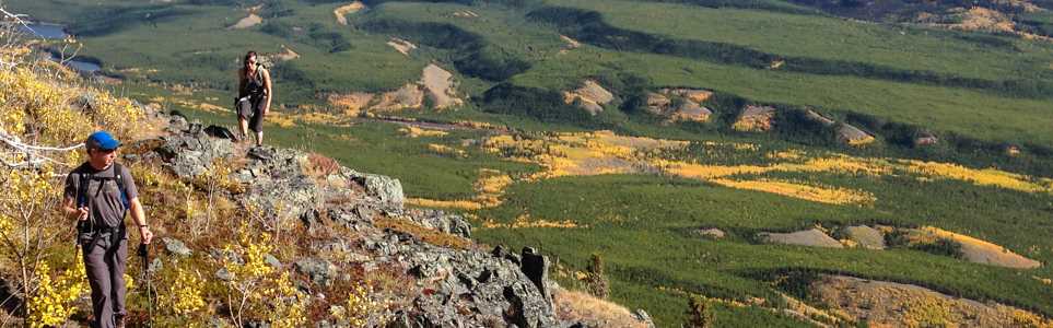
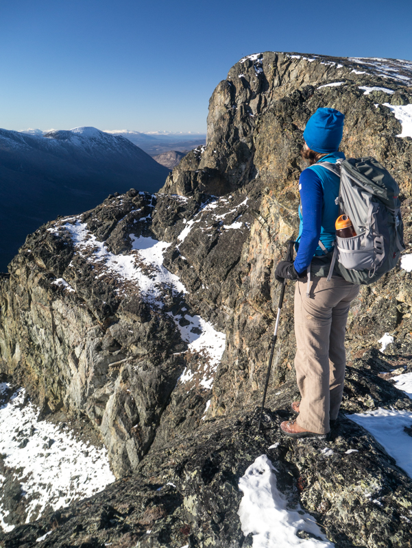
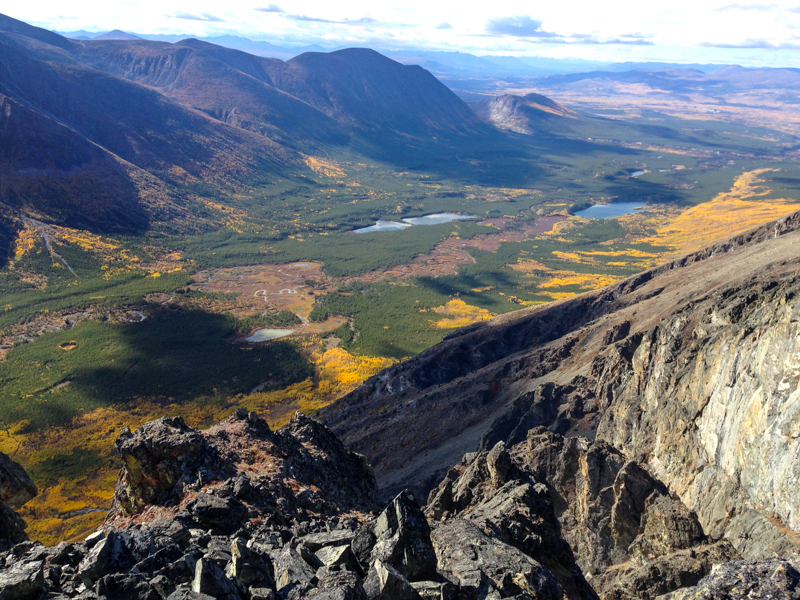
Once in the alpine, after a final wooden post, there is no longer a well-defined trial. You will see a rocky, partly-vegetated slope up to the ridge. Pick your way up, avoiding as much bushwhacking as possible. Once above this, you are on an open ridge and it is much more gradual elevation gain. You will get your first of many spectacular views over the dramatic south face of the mountain and across the Ibex River Valley over to Mount Ingram. You will want to go higher and higher as each new viewpoint offers another spectacular rock face and evermore views down the Ibex River Valley.
Watch for Dall sheep in the area and keep any dogs under control. The ridge continues for many kilometers, but the route described here to the 'Ridge Viewpoint' provides a good amount of hiking with rewarding views. The viewpoint is 2.4 km short of the main mountain summit, which requires a 100 m descent and then a further ascent up to the summit. We recommend that you take the same route back regardless of how far you go on the ridge.
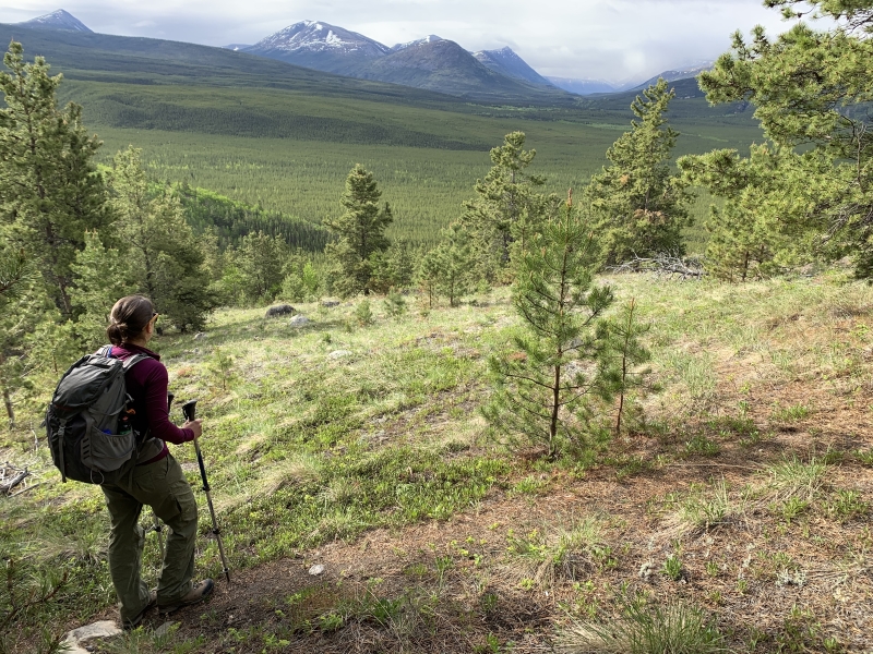
Reaching the meadow just after the trailhead.
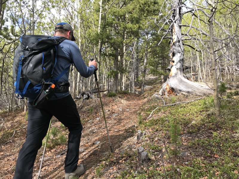
The trail is easy to follow and takes you up and through the forest.
Gaining some elevation with views back towards Scout Lake. There are some rock cairns and wooden posts to mark the trail.
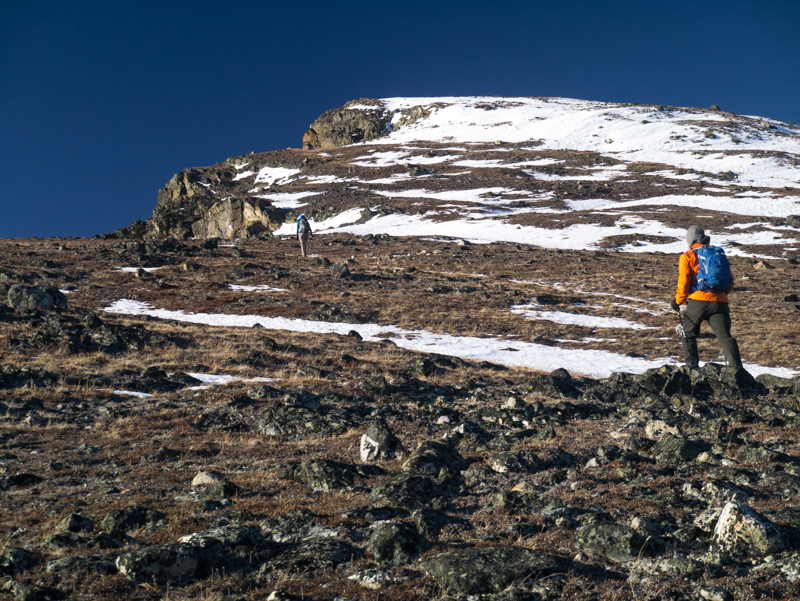
The elevation gain mellows out a little once in the alpine. Now it's as simple as following the edge of the ridge.
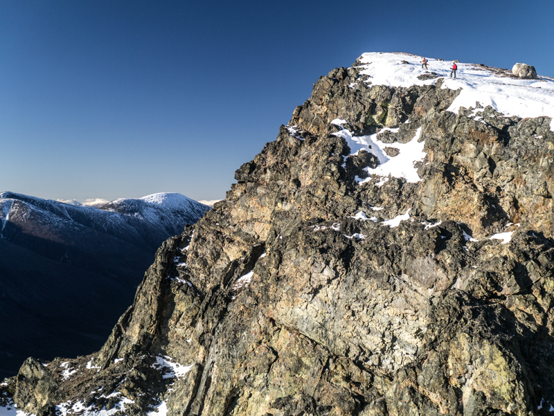
The scale of the rocky cliffs are truly spectacular and unlike any other hikes in the Whitehorse area.
Another dramatic view of another rocky cliff. Make sure to watch for sheep below.
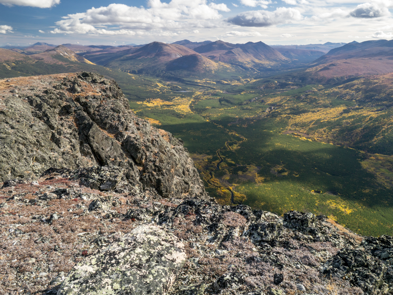
The view west, looking down the Ibex Valley. The fall is a really dramatic time to check out the area.
The view from the 'Ridge Viewpoint' looking up the Ibex River Valley.
Nissa August 29, 2025
August 28 2025: More of a fitness hike I'd say as it's short and steep. Easy trail to follow. No signs of wildlife other than seeing some mountain goats in the alpine. 4x4 needed to get to the trailhead, saw a couple cars parked much further back. If able to drive all the way to the last parking area before the trail goes into the forest, then it's only 6.6km round trip (took me 3hrs total).

ABC August 24, 2025
Hiked August 23/25. The access road is rutted and rocky, but passable in an SUV. This trail is well marked along the way, especially as you get closer to the top. It's a steady uphill but the views make it worth it! We didn't see any animals but there was some bear scat.
Ree May 19, 2025
Hiked May 18 - still discontinuous snow patches in the alpine but the summit is totally accessible. Hiking poles and cleats/crampons are helpful while the snow lasts.
The access road is totally dried out but fairly deep ruts and rocky sections. I sometimes park near Scout Lake, bike in and lock the bike around the trail head. Can go about the same speed on a bike as a vehicle on that road and much less wear-n-tear on a vehicle ;)
Marko May 3, 2025
There is still quite a bit of snow in the alpine, but we were able to make it to the summit and bad without too much difficulty.

LB June 17, 2024
Hiked on June 17, 2023. Road in ok shape if you have a truck or other high clearance vehicle and go slow, but we also biked in about 4km from the trailhead just for fun and to go faster! The trail is easy to follow through the trees and really well marked with red/white posts once out of the trees. The hike is a steady steep uphill! We saw some sheep before the viewpoint where Yukonhiking suggests stopping/turning around, and opted to not go farther up to respect them, so didn’t get to the top.
Keith Cruz October 14, 2023
When a Yukoner says "There are some rougher and rutted sections of the road, so a vehicle with good clearance is nice to have," what they mean is: rutted roads, so have a vehicle with good clearance i.e. an SUV at minimum or better yet, a truck you have to climb onto. My fellow southerners (looking at you Torontonians in particular), "rutted road" is not merely an inconvenience. This isn't like potholes in Spadina, deep and rutted as they may be. It is positively a road where your Honda Civic will not make. Forget "car might take a beating"....no, my friends, car will get stuck in the mud. Roads so bad that a sedan will give up on kind of drama.
Hiked this October 14, 2023. Terrific views, like everyone said, but be prepared to leave your car farther from the trailhead and add time accordingly. You have been warned regarding the road getting there.
Julia June 18, 2023
Fire trail
CM June 13, 2023
This hike is a (not so) hidden gem on this website! Truly very different from other hikes in Whitehorse area - you gain a lot of height, see incredible views, and the ridge itself has epic rock cliffs to one side that are also stunning. I was really surprised by how cool this hike was. The"trailhead" is right at the base of the mountain and the whole hike is consistently steep uphill, hence the difficult rating I assume. There are switchbacks but little to no flat areas so if its raining it could be a slippery adventure. The craziest part about this hike isnt even the views or that its close to town, its that is is marked the whole way to the top. I have never done a hike in the Yukon that has been this easy to follow. The hardest part of this hike is perhaps getting all the way to the trailhead that is suggested on this website. Our odometer is the only way we knew when to keep going and when to turn etc. There are so many random connecting roads and no signs whatsoever. We made a few mistakes- we accidentally took the wrong turn to scout lake instead of staying right and continuing down the road, a mistake that would of been avoided if I had read the Yukon Hiking Description better. Later on, we parked in an area (around 7.7 km) that we thought was the parking spot for the trail head. Again, had I paid more attention to the Yukon HIking description I would of kept driving down the road (which at this point was more like a dirt quad trail) and taken a right down an even sketchier road/trail, and stayed on it for another km. That extra km brings you right to the base of the mountain. Anyways, no harm, we simply just added 2 km to our overall hike lol. Would not advise taking a car on this adventure, it probably won't make it. We saw alot of moose and sheep poop, three hikers, and using binos we saw a moose crossing the river at the bottom of the valley. Great hike.
Lisa Gallibois September 12, 2022
Found a HH sweatshirt Sept 11 on the trail. Reach out if it’s yours.
Michael Reynolds June 5, 2022
Hiked to the edge of the Alpine on June 4th where I lost my red iphone. If you find it please email mer@northwestel.net.
Trail was good and is now very well marked. Still some snow patches which you have to walk through, but those will likely be gone in a few days.
Lots of moose poop on the trail up, but we didn't see any bear sign.
A beautiful, vigorous day-hike!
meredith September 2, 2021
Great hike with incredible views at the top. The road in gets pretty dodgy for the last few Km. I don't think I'd want to do it in a car without high clearance. If you are using maps and siri for driving directions she tells you to park 200m too far along the scout lake road and then to walk to the trailhead. I would recommend setting the odo on scout lake for 8.0km and then turn right onto a road that gets you right to the trailhead. This final 1km road is no worse than the scout lake road and might even be in better shape. The route up is VERY well marked. Just remember how to hit the trail coming back down.
Pippa October 4, 2020
Great hike! Thanks to Kate for the very helpful flagging. We clocked 8km from Scout Lake Rd to the turnoff. Also noted highway sign for second entrance to Old AK Hwy says "Mile 934-929", not the reverse. Drive in is challenging - high clearance essential. Nice trail but easy to miss on the way down if you aren't careful. We will take GPS or map/compass next time as we ended up bushwhacking the entire way down and out to the road in order to get back to the car.
Glenda August 8, 2020
Add us to the list of people that had trouble finding the trailhead! We clocked 8.2 kms, not 7.7 from the turn onto Scout Lake Road. If you reach a distinct very rough section of rockfall on the road, you're almost there--just go a few hundred metres more to the final road segment. We saw a few people parked at that rough spot, but you can drive all the way to the trailhead in a low clearance vehicle.
Mike Pare/ Joanne Pare June 27, 2020
Fun, grunt of a hike. Getting to the trail head is as much of an adventure as the hike is. Some kind fellow hikers we met today have flagged the right hand turn with orange and blue flagging tape. The trip up that rough little road is closer to two km. From there the trail is well marked as described with carins and some orange flags.
Kate June 27, 2020
We hiked Ibex Ridge this morning. We found the driving and trail instructions to be accurate, but heard from quite a few groups that we passed on the way down that they found it hard to find, so we added some flagging tape on our way out.
At the turn off of Scout Lake Road around 7.7 km, we added blue and orange flagging tape (used a combo because we had seen orange tape on the way in). Once you've turned off Scout Lake Road, our odometer showed approximately 1.5 km to the place where the road ends. We only saw one confusing intersection along this side road and flagged the proper fork with blue and orange flagging tape. From where we parked, we also marked the way into the meadow with orange flagging tape.
We loved the hike - we had tried the route a few years ago and found this much easier than the former bushwhacking. We didn't need the cairns much on the way up, but found them very helpful on the way down.
We dawdled along the ridge, checking out various view points. Our favourites were some of the early ones, so if you make the ridge and don't feel like pressing on, don't worry too much! We were four hours round trip.
Sylvie June 24, 2020
A group of us hiked this trial in June 2020. We had some issues finding the trailhead, in part because we were relying on an app that took us to the « old » trail head. We ended up bushwhacking for awhile before finding the actual start of the trail. 😂 The directions on here were pretty spot-on once we figured it out. The attached photo is of the meadow at the beginning of the trail.
This hike is a good workout, but the trail is not unpleasant to hike - not a lot of rock scrambles or anything. It’s appropriate for dogs, though you’ll definitely want to keep them on leash once you reach the ridge.
We took our time and had a nice leisurely lunch, and the hike took us about 9 hours up and down. The view was definitely worth it.
Antje June 13, 2020
Can anyone confirm if this is close to the beginning of the trail? I had trouble finding it but stumbled upon this bit that was the only obvious part of the trail when it was time to go home.