Total Distance: 14 km
Return Time: 3.5 hours
Elevation Gain: 215 m
Difficulty: Easy
Region: Kluane
Traditional Territory: CAFN
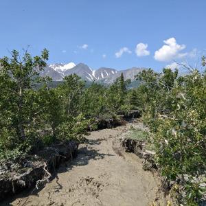
UPDATE 2022 - THIS ROUTE HAS BEEN WASHED OUT - See Route Comments below.
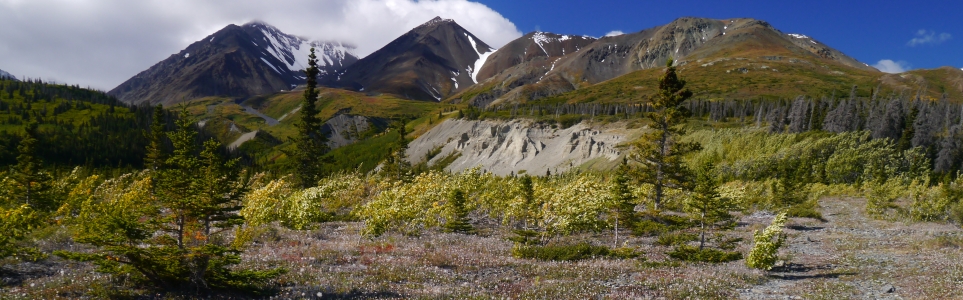
Thunderegg Creek is a nice, short hike in Kluane, which follows along an old exploration road with open views of the Alsek Valley and surrounding mountains. There is not much elevation gain as you hike through stunted stands of aspen and balsam poplar, ending up near the base of a large cutbank of Thunderegg Creek, which holds the famous 'thundereggs' (the sphere-shaped rocks) this area is known for.
From Haines Junction, continue north on the Alaska Highway for 10.5 km. Take the left immediately before the Bear Creek Lodge. Note there is a Kluane National Park sign 2 km before this turnoff that mentions the Alsek Trail. Follow this road for about 750 m until you reach a large parking area and some Parks Canada signage for the Alsek Trail. This is the parking area and trailhead. Some 4x4 vehicles may continue past this point but creek crossings may be required. You can shave off a lot of time if you drive further.
UPDATE 2022 - THIS ROUTE HAS BEEN WASHED OUT AND THE DESCRIPTION BELOW NO LONGER APPLIES. See Recent Route Comments for details.
Note: This hike is within the Kluane Wildlife Sanctuary, not within the National Park & Reserve.
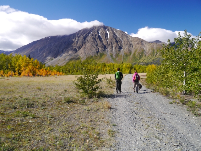
From the trailhead follow the gravel road that leads southwest from the parking lot towards the large expanse of the Alsek Valley. The road starts through a short section of trees and continues through a series of open fields and poplar stands. Follow this main road for 2.5 km until you reach a fork in the road, where a rougher road leads to the northwest (right). Follow this road for the remaining 4.2 km, which travels through an old, broad floodplain with stunted balsam poplar trees. The sightlines are not great in this area with all the low growing trees and shrubs so it is important to make noise so bears can avoid running into you.
The road ends at a large silt cliff with many good picnic spots to choose from. Thunderegg Creek is through the bushes on the left, but the real attraction is the cliffs themselves as they hold the thundereggs, which are also laying strewn around the base. The views from the cliffs are beautiful looking over the Alsek Valley, Auriol Range and Mount Archibald. Please do not take thundereggs home with you as souvenirs, so that everyone who visits this place in the future can enjoy them. Return the way you came.
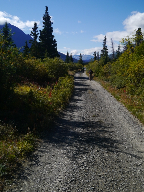
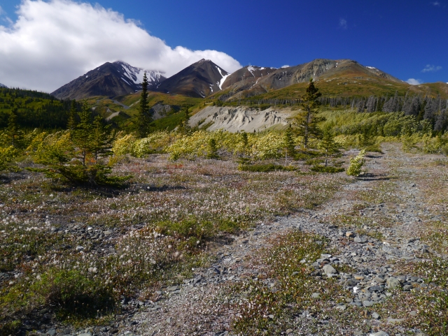
The trail starts out from the parking lot as a well-travelled gravel road.
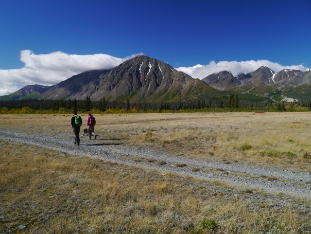
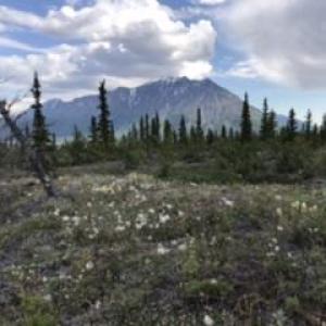
Views of the Alsek Valley and the surrounding mountains of the Kluane Range.
Following the right fork in the road to the northwest.

The trail becomes rougher as it travels through an old floodplain of stunted balsam poplar trees.
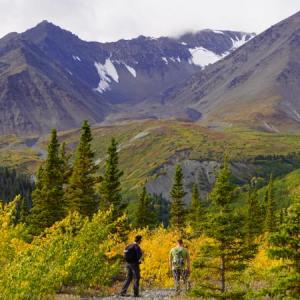
Approaching the large silt cutbank of Thunderegg Creek, with Mount Archibald behind clouds in the background.
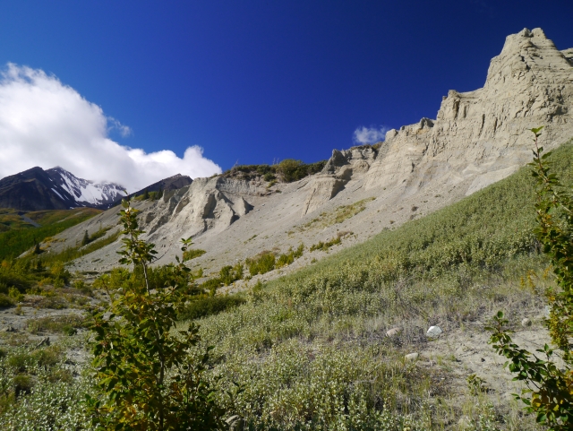
The silt cutbank of Thunderegg Creek.
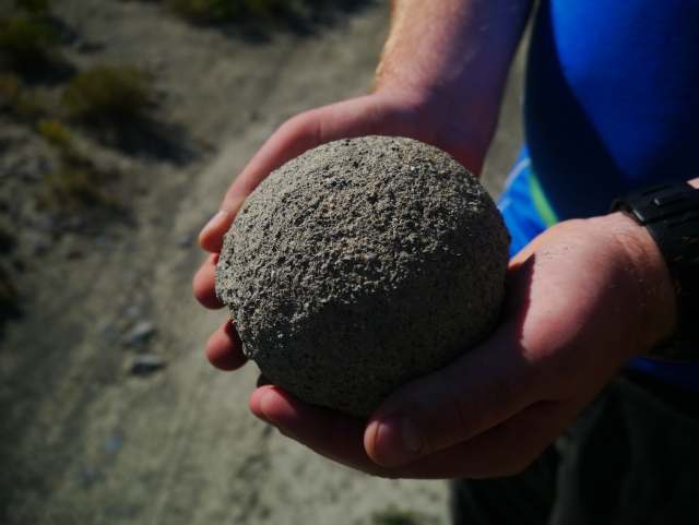
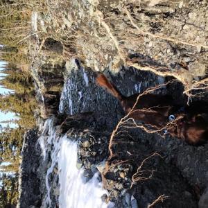
A thunderegg in hand.
Thundereggs on display.
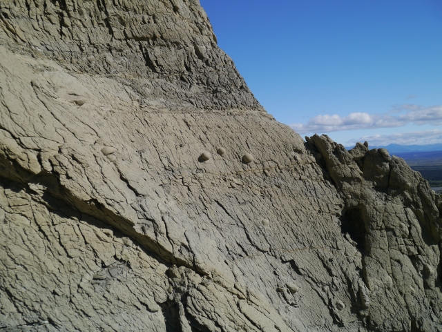
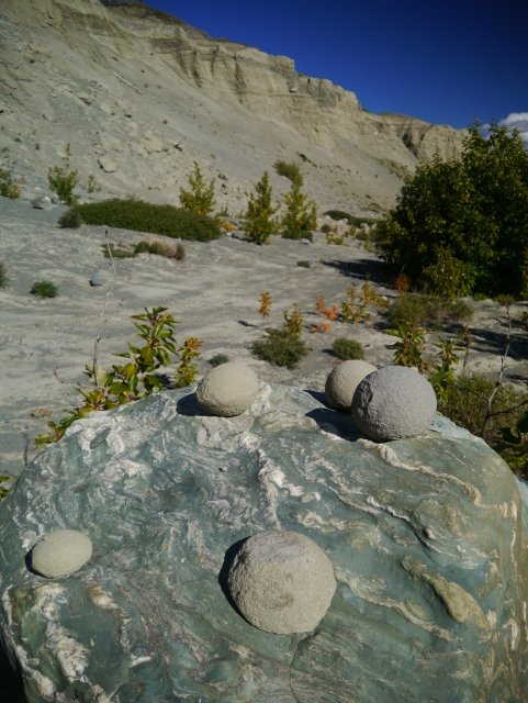
Thundereggs embedded in the silt cliffs.
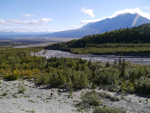
The views from the cliffs looking southeast towards the Alsek Valley and the Auriol Range with Mount Martha Black.
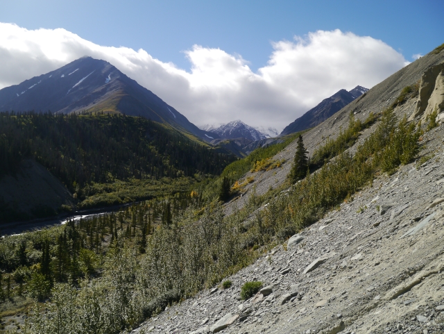
Looking west from the cliffs up to the headwaters of Thunderegg Creek and Mount Archibald.

Martin July 13, 2025
Defintately possible to hike this trail again. The flooded areas at around 1km are fitted with wood „bridges“ to cross. When it comes to km 3-5 I highly recommend to use the provided GPS track, as the way is otherwise hard to find. As mentioned in the post before: Proper footwear is highly advisable to the rocky path. Enjoyed the hike and would recommend! In and out in a little less than 3 hours…

Leah S May 4, 2025
We hiked this May 3rd, 2025.
It was beautiful! The washout is impressive to see but no problems walking around or through it. Still some snow & mud patches but not much.
The trail will make you feel like you’ve worked harder than it is because if the rocks and instability. Def wear ankle boots!
Recommended for sure. The eggs are so neat and the views spectacular. Expect lots of wind walking in that valley.

Jenn April 21, 2025
We just hiked Thunderegg Creek in Easter weekend. There was very little running water and none in the washout. It was almost snow free. When we did meet snow it was deep - to our waists but short lived about 200m of it.
Tom August 4, 2022
Hiked this on July 21st; I second CM's comments. We did less bushwacking, but more creek crossings. In my opinion, this hike is not worth the difficulty.
Be aware: the dry streambed we followed on the way in was in full flow on the way out 3 hours later.
CM July 15, 2022
*** To clarify something in my original comment below, when I say " The bushwacking starts at the beginning of the hike" I am referring to the turn OFF of the alsek trail onto the thunderegg creek bed as the "beginning" of the hike. You can still get down the alsek valley trail (although some parts were also a bit flooded when we were there), but once you turn and start walking down the creek bed towards thunderegg creek, the bushwacking begins :)
CM July 15, 2022
Hiked all the way into thunderegg creek on July 8. Can confirm what was said in the previous comments: the original thunderegg creek hike no longer exists, almost all of the trail is now a river bed.
New "route" requires an hour or so of bushwhacking on the RIGHT side of the creek going in (left going out). If you stay on the right side of the creek you will be able to eventually hit what is remaining of the old thunderegg creek trail. The bushwacking starts at the beginning of the hike in and shouldn't last more than 1.5 hours. The brush is thick but many people are starting to take similar routes, creating a severely overgrown "trail?" sortof?
If you choose to bushwack to the end and dont have super great navigation skills: the landscape is changing drastically everyday and new side streams are branching out, so you can't rely solely on walking right next to the creek.
If you do the bushwacking on the RIGHT side of the creek you do not remain next to the creek throughout the whole duration of the bushwack. You are constantly poking in and out of the woods, sometimes walking right next to the creek, sometimes off in the woods 100 meters away from the creek and can just hear it running. This is also all dependant on the water levels and new erosion (we hiked in July 8 and out July 10 and on the way out the water had receded in some places and rose in others).
On the plus- Thunderegg creek is quieter these days ! Was nice once we got to our end point :)
HS July 3, 2022
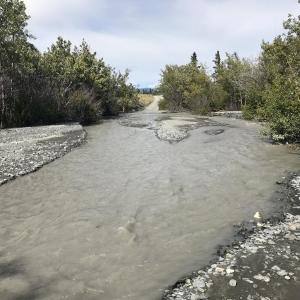
From the previous 2021 comments, we were expecting high water levels and a washed out road, but it is difficult to understate how much the trail has been washed out and altered by the river (and presumably large snowfalls / melt).
After the fork in the road (on the rougher road from the Alsek valley trail) about 200m in, the road is completely washed out. There is limited bank to hike on, we even watched one bank cave in to the stream, so we bushwacked for about 1.5 km. We ended up finding the road briefly (see photo), and realized that the stream has nearly entirely over taken the old road.
After a couple of hours with exhausting bushwacking, we turned around without making it to the cliffs.
If you are going this summer, be prepared for a more difficult / strenuous hike with constant bushwacking, trail breaking and route finding.
Elsabe Kloppers October 19, 2021
October 17, 2021
Having not hiked this trail in a few years, I was shocked at how much it had changed with the heavy snowloads and rainfall of this past year. The creek had washed out most of what was the old road. If the ground and creek weren't frozen now, it would have been challenging travel for the lower 2/3 of it. We paid attention in the lower end for where the trail went as the creek has washed through the bushes everywhere. We walked inside the rutted walls (see photo), and picked our way around the edges, and hopped over the frozen ice sections. The upper third was much better away from the creek, and we got into ankle-deep snow. Thundereggs were still calving and running down the slope on warm days like today. Beautiful hike and day exploring. Older Grizzly prints seen in the muddy trail.
Alice September 6, 2021
get ready for an adventure y'all. Trail washouts a plenty this year... easy to lose the trail heading up. doable, but no walk in the park anymore.
El Trio June 30, 2021
Attempted this hike on June 29th 2021 thinking it would be an easy one to do before heading back home. However we were met with swarms of mosquitoes (literally thousands around us) and many quick overflowing, silty, slippery creek crossings that spanned over a hundred meters through the forest. The evidence of last winters huge snow loads are going to leave this trail forever changed! If you decide to attempt this trail in the next couple weeks, bring poles to help with creeks crossings, good shoes, and a bug suit! We turned back atfer about 4 km in.
er-egg creek had flowed over its banks. There were many braids of silty water -often knee deep. For a couple of hundred meters, the stream eroded impassable deep trenches of fast moving into the track, easy bushwacking around these sectio
JB August 20, 2020
August 17, 2020 - we thought this would be an easy, rainy day trail (after a very rainy long weekend). We were in for a Kluane surprise! The inital two streams were fast moving, knee deep and silty (board walks 1/3 across creek). At the trails junction, water was moving everywhere - regardless, we were familiar with the route, hiking onward. Thunder-egg creek had flowed over its banks. There were many braids of silty water -often knee deep. For a couple of hundred meters, the stream eroded impassable deep trenches of fast moving into the track, easy bushwacking around these sections. The last couple of kilometers were free of water. Has the Thunder-Hen moved her creek? After water levels subside we will know...
Dana August 19, 2020
Biked this trail this weekend, a bumpy ride but lots of fun! Be prepared to get your feet wet though... The creek has taken over the trail in many places, requiring numerous creek crossings to get to the end. The deepest point we crossed was about knee high, most areas were just ankle to mid-calf deep. The water has carved out the trail pretty badly too, at some points we had to break trail through the shrubs because there was nothing left of the road. It's a bit more of an adventure than previous years, but still worth the trip!
Danielle July 4, 2020
Hiked this trail today. Like the previous commenter, we also had to cross a third stream- the water is about ankle deep! Otherwise the trail was easy to follow, great views, and the thundereggs are pretty cool. There was some fresh bear scat but no other signs or sightings. Would definitely hike this trail again!
KP June 22, 2020
Fun, quick hike with some nice views along the way. I did this June 21st, 2020. To note, beyond the first two actual streams with the boards for crossing, there was a network of smaller streams maybe a couple kilometers later where I did not see any boards to cross. Most of them I was able to step over or jump across, and for the one that I couldn't, I found some dead trees to use as a makeshift bridge. I don't know if these streams are a permanent feature of the area or a consequence of some early summer melting.
Jean August 25, 2019
Trail was great! The two creeks to cross have boards to walk on. Trail is easy to find and follow. Keep to the right at the fork and keep going. Bear scat in a few places and noticed prints in one place but didn't see any bears. Met 2 people close to the trail head who had been mountain biking in the area. When we were coming down, we met three other groups of two. Round trip it was 14 km and took us 4 hours including stopping to talk with other hikers and a break at the top.
Liz B September 1, 2018
Hiked Thunderegg Creek today (September 1). Two small creeks to get past at the beginning of the trail but people have created "bridges" out of logs so they're easy to cross. As others have mentioned the trailhead is shared with the Alsek River trail so stick to the right when the trail forks. The fork is very obvious, just pay attention and you shouldn't miss it.
Easy trail with a gradual incline. Pretty rocky in some spots so you need watch your footing. The hike ends at the cliffs with the thundereggs. All in all a great day hike!
Julie and David August 5, 2018
We hiked this trail Aug 4. The creek was high - about 10" (25 cm) at the highest point so water shoes were definitely needed.
The trail starts at the same trailhead as the Alsek River Valley Trail. There is a trail marker at the 2.5 km point. Once you pass this marker, it's about a 7 or 8 minute walk to the fork where the trails diverge. Take the right hand fork and follow this trail (an ATV road) until it ends at the large cliff.
Lots of interesting rocks in the area including the thundereggs, which are actually concretions, not thundereggs - see this article - http://www.explorenorth.com/library/mining/bl-concretions.htm
Enjoy!
Julie
Jackie July 14, 2018
Did this July 8. There is a creek crossing not too far from the parking lot. The water is ice-cold but only got to ankle height. A wood plank was placed over a part of the creek that dips a little deeper, but that part is easily avoided.
Thought the "fork" mentioned in the comments was fairly obvious - it's the only clear pathway that branches off from the main trail on the right, and it looks like there's been ATV activity on it. Someone has seemingly left a very short log with a + dug into it as a marker of some sort right at the fork.
The path through the riverbed/floodplain can seem to randomly disappear at points, but when in doubt, stick to the RIGHT.
We saw fresh bear poop on the trail leading from the riverbed to the actual thunderegg site. A group hiking ahead of us that day also encountered a black bear near the parking lot area.
Matt August 6, 2017
Had a great time on this hike today. Just wanted to share a few impressions/notes if it helps anyone else. There is a creek crossing that many commenters have mentioned but isn't in the official trail description. This is about .7K or so in (pictured). The next interesting bit is that there's an official trail sign indicating 2.5K, which is actually about 1.7K from the parking spot, so don't get this confused with the 2.5K fork in the road, which is accurately at 2.5K from the parking lot. The fork itself doesn't really look like much of a fork, so much as a smaller, more worn out trail that peels off to the right. Take the trail that heads right (which is northwest). That trail turns into a riverbed ATV trail that is quite washed out in places. We missed the turn to connect back with the formal trail, but managed to re-connect with it. To not miss it, I would advise sticking generally to the right while in this riverbed section. Finally, the 4.2K from the fork to the thundereggs is an easy gradual incline, but it's worth noting that it is quite rocky virtually the whole way so it's a test of your ankles and unfortunately forces you to look down a bit more than you'd like. Soaking in the scenery for too long risks a stumble or two! Still a fun hike with an interesting destination so well worth it. We managed 3 hours 50 minutes including a 20-25 minute lunch up top.
Mabel May 17, 2017
We did this hike on May 13th. The weather wasn't great starting out but it cleared up a lot as we progressed. The creek crossing was slightly challenging but doable. Just a heads up, we found the fork in the road confusing (mainly because we were trying to remember the map and we didn't have a compass with us) so to be clear, take the path going to the right! We went left because we thought that path looked "rougher". We kept going under we reached the entrance to Kluane National Park and realized that we had definitely taken the wrong path. It was still a beautiful hike and we saw some thundereggs at the fork in the road but would love to redo it someday and actually make it to the proper destination!
Nichole July 29, 2016
Did the Thunderegg Creek Trail July 24, 2016 and found the initial creek crossing, about 1 km down the trail, very different than when I was there in fall 2015. Last year there was a board used to cross this creek, however, the creek was now flooded with no easy way to cross. We removed boots and carefully forded the very cold creek. Upon reaching the floodplain portion of the hike we discovered water flowing through, where none had been last fall. We stuck to the right side of the water heading up and managed to find the trail again fairly easily after passing the floodplain.
Voyageur March 19, 2016
Skied Thunderegg Trail on March 18 with about 5 cm of fresh snow on the tracks. Trail is flat till the turnoff to the Alsek River, then slightly uphill. We had lunch at the end of the trail, close to the river which was not frozen. It took us 1,5 hr. to ski up to the river and 1 hr. to ski back down. Due to low temps the snow was sticky in lower elevations. Scenery is great with changing vegetation, views were limited since it was snowing most of the day.
GREAT trip for an easy day on x-country skies!
Alastair Cook August 18, 2015
On August 16th a small group of us went out on this trail, on a glorious late summer day. My five year old grandson was one of the group, plus other family members. We made it all the way to the Thunder eggs at the end of the trail, which was a source of amazement to us all, especially my grandson, who later declared this to be the best day of his life. The trail is essentially a gravelled road all the way, and hence very easy to follow. The scenery is intoxicating, and why I've never done this hike before in my 35 years in the Yukon is a mystery. This is totally recommended to everyone, of all ages, as our hike proved. It ranks among the very best day-out hikes I've ever been on.
