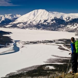
Carcross
Distance: 11 km
Elevation Gain: 901 m (2956 ft)
Time: 6.5 hours
Difficulty: Difficult
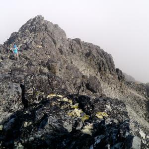
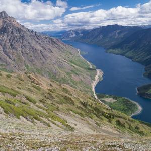
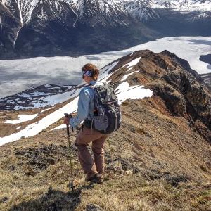
Brute Mountain is an exciting and challenging hike up to a rocky peak with sweeping views over Bennett Lake, Montana Mountain and Carcross.
Elevation Gain: 901 m (2956 ft)
Time: 6.5 hours
Difficulty: Difficult
Brute Mountain is an exciting and challenging hike up to a rocky peak with sweeping views over Bennett Lake, Montana Mountain and Carcross.
Distance: 8 km
Elevation Gain: 1000 m (3281 ft)
Time: 4-5 hours
Difficulty: Moderate
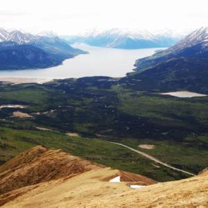
This hike is steep and to the point. Before long you are rewarded with a view of Bennett Lake, nestled between mountain peaks. The alpine ridge is a pleasure to climb. Please avoid hiking this trail from April 1st to June 15th to avoid disturbing the sheep during lambing season.
Elevation Gain: 1000 m (3281 ft)
Time: 4-5 hours
Difficulty: Moderate
This hike is steep and to the point. Before long you are rewarded with a view of Bennett Lake, nestled between mountain peaks. The alpine ridge is a pleasure to climb. Please avoid hiking this trail from April 1st to June 15th to avoid disturbing the sheep during lambing season.
Distance: 8 km
Elevation Gain: 1272 m (4173 ft)
Time: 6.5 hours
Difficulty: Difficult
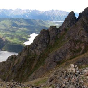
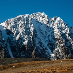
Dail Peak, named after miner George Dail, offers sweeping views down the Klondike Highway above Windy Arm of Tagish Lake. It is connected via a ridge system to Mount Matheson and eventually to Montana Mountain. It is the home of numerous Dall sheep and mountain goats. From the top of the ridge, there are tremendous views of the surrounding area.
Elevation Gain: 1272 m (4173 ft)
Time: 6.5 hours
Difficulty: Difficult
Dail Peak, named after miner George Dail, offers sweeping views down the Klondike Highway above Windy Arm of Tagish Lake. It is connected via a ridge system to Mount Matheson and eventually to Montana Mountain. It is the home of numerous Dall sheep and mountain goats. From the top of the ridge, there are tremendous views of the surrounding area.
Distance: 15 km
Elevation Gain: 853 m (2799 ft)
Time: 5.5 hours
Difficulty: Moderate
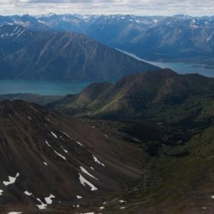
The Montana plateau is a great area to explore, and Montana Mountain is the highest peak on the Montana massif. It isn't a difficult hike, but you need a vehicle with a little bit of clearance (even a car that doesn't sit too low is fine). Most of the hike is above the tree line and the views are always pleasant. The view from the summit and the ridge are fantastic, opening up an ocean of mountain tops in all directions. NOTE: This hike falls within Category A Settlement Lands of the Carcross Tagish First Nation. Please respect their rules and land.
Elevation Gain: 853 m (2799 ft)
Time: 5.5 hours
Difficulty: Moderate
The Montana plateau is a great area to explore, and Montana Mountain is the highest peak on the Montana massif. It isn't a difficult hike, but you need a vehicle with a little bit of clearance (even a car that doesn't sit too low is fine). Most of the hike is above the tree line and the views are always pleasant. The view from the summit and the ridge are fantastic, opening up an ocean of mountain tops in all directions. NOTE: This hike falls within Category A Settlement Lands of the Carcross Tagish First Nation. Please respect their rules and land.
Distance: 4 km
Elevation Gain: 1055 m (3461 ft)
Time: 4.5 hours
Difficulty: Difficult
Mount Racine is a prominent peak at the south end of Tagish Lake's Windy Arm with sweeping views also over to Tutshi Lake and the surrounding mountains. The route is a direct one, straight up the main avalanche path, which is the quickest way to the top and also avoids the most bushwacking.
Distance: 8 km
Elevation Gain: 1000 m (3281 ft)
Time: 4.5 hours
Difficulty: Moderate
Nares Mountain is a beautiful hike with views over the community of Carcross and Nares and Bennett lakes. Don't be fooled by the short distance and duration for this hike, the 1000 m of elevation gain can definitely kick you into shape. Please avoid this area between April 1-June 15 due to the sheep lambing season.
Distance: 6 km
Elevation Gain: 626 m (2054 ft)
Time: 3 hours
Difficulty: Moderate
Paddy Peak is the highest mountain south of Carcross along the highway to Skagway. From the top, the views of mountain tops and the southern lakes seems endless in all directions. There is a 4x4 road from the highway that gains over 700 m of elevation, making the hike a quick scramble to the peak if you decide to drive. If you decide to hike the road, add 14 km to the distance and 3-4 hours to the hike.
Distance: 9 km
Elevation Gain: 618 m (2028 ft)
Time: 3.5 hours
Difficulty: Moderate
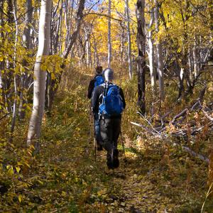
Follow this historic trail up into the alpine below Montana Mountain. The trail was originally made to service the tramway built in 1905 by Sam McGee for a silver mining operation. There are many remnants of the tramway and mining artifacts along the trail. The view from the top is fantastic, with Windy Arm of Tagish Lake below, and all of the surrounding mountains. There are a lot of deciduous trees here, so this is also a great trail to view the amazing fall colours. To extend this hike, you can connect to the Mountain Hero mountain biking trail, or hike up some of the surrounding ridges. NOTE: This hike falls within Category A Settlement Lands of the Carcross Tagish First Nation. Please respect their rules and land.
Elevation Gain: 618 m (2028 ft)
Time: 3.5 hours
Difficulty: Moderate
Follow this historic trail up into the alpine below Montana Mountain. The trail was originally made to service the tramway built in 1905 by Sam McGee for a silver mining operation. There are many remnants of the tramway and mining artifacts along the trail. The view from the top is fantastic, with Windy Arm of Tagish Lake below, and all of the surrounding mountains. There are a lot of deciduous trees here, so this is also a great trail to view the amazing fall colours. To extend this hike, you can connect to the Mountain Hero mountain biking trail, or hike up some of the surrounding ridges. NOTE: This hike falls within Category A Settlement Lands of the Carcross Tagish First Nation. Please respect their rules and land.
Distance: 9 km
Elevation Gain: 868 m (2848 ft)
Time: 5 hours
Difficulty: Difficult
This hike offers sweeping views of Tutshi Lake and the surrounding mountains. There is a lot of steep scree to climb up to the ridge but it is a fun, narrow ridge to walk once on the top. It is a favourite early-season hike as it is south facing with early snow melt. As a bonus watch for Mountain Goats on the ridge.