Total Distance: 20 km
Return Time: 7 hours
Elevation Gain: 900 m
Difficulty: Moderate
Region: Annie Lake
Traditional Territory: CTFN
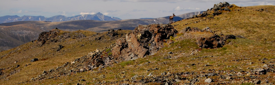
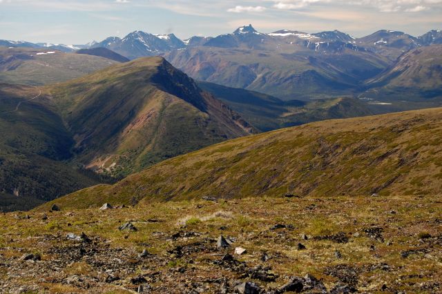
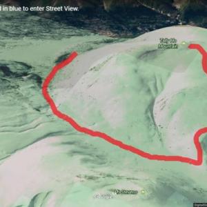
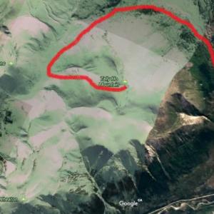
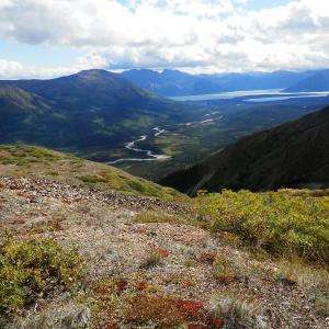
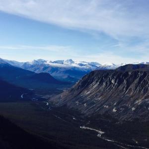
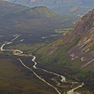
While on top of Tally-Ho mountain, you get a fantastic view down the Wheaton River Valley. The ridge around the summit is completely open alpine which makes exploring easy. It is also prime habitat for caribou, which can often be seen near the summit. The route follows an ATV trail for a lot of the way. NOTE: This hike falls within Category A Settlement Lands of the Carcross Tagish First Nation. Please respect their rules and land.
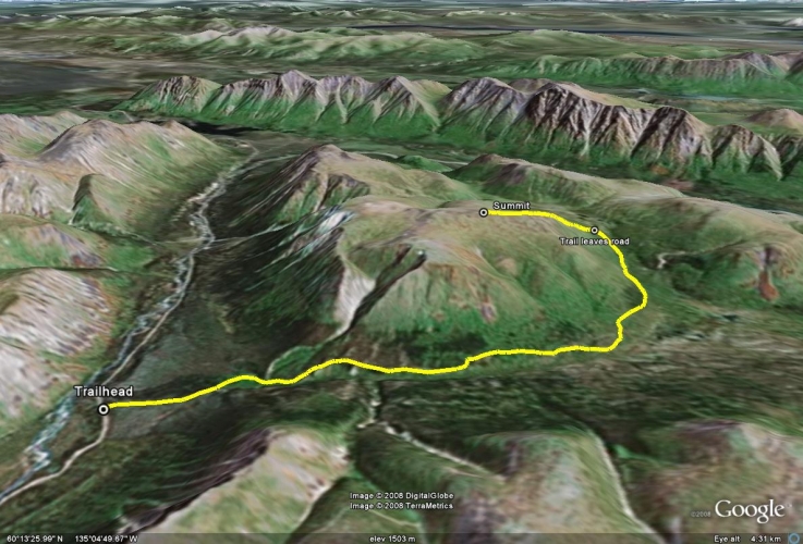
From Whitehorse, drive south on the Alaska Highway to the Carcross Cutoff and turn right onto the South Klondike Highway. Drive south for about 17 km and turn right onto the Annie Lake Road. After 26 km on the Annie Lake Road, you will cross a bridge over the Wheaton River. Around 7.9 km after the bridge, you will reach a large pullout on the left in a gravel pit with a rougher ATV road leading into the forest. This is the trailhead. Note there is a similar looking pullout with an ATV trail about 4 km after the bridge as well, but make sure you keep going to the second one on the left at 7.9 km after the bridge.
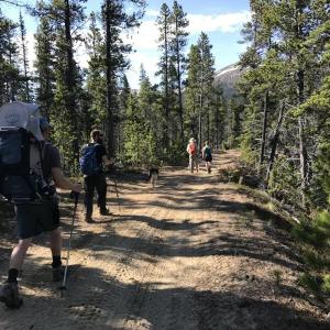
From the parking area follow the ATV road that leads southeast into the forest. This road basically takes you into the subalpine after about 8 km.
After 1 km from the trailhead you will reach a fork in the road. The right side ascends and the left side descends slightly - follow the left fork. There is a creek crossing shortly after the fork. Earlier in the season (May - June) the water can be just below your knees so you may want to bring some light creek crossing shoes.
The route continues on the road heading southeast through mostly dry, lichen covered pine forests, following along the north side of the Partridge Creek Valley. The elevation gain is gradual for the most part with many nice flat sections. There are some nice lookouts along the way, including the first view of the Montana Mountain Massif near Carcross, after about 5.5 km (this is a good turn around spot if you are looking for a shorter day hike). The road eventually curves to the northeast heading into the subalpine.
After a total of about 8 km (from the trailhead) you will leave the road and turn left, straight up the steep ridge. There is no trail to the top from here, but it is mostly alpine so you can pick your own way up. You will reach a high plateau with great views once at the top. Continue following the ridge to the summit. Watch out for caribou, hidden behind the rocks! Return the way you came up. Alternatively, instead of hiking the slope directly up the mountain, you could follow the road the longer way around, keeping left at any forks in the road.
HIKE OPTION
For a slightly different hike option, Mount Wheaton is directly east of Tally-Ho Mountain with some amazing views over the southern portion of the Wheaton River. See the route description for Mount Wheaton on the website.
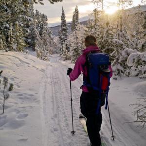
It is a nice ski or snowshoe to at least the Partridge Creek Valley lookout area in the winter - 5.5 km (one way) from the trailhead.
The area is well-used by snowmobilers in the winter, which grooms a nice trail on the road, which means less breaking trail.
Note after the road turns up the valley to the northeast, the trees thin out and the route is following below the slope of Tally-Ho, as you enter ''challenging'' avalanche terrain. The Wheaton valley is often characterized by a thin and weak snowpack. Check out the Yukon Avalanche Association website ''ATES'' maps (Avalanche Terrain Ratings) at yukonavalanche.ca/ates for more information and potential mitigation.
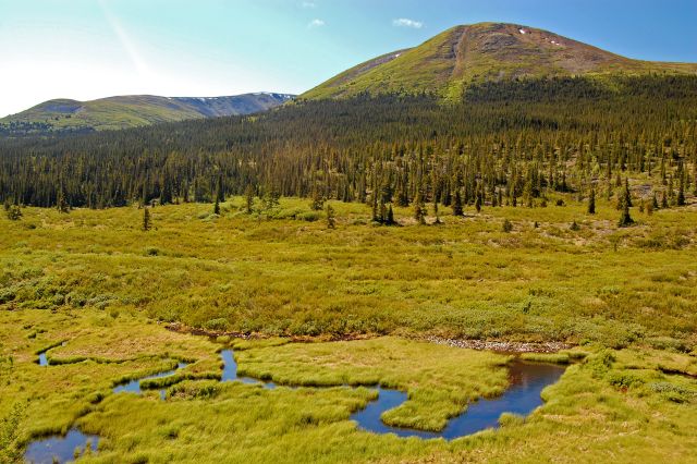
The trail/road follows along Partridge Creek.
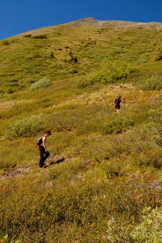
After the trail turns off from the road, its a steep ascent to the summit.
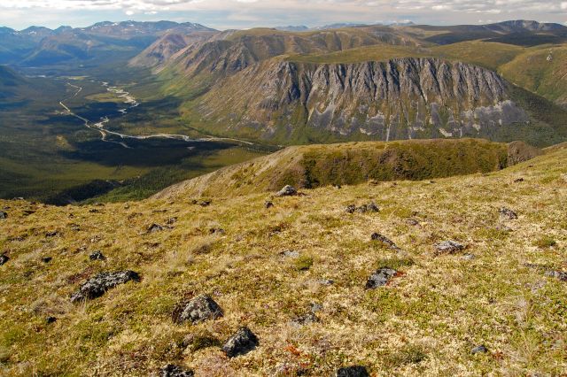
Mountain vista from the top.
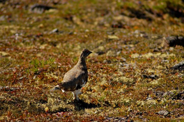
Ptarmigan running around the summit.
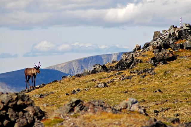
A caribou beating us to the summit marker.
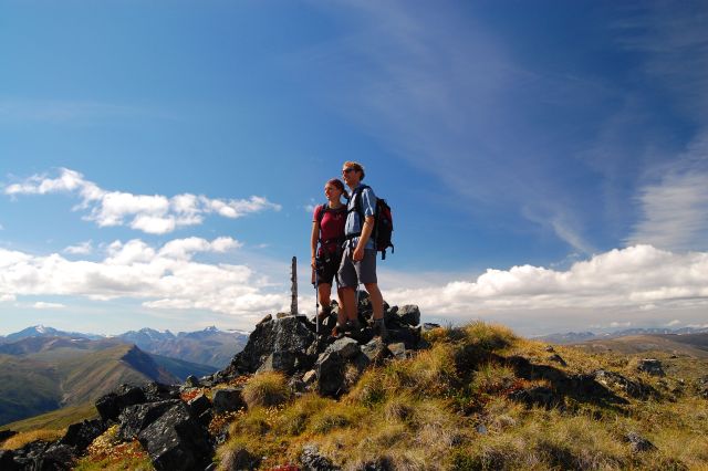
Rocking the summit after the caribou had finished.
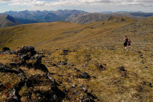
Descending onto the open alpine ridge.
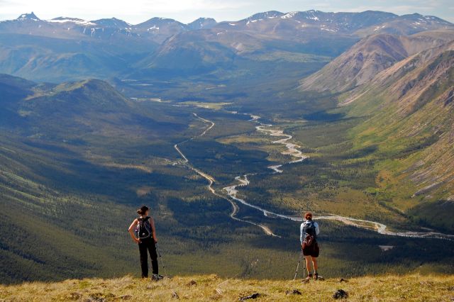
Checking out the beautiful view of Wheaton River valley.
The Wheaton River valley and Annie Lake road.
Shailyn September 23, 2024
Hiked for the first time on September 14th. I enjoyed the hike (probably more than Anderson - though the summit views from Anderson are wonderful!). But we did not summit. We saw the general area where the description said to go up. But then we had also seen that you could also take the longer route up via the road. Not knowing how much longer the road would be, we opted for that option. But it turns out the road is much much longer and we simply ran out of time. Kind of a shame and I wish we had just picked our way/bushwhacked up. Maybe that could be an addition to the description (saying how long the road is). Lovely colours and tons of bear poop, but no wildlife sightings. The creek was just above the ankle but we managed to get across on rocks and with some minor wet feet.
Rhiannon May 24, 2020
Hiked this May 23. Beautiful day, beautiful hike. We brought sandals/Crocs for the creek crossing at the start. A few big puddles on the trail but you can easily go around.
Yukon Hiker May 11, 2020
The road into the trailhead is clear and fairly easy to drive. The trail in (around 1pm) had a few spots with snow and mud/puddles, but easy to get around. There is 1 creek crossing that was above the ankle. We started the climb up the mountain a bit earlier because it was pretty snow covered if we went to the end of the trail.
On the hike back (around 6pm) the trail was much more wet and muddy. The creek crossing was about 1/2 way up the leg this time. We saw fresh bear prints (big & small).
We didn't see any caribou, but did see a big porcupine. Once you get to the top of the mountain there are spectacular 360 degree views! You can walk along the ridge as well. Warning, going up and down the mountain is VERY steep.
Kenji August 24, 2018
Biked in with the kids which really means we pushed their bikes most of the way up. We needed water and decided to go further down the road until we reached a nice creek. Camped here 2 nights. Hiked up Tally-Ho the next day and saw a couple caribou near the top. Lost a Garmin GPS somewhere on the way down while eating blueberries. Reward offered if you find it! Bike down was much better and kids had fun.
Cata July 18, 2018
Has anyone hiked this recently?
kyliestravel July 3, 2017
There was a male caribou walking about, which was really cool. And 2 foxes sussing me out on my way up. The views were amazing. From there you could see the vast number of atv (and sled) trails. I definitely want to come back here with an ATV and sled for ski touring in winter time, its a really nice bowl at the back.
I attached maps of where I went in hopes this might help others. It wasn't very steep, as it was an ATV trail. Took 7 hours in total with a nice nap by the river after!
kyliestravel July 3, 2017
Finally conquered Tally-Ho! the second pull out, following along the atv road. After the first fork, turning left. The creek at 9am was sometimes ankle deep, but shimmy across and no water got inside my boots. Follow the atv trail, it goes up occasionally, but mostly flat. After 8km, I was trying to find where the decsribed "leave road and head up alpine", with mostly a lot of shrubs. I attempted twice (wasting about 45 minutes). Trying to bush whack up got to no point, as the bushes and shrubs both times ended up too dense and taller than me!. So seeing the diagram above, unsure where the access up is supposed to be. Anyway, I decided to continue to follow the ATV trail for another km, it then splits again, take left (the right goes to mount stevens) then follow this a couple hundred metres, then from here take a left again (if follow straight on, appears to go to mount wheaton summit). Followed this up and the road ends only about 100 or so metres from the actual summit.
Yukon Hiking June 11, 2017
We updated the DRIVING DIRECTIONS and added more details to the TRAIL DESCRIPTION to avoid any further confusion. It appears some people are parking at the wrong pullout and are walking up the wrong quad trail. Make sure to start the trail at the pullout 7.9 km after the bridge!
Then just follow the road that leads from the parking area as described in the Trail Description.
The road was in great condition June 10th when we did it. Note the creek was quite high (requiring us to take our boots off) and we were following bear tracks for most of the way.
kyliestravel June 2, 2017
Interesting information. There was a section on the road past the bridge that was cleared from the slide that came down and about 200-300 metres after this was a big pullout on the left for camping and an obvious ATV trail. Followed this and nowhere along was there an obvious fork. On the left was all loose sand and rocks - I tried going up this, but no grip whatsever and the higher I would go the more dangerous of another slide.
Possible I need to break the trail up with elders in the way!? The yellow line came to a impassable waterfall - possibly once the ice melts off this, you could go this way up. I definitely want to try again- if you're interested, give me an email kyliecampbell12@gmail.com
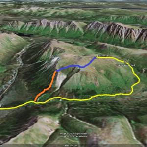
John May 29, 2017
Just so you can visualize what I did, the red line is my straight forward ascent. That's when the trail started to disappear (around KM 2) and I decided to go straight up (staying left of the valley). Blue line is the exploration at the summit. Yellow line is my way down (following the trail described here, which doesn't really exist).
John May 29, 2017
I have done this trail twice and the information on here is somewhat accurate. It is important to start the trail 6KM's after the bridge. There is a pull-out with a clear spot to park on the left side of the road. After 1KM, there is a fork in the ATV trail and you have to stay to the left. That is pretty much what is accurate. (There is not really a left that descends and a right that goes up)
After about 1 KM, the trail becomes less and less existent. So I agree with you that it has probably been washed out. However, both times I did it, I took a direct path to the summit and it wasn't too bad. Instead of following the creek all the way to the top, I just hiked straight up when the trail was getting harder to follow.
At the top, there are many options. You can explore for days on this plateau. But I just had lunch, explored a bit and came back down following the creek (or the trail described here), but it was mostly bush-wacking. And I have to agree with you again that there is not really a trail and that it can be a bit tricky with the ice and mud.
I think all 3 hikes on Annie Lake road are out of date. Mount Skukum and Red Ridge are the other ones. For both of these hikes, the trailhead actually starts many kilometres before what yukonhiking says. Bridge is still OUT for Mount Skukum, so that adds about 20 KM's to the hike (which makes it a multi-day hike for most people). And the road to Red Ridge is unpassable. That also adds many kilometres to Red Ridge when you have to park many KM's before the actual trailhead...
kyliestravel May 28, 2017
Not sure if anyone has recently done this trail, but the information is really out of date. I attempted this trail 27/5 and it wasn't passable.
Firstly, the road during the winter slid completely, it was removed from the road - so you can drive now, but it was an indication that a lot of slides had come down Tally ho - which was the case.
I camped at the pullout on the friday and started up the quad trail. After 1km, there is no fork - as listed here - I hiked about 3-4 kilometres - as far as you could go. The quad trail had a slide and about a 400m patch was just boulders from the mountain , but then after crossing the creek it was a nice quad trail again. Continuing up, you could see the mountain had slid over the winter. With the lefts slid with giant mounds of mud and loose sand and rocks. The only way up was following the creek - which had ice-glazed rocks - making it difficult to not slip.
I continued until the last point where there was a waterfall the left was sheer loose dirt and rocks and there was a large patch of snow on the waterfall.
Without saftey gear or knowing the conditions further, I had to turn back.
I had spoken with Hans (the last house at the bridge crossing), he said next time I'm back, he will take me on another trail, which goes around tally-ho on the other side! So will update when this gets done.
But I think the trail has been washed out, possibly once the snow is completely gone and you go with a machete, it might be passable.
Would love to hear if anyone else has done this recently!? Or if anyone would like to go out in late June to re-tackle this again. Let me know :)
Christine January 27, 2016
September 2015 we walked the road to the parking lot for many kilometers with no problems, it sort of contours Tally Ho, we did not leave the road but kept climbing/angling left to plateau where at a height of land there is a small pond in the hollow to the right. The gravel roads then looses elevation and offer several direction options. We took the one to the right and at first climbed steeply to reach another plateau, we kept going straight on road, till we reached a ridge with fabulous views of Lake Bennett and many other Mountains. Open views all day long, easy walking and mostly gradual climbing, a perfect day!
Blake & Ellie October 27, 2015
If you are looking for a leisurely walk, this is not the trail for you. We hiked Tally-ho on October 26th. The weather was below zero but with the sun shining down on the mountain side we were able to hike comfotably. We followed the gravel trail to a quad trail on the left. This trail ends when you come to a creek at about 2 and a half km from the head of the trail. The creek was rocky and icy so we took our own rout along the tree line just before coming to some mud walls. Since the mountain side was frosty, the dirt was hard and good for hiking conditions. We reached the summit about four hours into the hike. At the top there is a quad road. We followed this but then continued down the moutiain side, off the quad road. It was steep and dangerous at times.Total hiking time was 7 hours
Marc October 25, 2015
Just did this hike today Oct 25th. The pull-out 6 KM after the bridge is obvious to see. There is a route that starts from the parking lot and you follow it for about 1 KM when it meets with another route. Stay left, keep going for another 1.5 KM. At this point (2.5 KM into the hike), there's no more route to follow. The route becomes a creek, and you can follow the creek if you want (which is the trail described on this page). At about 8 KM, just turn left somewhere and attack the summit. There's a lot of summits on the plateau, so it would be good to know in advanced which one is Tally-Hoe.
Or, and this is what I did, just attack the summit at the 2.5 KM point when there's no more obvious trail to follow. It's much steeper, dangerous at points, but you save going all the way around the mountain. There will be a valley in between 2 ridges on the left side of the trail, and I just picked a spot near there and went up. Once at the top, I noticed there was an ATV trail that can bring you even further up in the alpine and the surrounding mountains. Views are great from the top!! I went back down the long way, but wasn't 10 KM. Total time with exploration of 2 or 3 summits up on the ridge was 5 hours total.
LC July 29, 2015
Hiked up July 26. Seems the trail has been taken out by a slide? It was a scramble to get up it and we did not take the suggested round about route. Instead tackled it face on and it certainly cuts off time. Explored a couple of the peaks overlooking the Weaton River valley, the mountains just go on forever! The decent was a quick steep one coming down the front face along caribou trails. Worked out to just over 8km and 5 hours without exploration of the top included. Highly recommended thigh burner!
Daniel July 15, 2015
Hiked up Tally Ho in June. We didn't take the back of the mountain approach. Once the forest clears and the mountain is on your left you can attack it quite easily. The bushwhacking is light and you get to top much more quickly. For our decent we started out going to the road side ridge you see on the map. (the last two pictures above show the view and ridge I speak of) Others in my party out voted me and the decided to proceed down the river valley between the two ridges. DO NOT DO THIS. The front side ridge looked pleasant with a trail on it.. game or human or both. Return with an error on the trail was only 4.5 hours. This way saves you the time and distance of circling around the entire mountain. The level of difficulty does increase somewhat so be ready.
Nick Woz July 5, 2015
This is a great hike. I would however recommend some edits to the driving directions. The trailhead is not 6km from the bridge, we measured 8km. At about 4km a pullout exists to the left that also has a road you can follow, it is not the trail described here.
Dylan June 18, 2015
Hiked this as a day hike on June 13th with a few friends then spent the night by the river. Took about 7 hours total, but we missed the "turnoff" by about 800 km so had to backtrack. There isn't any obvious trailhead that we saw for where you veer off the road, you basically pick a route and start bushwacking. Only small willows though and they clear up pretty fast.
This was a great hike once you start ascending, I think it would be a lot more fun to bike in on the road since that was about 1.5 hours each way. Awesome views though, would definitely recommend this one.
Marko Marjanovic January 2, 2013
We had a great ski tour up the Tally-Ho road on the weekend. The Annie Lake road is plowed all the way to the parking area. Snowmobiles have packed the trail up to the just before tree-line. In the alpine, the snow has a hard slab on top of sugary snow, which makes trail breaking a little difficult.