Total Distance: 46 km
Return Time: 3 days
Elevation Gain: 115 m
Difficulty: Moderate
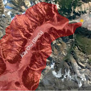
Region: Kluane
Traditional Territory: KFN, WRFN
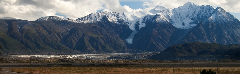
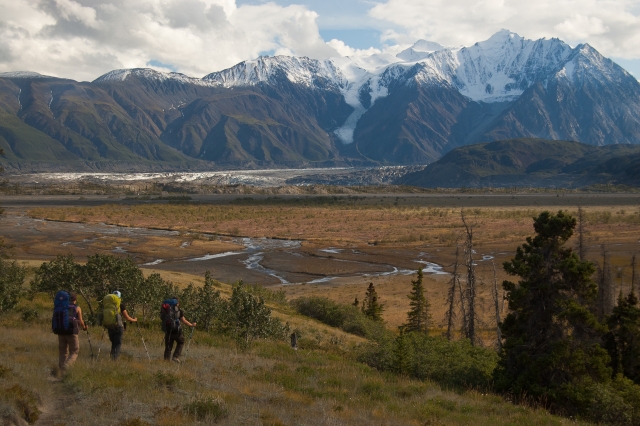
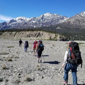
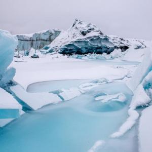
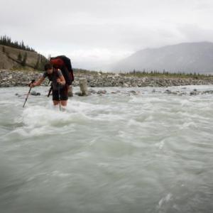
This trail follows along the west side of the Slim's River and ends up at a campsite about 2 kms from the toe of the Kaskawulsh Glacier. You are hiking into the heart of Kluane, so the mountains around you never cease to impress. Plan on camping at least 2 nights if you want to get a better view of the glacier. The trail along the river is long but relatively flat with a few damp sections and a couple of creek crossings.
CURRENT WARNING: Expect and be prepared for extreme dust conditions. Significant dust storms occur in this area, reducing visibility and affecting local air quality. Visitors should bring eye protection and a face covering, such as an N95 mask, to protect their eyes, mouth and nose during dust exposure. When possible, move camp outside the affected area. Call the Kluane National Park Visitor Centre to check on conditions before you go: 1-867-634-5134.
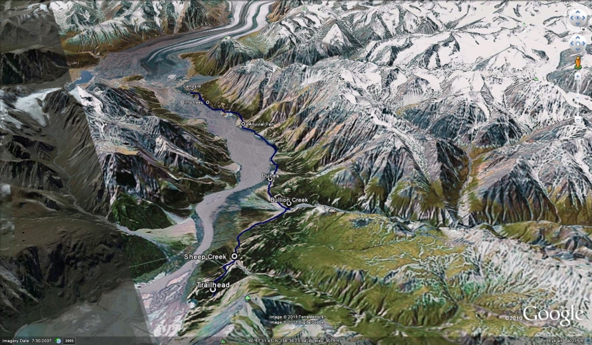
From Haines Junction, continue on the Alaska Highway north for about 70 km until you cross a bridge and see the Thachal Dhal (Sheep Mountain) Visitor Center. Immediately after the visitor center, make a left onto Sheep Creek Road. Follow this gravel road for about 2.5 km until you reach the parking lot and trailhead.
Note: Parks Canada requires registration for backcountry trips in the park.
The Slim's River West trail takes two days to complete; one day in, and one day out. However, it's worth staying a few extra nights at the backcountry campground, so you can explore the area, including Observation Mountain.
The trail passes through a gate and follows an old road which is wide and easy to follow. After 2 km you will come to your first creek crossing, Sheep Creek. Try crossing towards your right (upstream), near the cliffs. You may even find a log across the creek and may not even need to take your boots off. Otherwise, prepare for the creek crossing.
Continue following the old road past the Bullion Plateau information plaque. A boardwalk will then lead you across a marshy area. Unfortunately, the boardwalk stops quite short of the end of the marsh, so you will get your boots wet regardless. The next landmark is Bullion Creek at about the 6 km mark. Bullion Creek is a little larger than Sheep Creek and can be crossed towards your right (upstream), where the remains of cemented logs posts can be seen on the other side of the creek. During really high water levels, sometimes you have to go downstream to where the creek is more braided to safely cross. These creek crossings can be very dangerous and impassable during high water. During your registration, make sure to ask Parks Canada staff about current conditions.
After Bullion Creek, the trail disappears for a few hundred meters, but if you stay roughly in the center of the open area, you should come across the trail eventually. 2.3 km after Bullion Creek you will come across some sand dunes. Camping is prohibited before Bullion Creek and is not recommended at the sand dunes either (it is a special preservation area).
Your route for the next 7 km will depend on how wet the ground is. If the mud flats are fairly dry, then this is the easiest route to take. Otherwise, you may have to take detours in the trees towards the mountainside, but this can add up to 2 extra hours. Try the mud flats, and if if it's too wet to cross, turn around and detour.
Around KM 16 of the trail you will come to an alluvial fan (a wide creek delta of rocks and boulders). Follow the cairns (piles of rocks used as markers) to pick your way across the fan. Afterwards, you will encounter more marshy areas which you will again have to decide if you can walk through them or if you have to detour up into the trees. The detours always take longer, so if the marshes are not too wet, try and walk through them.
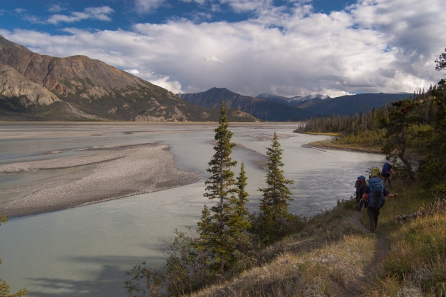
After 20 km you will leave the side of the river and follow a path into the trees. The path meanders up and down and will also climb steeply for a short while. The views will start to open up after a while and you can see the toe of the Kaskawulsh Glacier is getting much closer. It is 2.5 km through the trees to the campsite.
At the campsite, there is a fire pit with benches, an outhouse, and tenting areas. There is a nice clear stream near the campsite where you can get fresh water (not the little stream a couple meters from the fire pit, but a little further down the path). This area is well known for the amount of grizzly bears around, so keep your food and smelly items in a Parks Canada approved, bear-resistant food canister away from tent (these are required by Parks in the backcountry).
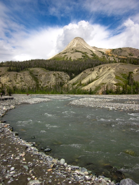
There are 2 creek crossings on this trail. Both creeks are cold, but neither is difficult.
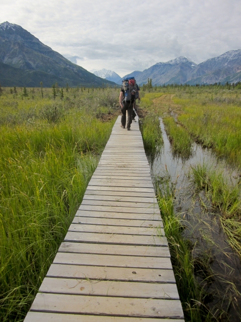
A boardwalk over the deepest part of the Coin Creek marshy section.

There are a few alluvial fans on the trail, and the route is marked with rock cairns.

Some sections are marshy or muddy and you have to decide whether or not you must detour around them.

The mud flats can either be hard as rock or wet enough to sink up to your knees.
When you enter the trees, you will be a little higher up and sometimes get a nice view down the valley.
Descending into camp with a closer view of the toe of the Kaskawulsh glacier and Mt Maxwell.
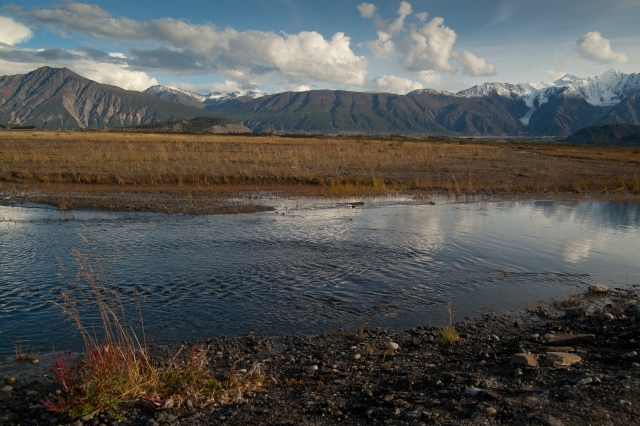
This clear stream near the campsite can be treated for drinking water.
HD October 2, 2024
Hiked this Sept 28-30, 2024. We lucked out with 3 full days of sunny clear blue skies. There was one creek crossing that was calf deep around 5km in but the rest we could hop across or use rocks/logs. Hiking poles were helpful on creek crossings and on Observation Mtn day. Trail is straightforward until the 12km marker. From there were able to cut across the marshy section to the first fan, and didn’t need to do the bypass. When you cross the fans, look for rock cairns and when in doubt stay low. No bear sightings but did see tracks. The creek was dried up near camp so had to walk almost 1 km from camp to find water. On the last morning, the creek was frozen so we had to melt/boil ice to use for breakfast. 99% of leaves had fallen off the trees by now but there was no snow yet except high on Observation Mtn. We could still hike higher than the plateau but wouldn’t have been able to do the ‘true summit’ at this time of year due to deep snow. Overall so beautiful and well worth it!!
Jay July 13, 2024
Did this last weekend (July 5-7th). We got stuck at Bullion Creek for 5+ hours on the way out because we got there around 5 p.m. Two members of our group were able to get across but by the time the rest attempted to cross (a matter in minutes) the water had risen to nearly waist-height and the current was extremely strong. Everyone finally got across around 10 p.m. when the water had dropped a little bit, but it was still a challenging crossing and colder than earlier. Hiking poles are absolutely necessary. Parts of the trail are swampy as expected. You can save a lot of time/distance by walking along the riverbed if the weather/conditions allow. Canada Creek was actually no issue and totally doable even in the late afternoon, though even colder than Bullion. The bugs were bad when the wind wasn't blowing, particularly the wasps and horse flies who seem to know to descend when you're crossing a creek and can't swat at them. I'm still nursing wounds a week later so would highly recommend a good bug spray.
Slim Shady July 6, 2024
We hiked this on the July long weekend.
The first creek crossing was easy but the second was quite high. If you find the right section cross, it stays at about knee level. At other areas however it can be closer to your waist. If you download the app Pocket Earth, it shows a good place to cross (or at least it did when we crossed). It's best to cross earlier in the day when the water is less high. The water was fast and strong.
There are boggy areas that can get really muddy and wet. It may be best to put your creek crossing shoes back on here or else you'll get soggy boots.
Fill up on water before you do the ascent at the end. You can get water from the campsite (from the eating area go towards the left) but it's a bit of a long walk and the water is very silty.
There were still a few camp sites left when we arrived. It was buggy out of the wind. We didn't do Observation Mountain because of Canada creek's high water levels (we heard it was well over the waist in the afternoon). We saw some bear & moose tracks mid-way through the hike, but no other signs of bears. Big sandstorm on the hike out.
Beautiful views the entire way and would highly recommend!
CM June 14, 2024
We hiked Slims West June 8 & 10th (Observation on June 9).
Long days but stunning views. We had very dry hot weather which, on one hand, helped us significantly when it came to the marshes and crossings further down the valley. On the other hand, we also had epic dust clouds due to the wind. I wore a buff the entire way out and was still blowing sand and silt out of my nose days later.
Sheep creek was easy to cross both in and out (coming in we crossed around 11am and coming out we crossed around 3:30pmish). Bouillon was the harder of the two proper crossings, on the hike coming out it was above the knee and running pretty fast. Not too bad though, and still ok compared to the creek crossings if you do Observation Mountain.
Further down the valley, due to the dryness of the river beds and marshes, we did not have to once detour into the trees. Full disclosure, we could see the path through the trees on the hillside and it does not look like a good time. If you can stay on the creek beds or the marshes it is worth it. We ended up walking the creek bed the whole way to the campsite, skipping the last path in the tree covered hills (as described in this Yukon hiking description). Walking on the creek bed the whole way added extra little creek crossings but none were high and they were also kind of refreshing and nice in the heat.
Lots of giant bear tracks, moose, deer, etc. Saw three other groups while we were in the valley but none of which were camped at the official campsite at the end of the valley with us. Official Campsite was very nice! Nice flat areas for tents and the trees block the dust/wind storms very well. Not to mention the view of Observation Mountain and Mt. Maxwell.
The stream for drinking water by the camp is very small and a bit hard to find but it was the clearest drinking water we found the whole trip. Most creeks had dirt/silt in it.
Saw many sheep, some goats, ground squirrels and only 1 bear that was on top of Observation Mountain. Overall, beautiful trip!

@behindthehikes September 6, 2022
Completed this hike on September 3.
There were still muddy and wet sections just passed the board walk in the beginning of the hike. It wasn't too bad but gaiters would help.
The first creek crossing was fairly easy - there were a couple of logs that you could walk on and it was pretty slow that you could probably find a few spots to jump on. Bullion creek was also not too challenging; there are plenty of spots where the water level was pretty low and not strong.
Had a bear sighting during lunch break by the sand dunes. Saw a bear about 2 km out in the middle of the river bed running towards the trees (must have been running 40km/hr). Such a neat experience to have witnessed it from afar.
You can pretty much walk on the river bed to get to the campsite faster, however, we opted to go through the trails in the forest where it's easy to follow and we don't miss the sign just before doing the last 2km ascent.
Make sure you fill up your water bottles by the boardwalk just before the 2km ascent as there weren't a lot of water sources near camp.
Overall, it was a great day for a hike.
Shailyn August 19, 2022
Finally hiked this bucket list hike of mine on August 13-15. Truly an all around stunning hike! For a flatter hike, I was surprised how exhausting it was, but my watch did show a substantially larger elevation gain then the Parks Canada or this Yukon Hiking website lists. We did not encounter any wildlife, but a group hiking the same day said they saw a grizzly. Tons of grizzly, moose, deer and dog (wolf or coyote) prints along the river. Bullion Creek was still quite high around 1pm on our way in, and knowing it would be much higher on the way out (around 7pm), and because of my creek accident and lost poles (as a result) the day before, we opted to stay low, walking along the river on the way out to cross where Bullion was braided. This proved to be such a great option as bullion was then about 20 ankle deep little crossings. After that though, we had to bushwhack back to the trail, which was kind of a terrifying 1.9km bushwhack in dense berry bushes and deadfall. I still know that was a better option than attempting a really high Bullion creek crossing. I do wonder if maybe there would have been a good option to keep along the river (instead of bushwhack back to the trail) and join closer to the trailhead (maybe at shepherds knoll). Anyways, this trail was 360 stunning views! Such a great hike and now I've been spending days getting all the fine glacier silt off all my gear.
Mike August 20, 2021
Hiked the Slim's August 17-19. Bullion definitely easier to traverse than last year's rainy season. Be warned if you opt to cross near the main path of the trek, water can be near your waist. Better to spend an extra 45 mins going downstream where the braids are. We opted to go around Canada creek up Observation Mountain near the braided parts directly straight from the campsite, however, on return, we noticed that the creek was passable higher up - though be warned that water can come higher than one's knees. Beautiful hike. Worth the effort. Having GPS is worth it as you do loose your way at times and find yourself needing to hike back to find the main path which is a less "wet" route. Lots and lots of bear signs - paw prints everywhere. We never ran into the beautiful creatures, but the other parties we ran into all stated they saw bears on their trek in.
k July 5, 2021
I hiked in on July 1st, and out on July 3rd, 2021. Keeping the GPS track handy was useful for certain sections of the trail that we less clearly marked. I hiked solo, so after 2 unsuccessful attempts (water was running too high, too strong and too fast) to cross Bullion Creek by myself at around 2:00pm, I opted to bushwack down to the river, where it was more braided. This added more or less an hour. On the hike out, I was able to slowly but safely cross it at around 6pm. If you are planning to cross on your own, I would recommend checking in with parks Canada, to try to figure out if you should plan for the detour or not.
Dee June 21, 2021
Hiked this June 19-20, 2021. The creeks were just above knee level (I am 5'2") though we did have to walk down to the braided section of Bullion Creek. We lost the trail going out towards Canada Creek several times and the hike took much longer than expected. We ended up camping on the alluvial fan around km 14 and did not make it out to Canada Creek in the end. We managed to pick up the proper trail route the entire way back to the trailhead and realized that despite having followed literal footsteps in the mud on the way in this was the wrong trail - it also explains why it took so long! Hiking back on the proper trail we made much better time. On the way in we mostly lost the trail at points between km 8 and km 11 and then again between km 12-15. We ran into two other groups who also mentioned having to backtrack and/or having lost the trail along the way.
There were some sections of trail underwater (around km 13) so expect wet feet. No other surprises. Lots of bear tracks but no sightings. I agree with others that making it to Canada Creek in one day would make for a super long day and if you can, it might be worth breaking up to enjoy the hiking and scenery a bit more. I am looking forward to doing this again and making it all the way out to Canada Creek!
Laura June 20, 2021
Back from this hike this weekend - Its very wet, prepare to have wet feet from beginning to end but all passable. Mud flats are solid. Bullion was fast moving and a little dodgey when crossed at 7pm on our way in. On our way out we arrived around 9pm and it was impassable. Hung out till 4am and made a smooth exit!
Mosquitos at the campsite are ravenous and will swarm you when setting up the tent - bring a bug/hood/jacket. Its a little better by down by the eating area.
Also - nearest water is at Canada Creek - which was about a mile past the campsite (might vary throughout the day though) - I'd recommend filling up your water before at one of the streams/creeks before you hit the campsite.
Jenna August 21, 2020
Hiked this in late July (before it was closed for two weeks) - one of my favourite hikes ever. The terrain on this stretch constantly changes, is mostly flat and the views are beautiful. However, it did take longer than we expected - took us 12 hours to hike the 22.5km into Canada Creek (with a number of breaks). We hiked out overnight, staying near Bullion Creek and doing the last 6km the following morning.
Everything I read suggested this was a 3 day hike in/out with Observation Mountain on day 2, but I highly recommend taking longer than that / with. more time than a day to hike in/out so that you can enjoy both the scenery and the Canada Creek campground, which is in a stunning location across from the toe of the glacier. We planned this as a 3 day trip with Observation, but ended up staying an extra night on the way out because the hiking days were very long (Observation was 15 hours on the hottest day of the summer - see post). The creeks, high this year, also added some uncertainty to our time-frame, and we were very glad we had a fourth day as buffer. With Observation, I would happily do this again as a 5 day hike to enjoy Canada Creek, have some recovery time from long hiking days, and feel less rushed, while having the buffer time to accommodate any high creeks.
Gaitors and creek crossing shoes were a must, as were hiking poles - grateful for that advice here. Bullion Creek is fast this summer and we ended up hiking down it quite a ways on the way out, then bushwhacking our way back up to the trail. Took a long time - but at least the creek crossing was easy. Beware that the creek water at Bullion and Canada Creek is VERY cold - neoprene socks would have been a help for my sensitive toes.
We saw tons of fresh bear prints and scat, but avoided seeing any bears - we made LOTS of noise though and I'm sure that's why. We saw only two other hikers and four people at the campground in 4 days, so this is remote - be prepared. Having a SPOT was helpful, as we were told that hitting the SOS prompts notification to Parks Canada, who would then send a rescue mission (likely helicopter) - perks of hiking in a national park.
Jackie July 14, 2020
Hiked this from July 10-12. The trail was relatively easy to follow, and in places where it petered out, there were stone cairns or flagging tape to follow. Creeks were good on the way in, but had some challenges with Bullion on the way out — water was fast and deep in a lot of places in the early afternoon, and required a few tests before we found spots we could safely cross.
Would 100% recommend hiking poles and water shoes are a must. There's a completely useless boardwalk a few km in that starts and ends in the middle of a marsh, with at least two more marshes on the way in, and a bunch of smaller creek crossings en route to the glacier.
The trail was pretty dry other than the two marshy bits, even with the bursts of rain. Basically flat until the last bit to the campsite, which felt absolutely brutal after 20km+, but which we zipped down on the way out.
If you're comfortable and the water's low enough, walking along the riverbed/flats will save a lot of time/distance vs following the trail (we shaved maybe an hour/4 km off on the way out vs the way in, could have cut even more but group felt more comfortable sticking closer to the trail).
We decided not to do Observation Mountain due to cloud cover, and did a comparatively chill hike out to the glacier instead. I would highly recommend taking at least four days if you want to to Observation, it would be kind of brutal to do it the day after hiking in, and heading to the glacier is a great experience with at least two small lakes you can hop into along the way and a cool landscape to take in.
I would highly recommend walking up the tallest hill by the campsite, the view is incredible.
There is no longer a firepit at the campsite.
We had three bear encounters, although two may have been the same bear. First was at Sheep Creek, mama with two cubs — mama acknowledged us after we made noise but the family just continued on its way. Second/third were at the campsite, with a grizzly way off into the distance — the first time, it started walking towards camp but turned away after we made noise, and the other time, it was just wandering around far off.
M+D June 27, 2019
Hiked this Jun 21 weekend. I am 5'6 and Boullion creek was about mid thigh (splashing right up to the crotch) on the way in and on the way out, after a rainstorm on Saturday evening it was up to my waist and splashing up above my belly button with a strong current. It was challenging to keep a solid footing even with poles. Creek crossing shoes (I wore a light pair of runners with wool socks) and poles are highly recommended.
The trail was muddy/underwater just after the sand dunes and the creek crossing on the fan had us removing our hikers so we kept to the river flats most of the way back, which was fairly solid despite the rain overnight.
Saw 5 grizzlies on the way out, but had no issues with them.
Syama May 29, 2019
Beauty trail, lots of creeks running at the moment (we counted 38 creek crossings one way), but all were easily passable. Bullion creek about thigh high on a 5'2" person by early afternoon, and creek at km 14 was fast moving and deep. We moved downstream to the braided area to cross that one. Saw lots of signs of bear activity, and indeed saw a grizzly and black bear close to the Canada Creek campsite, both were weary of people and we filled out the bear observation form at Parks Canada. We did not attempt Observation Mtn as we warned by Parks Canada staff that there was too much snow. All in all, an amazing hike to a beautiful campsite!!
Jono Yiu February 2, 2019
Decided to give this a crack given the more challenging winter conditions and the minimal elevation gain here. We bought snowshoes along, which was definitely a good choice as most of the trail was snow covered. We followed the river plain for most of the way as it was frozen. Ended up being a long slog with the jut of land with the campsite not looking much closer for 20kms, maybe taking trail would have been a bit more interesting. Kuskawulsh Glacier was spectacular though! Spent two and a half days in total.
Sophie August 12, 2018
Did this trail this weekend - great flat hike with nice spots along the way to camp if you don't want to hike to the campground in one day. Sheep creek was easy to cross (ankle level), Bullion creek was deeper (thigh depth - see picture) but it's only over a few meters and it's possible to find shallower spots to cross if you walk down the creek towards the Slim River. Gear "must" for this hike are: creek crossing shoes (ideally better than Crocs!!), hiking poles (to stabilize yourself as you cross Bullion creek) and gaiters (for some muddy stretch along the way). Campground by the glacier has great views and fantastic landscape.
kyliestravel August 22, 2017
Did this trail over August long weekend (discovery day). Really busy weekend with 20+ people in an out. THe hike is pretty easy, with the low water levels, you can cut a lot of time by navigating a path over the flats - in, it took 5h40m and out 4h45m - Tough part is the weight with the bear cannisters. It's beautiful hike. Saw 1 juvenile grizzly on way in but otherwise with so many people, was a pretty uneventful wildlife spotting. The last bit of the trail is a killer once you have been hiking for a few hours with a heavy backpack!
Yukon Hiking July 5, 2017
This trail is currently CLOSED (as of June 28th, 2017). Check the Parks Canada website (http://www.pc.gc.ca/apps/scond/Rec_Rep_e.asp?opark=100252), social media accounts, or call 867-634-7250 for more information.
Jo June 9, 2017
I hiked this trail on June 3rd 2017. Waited for the rain to stop and got a late afternoon start. Followed the Slim's West trail as described. Trail is easy to follow and the 2 creek crossing were straight forward. Creek near campground had little water so I hiked to Canada creek for better water. Woke up early next morning and went up to Observation sub-peak then walked out to the trailhead. My feet had taken a bit of a beating so I decided to hike out in my crocs. Since the water level was so low, I opted to hike straight towards Sheep mountain in the middle of the drainage: Slims Central. This does involve more fords but with crocs on and low water level, the allowed me to save a bit of distance and time and made for a nice direct return trip with the added cooling benefit of multiple river ford on a hot afternoon.
Heidi Stiles August 30, 2016
***continued***
One thing we realized was probably missing from our packs were tensor bandages as we realized it might be really easy to roll an ankle especially in the alluvial fan areas. We also realized that just because it looks like water on the map, doesn’t mean you’ll be able to fill your water bottles from it and to fill them when we could. We used coffee filters and a LifeStraw for our water supply and filled up both at Bullion Creek as well as one unnamed water flow along the way again and then also with some very clear (no silt) water at Canada Creek area.
Heidi Stiles August 30, 2016
We did our first back-country camping with this hike so we planned to do out one day to the Canada Creek roughed-in campground and then return the next day. We did have a contingency plan that on our return, if the creek levels should be too high, we had enough meals and a plan to stay at Bullion Creek if we couldn't make it. We left the trailhead shortly before 11am arriving at Bullion some time before 1pm. We had no problems crossing at this time, we removed our pants and crossed with water shoes and used the tripod system with the second person (myself, the smaller traveler) behind the larger/stronger crosser. We had our dog with us also who is not really a swimmer so we put him on a harness and a rope in case he decided not to follow, then we could 'encourage' him across. We made it with no problem on our way through. We left our water shoes on a post to retrieve them on our return. It took us 7 hours to complete the 22.5 km hike out to Canada Creek/designated camping area. We are fairly experienced hikers but not with large packs but that meant we averaged around 3kms/hr which we thought was not bad for our first time. There were no further creek crossings that posed a problem on day 1 however, it is of note that you will cross several marshy/quite wet areas that cannot be avoided. We'd recommend waterproof boots and gaiters especially in cooler season - we were fine since we had two quite warm days. On our travels out, we followed the trail to its design, following along each alluvial fan and letting the cairns guide us through the open areas and following the trail up into the wooded areas which made for quite a bit of extra exertion. On our return trip we would cut out somewhere around km 20 and cut down to the Slim's River area (now mostly dry riverbed) and didn't rejoin the trail again until km 12 or so. Keep in mind to always watch where the pooled water remains so that you don't end up very far from the shore and unable to reconnect. Some benefits to this return hike are that the effort exerted is not great and also, there is great visibility for bears. When we were in the woods, we made a lot of noise since there were many blind corners and it would have been easy for a bear to surprise us. Some disadvantages were that it was quite windy and there was sand blowing towards us, (thank goodness the wind was from our backs), you are in full sunlight and also, there is quick mud here and so the ground that you step on is not always solid and it can be unnerving. All in all, we appreciated the easier hike on the way back. When we arrived back at Bullion Creek around 4pm on Day 2, the creek looked much faster and seemed deeper. My partner decided he’d go across with his pack and the dog and leave both on the other side and come back for me. Well the water was just under his hip bones when he went across and he decided to give up on the dog since he lost his balance and fell to all fours. Thankfully not much got wet and he was fine but then he and parts of our tent were on the other side so he had to make the trek back again or we’d be apart and both without proper shelter. He made it a little more succesfully but we decided that if it was that high on him, it would be even further up on me and I’d likely wash down the creek. We decided to make camp for the night and eventually another couple joined us also. We woke up around 6:30 in the morning and started crossing around 7:30am and the levels were much lower and much safer and all four people and one dog made it across with no problems. (we all waited to cross together for extra safety) There is a little fire pit area against a rock wall if you walk up the creek against the direction of the current in case you are cold/get gear wet but there are not a lot of places for wood. We found enough wood to keep us warm and left our bear bins in that area overnight. All in all, we loved the hike, we’re glad we brought extra food and would strongly recommend it to others.
Ashley Russell August 11, 2016
We attempted this trail at the end of July. There had been quite a lot of rain in the days before we got there. Parks Canada staff warned us that Bullion Creek was high, and that many people had turned backed. They even had to initiate search and rescue the previous day because one group had not returned when expected. Luckily they were quickly located; they had been stuck on the other side of Bullion Creek, unable to cross due to high water levels. We decided we'd go take a look and figure out what to do when we got there. Parks staff suggested that water levels would be lowest between 2am and 7am, so we began our hike around 6am, as it is not too far to Bullion Creek from the trailhead. Sheep creek was easy to cross, so we were feeling optimistic. When we arrived at Bullion, a couple were just putting their pants back on having successfully made it across. This also gave us hope that we could make it! We spent some time walking up and down, looking for a good spot. It all looked very deep, and the current strong and fast. We figured that the other couple had made it, so we started crossing close to where they had. After side-stepping just a few feet across, the water was above our knees (we're both tall), and the current extremely strong and fast. It looked to be deeper on the far side. I felt unable to keep both feet firmly on the creek bed as I fought the current, so we retreated back to where we had started. We then walked about 1km down stream (which included some decent bush-wacking in a Grizzly-bear buffet of berry bushes!), to see if we could find some braiding and shallower waters. We thought it looked better so made another attempt, but it still didn't feel right. It was a hard and disappointing decision, but we didn't think it was safe to continue, so we headed back. Upon returning to the parks office we were told that a girl had nearly drowned trying to cross a creek on another trail the day before. We were also told that a man died trying to cross Canada Creek on the Slim's River just last year. I'm not trying to scare people, but just know your strengths and limitations. We are not very experienced with creek crossings, so we felt it was the right thing to stop when we did (as much as we didn't want to!). Just be aware that the water levels can be high at Bullion Creek if there has been rain. A parks staff member also mentioned that one man had been able to find a better way across by continuing to bushwhack another km down stream from where we had stopped. So it might be worth trying a big detour downstream if water levels are high.
Sharon Moore March 2, 2016
Thinking of skiing the slims river west trail over Easter...anyone have any trail reports or know if there is a trail broken?
Thanks :)
