Total Distance: 10 km
Return Time: 6 hours
Elevation Gain: 1163 m
Difficulty: Difficult
Region: Kluane
Traditional Territory: KFN, WRFN
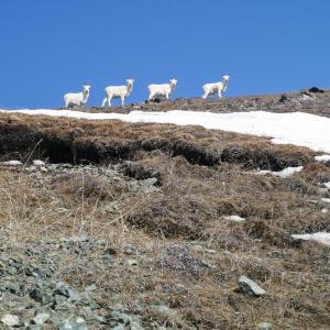
This trail is much steeper and more strenuous than the Sheep Creek Trail, but you get a view overlooking Kluane Lake and the surrounding mountains the entire time. You don't get a view down the Slims River as you do on the Sheep Creek Trail. Note PARKS CANADA asks hikers to avoid this area during the lambing season from May 1 to June 15. Outside of this period you still need to practice safe viewing from a distance of 50 m.
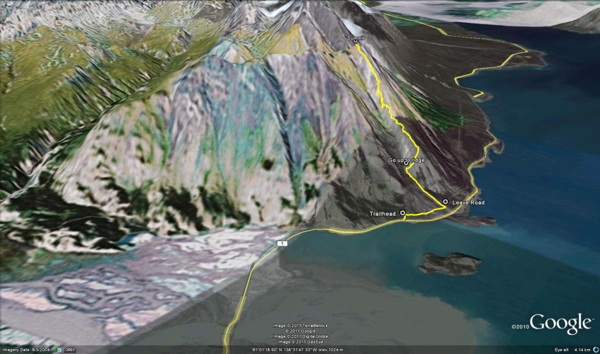
From Haines Junction, continue on the Alaska Highway north for about 70 km until you cross a bridge and see the Thachal Dhal (Sheep Mountain) Visitor Center. About 1.5 km after the visitor center is a parking lot on the left (west) side of the highway for Soldier's Summit. Park here, the trailhead is to the right.
There is another parking area and trailhead further down the highway with a slightly easier approach avoiding the scree ridge described below (about 3 km from the visitor center). The trail starts right across the highway and follows a steep grassy ridge.
Walk up the trail for Soldier's Summit and turn right at the park bench. You will be walking along the old World War II Alaska Highway (more of a rocky, dirt path).
After about 600 m, there is a foot trail on your left that leads up a hill and into the trees (the trail is not marked, but is well worn, so just watch for it). Follow this trail for about 700 m until it peters out and you are below a scree ridge. You want to be on top of the ridge to your right, so switchback up the steep scree until you reach the top of the ridge.
Once you are on the ridge, you can follow it up to the summit. Looking up, you will be on the right-most ridge - the one with the rocky outcrops near the top. It is easiest to stay on the left side of the ridge. Sheep and grizzlies are often seen along these ridges, so keep an eye out for them. Try not disturbing any wildlife - if they are in your path, circle around them or wait for them to leave the area if you want to continue. Note, dogs must be on a leash in the park.
At the summit, you get a 360 degree view of the surrounding area. You can turn back down the ridge and follow the same way down.
LOOP OPTION
It is possible to connect the Thechàl Dhâl Trail with the Sheep Creek Trail via the Thechàl Dhâl ridge. There is a fainter trail that connects the two hikes most of the way. It is best to have two vehicles and park one at the Sheep Creek trailhead. We recommend to climb up the Thechàl Dhâl side and descend down the Sheep Creek Trail, as it is easier on the knees going down this side.
Expect 14.4 km, 1,258 m ascent and about 7 hours for the total loop. There will likely be many options to view sheep along the way. Be sure to practice safe viewing from a distance of at least 50 m and avoid disturbing them as you travel. Avoid this area during the lambing season, May 1st to June 15th.
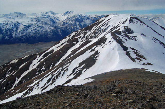
The trail is on the ridge to the right of the snow.
The first part of the trail follows the old WWII Alaska Highway.
This is where the trail leaves the old highway and follows a path up a hill and into the trees.
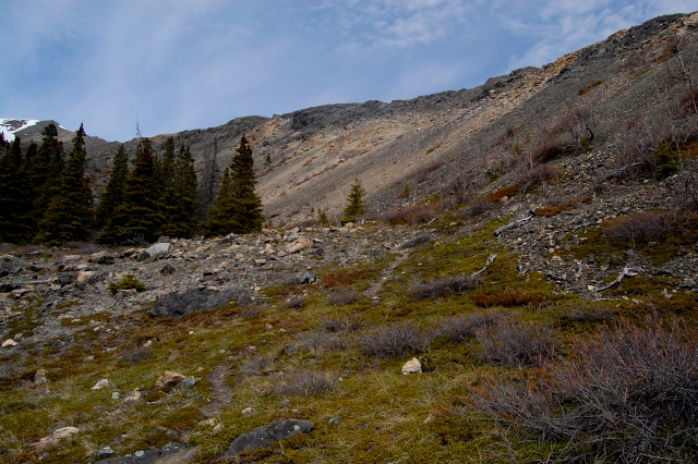
At this point the trail peters out and you climb up the steep scree on the right.
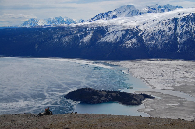
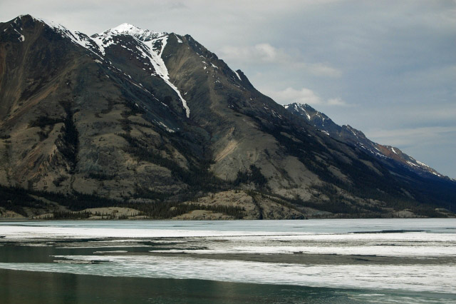
Taking a break on top of the ridge with Kluane Lake below.
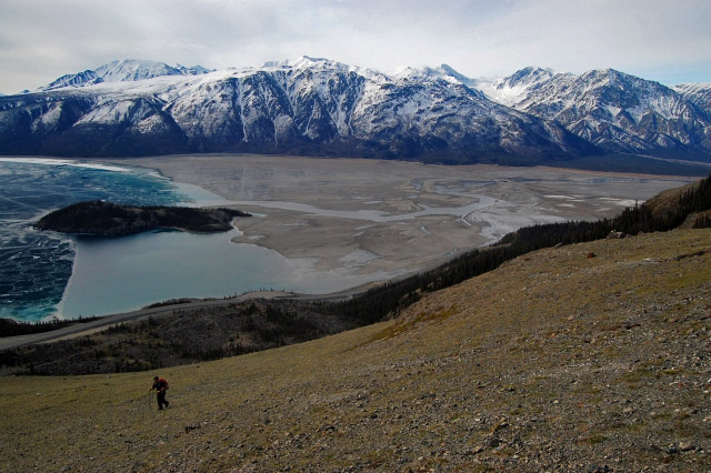
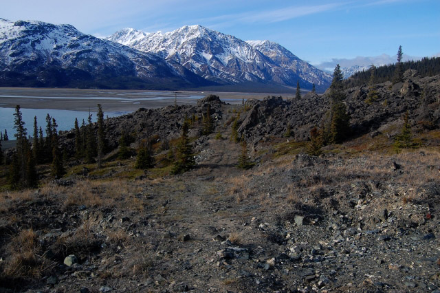
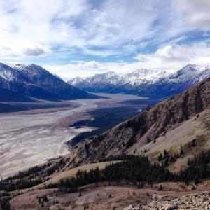
Hiking up the open ridge with views of Kluane Lake and the Slims River delta.

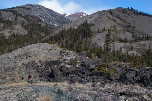
Looking up the rocky section of the ridge.
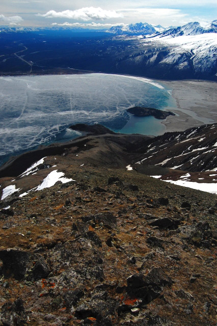
Looking down the ridge from the summit.
This is the southwest ridge you would walk if you wanted to do a circle loop to Sheep Creek.

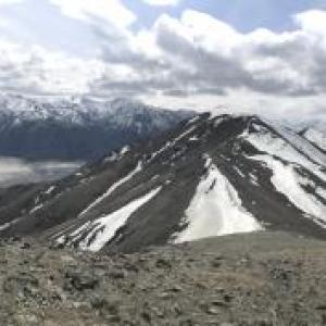
The view from the summit towards Sheep Creek.
Hannah July 2, 2024
Did this hike on June 22. Loose scree on the way up Sheep Mountain and steep but going up was fine (down might be a bit sketchy). We connected with Sheep Creek trail by following the ridge line. Though it is not a marked trail it is very easy to see where you need to go as it is the alpine and you can see the entire ridge. Gorgeous hike but, if you're going to pick one hike rather than connecting, I would pick Sheep Creek over Sheep Mountain. More varying views and views into big valleys rather than just Kluane lake. There was no snow that you had to travel over- just the occasional patch. Lots of sheep and many lambs.
J. Mclean May 28, 2019
Beautiful unobstructed views the entire way up. Hiked on May 17 (recommended by park workers). Had to take some longer detours to give the sheep ample room. This did cause us to lose the trail but at that point we just figured out a way up. Definitely some difficult portions but worth the outstanding views. Tough on the body but would do again-very rewarding. Good hiking shoes are a must as there are some treacherous portions.
Swim Upstream December 26, 2017
If anyone is going to split up on this trail with part of the group going up over Sheep Mountain and connecting with the other part of the group on the back side from Sheep Creek, make sure to take radios to be able to communicate back and forth. This was our plan, but we found out we forgot the radios. The trail took us longer to do than recommended here. Finding the connecting point off Sheep Creek was a bit of a challenge, and we used air horns to signal back and forth until we were able to get together. Going over the top on Sheep Mountain really requires topographical skills. We have a great memory there, but it was a bit iffy at points. And yes there's high grizzly activity off of Sheep Creek Trail. I would definitely recommend this trail though.
Yukon Hiking July 5, 2017
The Parks Canada Trail closures refer to to the
The Ä’äy Chù (Slims River) East and West Trails (not Sheep Mountain) as of June 28th. For more information call the Parks Canada Office: call 867-634-7250.
Common Sense Hiker July 5, 2017
A reminder to recent hikers that this trail has been CLOSED due to bear activity( whether you see them or not)and hikers should respect this as the bears are becoming habituated to humans.
Please don't be one of 'those people' who disobey this and then when a bear approaches someone it ends up getting killed because it's now habituated and poses a threat.
Check out Parks Canada for updates here:
http://www.pc.gc.ca/apps/scond/Cond_E.asp?oID=27810&oPark=100252
Toby July 3, 2017
Just did it on Friday, 30th June, at 5 pm. 3,5 hours up, really exhausting. used this GPS-track, which is pretty good. start at the boat launch or soldiers summit parking, take enough water, hiking poles are helpful, good hiking shoes mandatory. the view is incredible up there.
we saw many sheep, no bears were around.
have fun!
Lolo July 15, 2016
going this weekend thanks for the info
Malcolm May 8, 2016
Hiked this "trail" yesterday (April 7, 2016).
Lots of sheep, no signs of bears. No snow other than a few patches at the summit. Breathtaking views of the Kluane ranges and Kluane Lake.
Took about 4.5 hours including a lunch break at the top.
Great hike! I would advise good hiking boots as you will be mostly following game trails or making your own trail along very loose rocks on very steep inclines. Difficult but well worth it.
Happy hiking!
Voyageur April 5, 2016
We hiked this mountain on Sunday, April 3/16 under a blue sky. All the snow is gone except for the last 20m at the summit and on the north facing slopes. The trail is in god condition and there are only a few spots where scrambling is required. Loose gravel sometimes requires good hiking boots, hiking poles might also good to bring for those that are used to them. Make sure to take enough water since there is none on the trail. After the ascend from the parking lot we were welcomed by 5 sheep sitting at the summit and the breathtaking views to the Kluane Park Mountains and the lake were rewarding. A perfect time of year for this nice day hike.
Erin August 12, 2015
Climbed Tachal Dal aka Sheep Mountain Aug. 11/15 After following the trail described here,we found a friendlier trail down. If you enjoy scrambling on scree slopes and doing some free climbing, then this trail is ok for you. However, if you don't I recommend parking at the boat launch about 3km from the visitor centre. The trail starts right across the highway and there is no scree slope or "cliff hanging" required. This trail follows the steep grassy ridge on the south side of the poplar grove. You can spot the trail from the parking lot. The trail is steep but the views are worth it.
Jan Triska July 27, 2015
Hiked up on a warm and windy day last week.
The trail seems to present a couple of different options once about halfway up - I ended up on a ridge that I am sure was a bit harder than the 'normal' hike up. Other than this little detour, an enjoyable day. The views are stunning throughout - the Kluane Lake adds a whole dimension to the scenery here, a bit different from summit oriented hikes where we only see landforms but not large bodies of water.
About 5 hrs total, ascent and descent. Saw a few sheep at quite a distance, and some dug-up meadows that seemed to be the work of a bear.
Marko Marjanovic May 7, 2014
We hiked up the Sheep Mountain trail on the weekend. The trail was completely snow free. It was hot and sunny, about 15°C.
We saw close to 40 sheep on the mountain. We decided to hike up the depression to the left of the ridge because we wanted to avoid all the sheep above us that were on the ridge. On the way down, there were sheep everywhere and we couldn't avoid them.
It took us about 5.5 hours return, and we spent nearly an hour on the summit in the sunshine.