Total Distance: 21 km
Return Time: 8 hours
Elevation Gain: 167 m
Difficulty: Moderate
Region: Haines Pass
Traditional Territory: CAFN
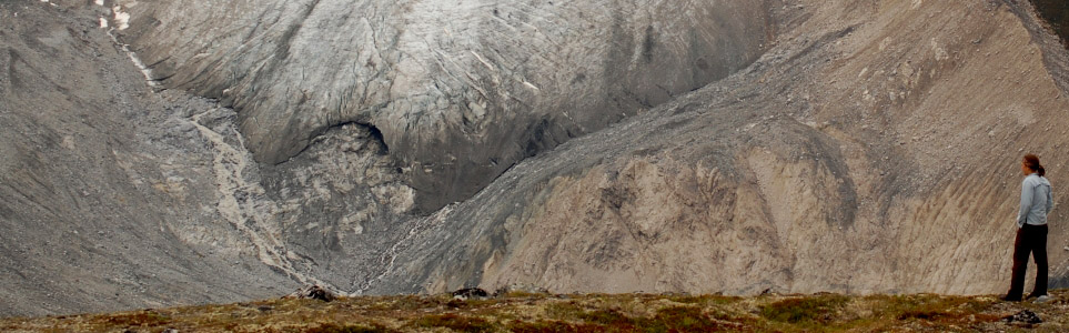
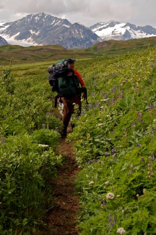
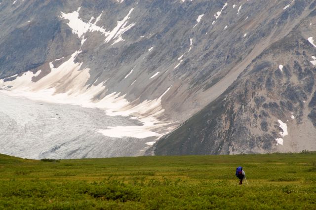
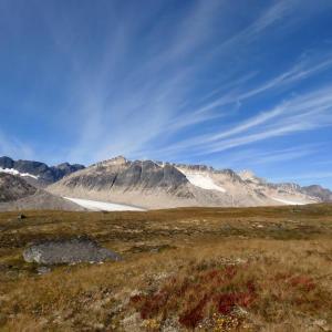
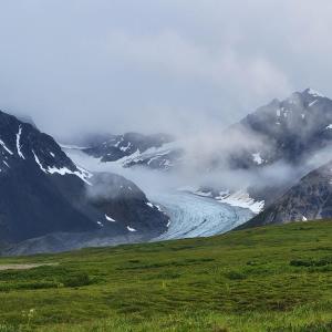
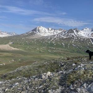
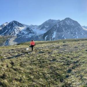
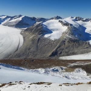
This hike is in Tatshenshini-Alsek Provincial Park in BC. The trailhead starts in the subalpine, so the trail is completely unobstructed by trees. The trail can be done as a day-hike, but is also a popular overnight hike. The view of Samuel Glacier is amazing, and its many snouts can be seen from the end of the trail.
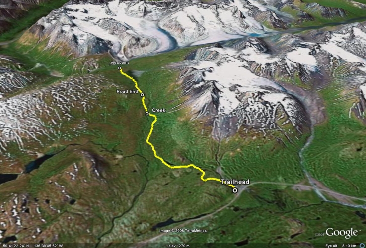
From Haines Junction, turn south onto the Haines Road (Highway 3). Drive for about 140 km to a large pullout on the right (west) side of the road. This pullout is in the subalpine just before the main Haines Pass summit. The pullout has an outhouse at the far end and ample parking room.
The trailhead follows an obvious old mining road from the parking lot. The elevation gain is relatively small, making for an easier hike. Follow the road through the sub-alpine as it winds its way alongside Nadahini Mountain. Keep your eyes out for grizzlies and make frequent noise, as it wouldn't be a surprise to see one in the valley or on the mountainsides.
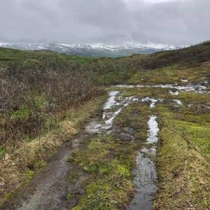
There are numerous creek-crossings which are small for the most part. There is a more substantial creek crossing around KM 6 of the trail and another around KM 10, where you may need to switch to creek crossing shoes.
After 7 km on the road, it ends and as of 2023 there is a newly built trail (thanks to BC Parks) that begins and takes you to the viewpoint at the end with the glaciers. There is an additional creek crossing for this next section.
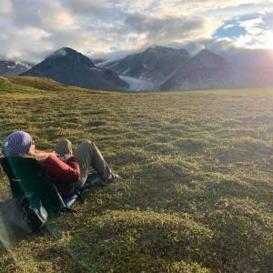
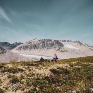
From the end of the trail you can camp, turn around, or explore further enjoying the glacier view. There is a valley separating the viewpoints from the glacier. To reach the glacier, you would have to continue hiking to the right (northwest) for some kilometers. Although Samuel Glacier isn't overly crevassed, it would not be safe to walk on or get too close, unless you have the proper gear and glacier travel experience.
Looking towards the Alsek Ranges from the trail.
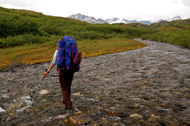
The largest of the creek crossings.
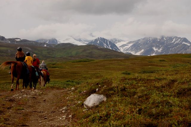
The trail is shared by mountain bikers, horseback riders and hikers.
Hiking through the boggy area near the end of the trail.
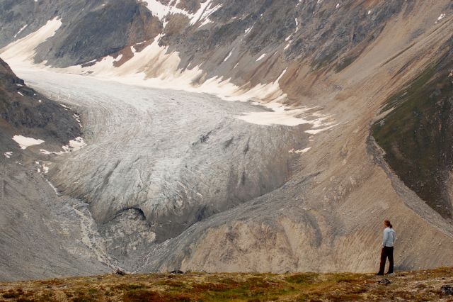
One of the viewpoints of Samuel Glacier.
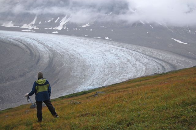
Another viewpoint of Samuel Glacier.
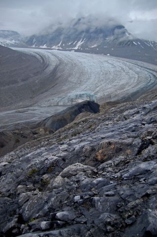
One of the awesome snouts of Samuel Glacier.
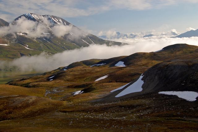
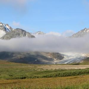
Looking back towards the trailhead, filled with low clouds.
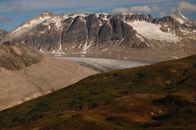
Base camp with a glacial view.
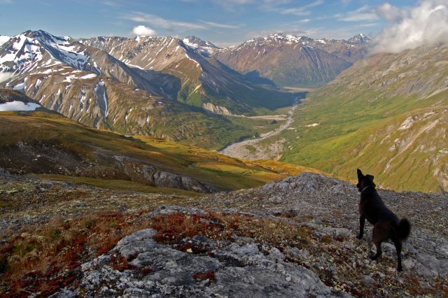
Looking down the O'Connor River valley.
Ree October 4, 2025
Hiked/biked this trail today. The ground was frozen when I set out (around 11 am) and wet and muddy upon my return in the afternoon. The trail and valley are still snow-free and the creeks were at most ankle-deep, love fall hiking! I encountered two other groups on the trail. Took me around 4.5 hours return (with a mixture of walking and biking). A gorgeous day with some low clouds moving through the valley and nonetheless great views.
No bear encounters though I did see some VERY recent tracks which briefly crossed the trail about 1.5 km in.
Jessica C September 8, 2025
Beautiful and well marked trail. Stunning scenery and easy hike. We started the hike at 1pm and had to remove our shoes to do the creek crossing and the silty river basin crossing. The overnight camping at the viewpoint was amazing and we woke up 'in the clouds'! The fog burnt off quickly and we didn't have to remove our shoes at the return of the silty river basin crossing as the water flow had slowed significantly overnight. We saw the infamous local grizzly feasting in a meadow below us about 1/2 mile away. He stopped and was watching us and we kept moving. He seemed happy in his patch and didn't move towards us. This was about 45 mins from the trailhead. Overall, a wonderful trip!

Karen September 1, 2025
Hi, I lost my phone somewhere on the trail on August 31, 2025. It's an iPhone in a faded pink case. If the phone is plugged in it will indicate that it's been lost. Please call 604-354-3875 if found. The phone should be somewhere on or along the fringe of the trail. Thank you.
Trail comments: Beautiful day when we ran in and also a long weekend. We counted 42 people on the way out (most were hiking back to the trailhead). The trail is great and well marked (thank you BC Parks). Bring creek crossing shoes if you don't want to get your feet wet. There was a group on bikes but I believe they stashed their bikes at some point when the trail became more technical. No photo to share because I don't have my phone photos....
Chris Kenny August 18, 2025
Hiked last week. Very wet. My favourite Yukon one night camping trip. Mountains were stunning and the trail is marked well.
Saeed July 29, 2025
Clear day on July 26, 2025. There was a grizzly report on the trailhead from early july and we saw a few spots on the trail with some fresh grizzly poop but luckily we didn't encounter any bear. There is actually 2 river crossing for which we went bare foot as the water was just a bit up to the ankle so it was fun. The views throughout the hike are stunning, this hike is so remote that you won't see a lot of hikers, even on a weekend and it makes it even more adventurous. We also crossed the last view point to get closer to the glacier but had to head back before it was too late. Overall we hiked 24 km and it took us almost 8 hrs including at least 1 hour of break/lunch.

Jess July 7, 2025
Great rainy hike July 5/6! Improvements to the trail since 2023 are great, making the hike even more straight-forward.
It's no surprise that there have been notes of bear issues around the trail-head. The garbage bins at the trail-head were overstuffed with garbage and unlatched. Some garbage was on the ground, and lots of food waste was inside waiting to attract wildlife. I was able to press the garbage in just enough to close them. On the way out, the situation had not improved and the bins had not been cleared. Notified BC Parks about this.
Attractants are what is leading to the issues with bears around the beginning of the trail and could lead to someone getting hurt or wildlife being killed unnecessarily.
Sophie July 4, 2025
We went on this trail June 27, 2025 and shortly before the creek, there was an avanlache that block the way. The rest of the trail (pass the creek) looked snow in. Have fun.

Elise August 28, 2024
Some friends were hiking yesterday (August 27, 2024) and at approximately 20 minutes walk from the trailhead, they ran into what sounds like a juvenile grizzly. It followed them, approached them, stood up and charged them. They deployed the bear spray but they found the bear to be very aggressive and had they not be back near their car, that it may have continued to charge them. This is second hand information but I thought it would be a good idea to warn people.
Jonny August 28, 2024
Aug 27, 2024. Had an Aggressive grizzly encounter around 1.5km into trail at 430pm. Bear kept following us and got on two feet. Eventually we had to spray it as it was less than 10 feet at that point. Bc parks was informed.

Anna July 16, 2024
Three creek crossings about mid calf/high calf high as of last weekend. Two small snowy patches to cross, otherwise the trails are pretty good. No bear paws nor scat on the trails.
Collyn July 2, 2024
The creek crossing is about knee height. Had to carry a couple of our dogs over. Currently lots of running streams at the top. We filled up at the last creek crossing and ended dumping it out as less silty water up top. Still some snowy patches. This may change later in the season. Great hike with amazing views!

Fran June 19, 2024
Curious about trail conditions for this weekend-June 21. Is it still snowy? I have been looking T Haines pass webcam but it does not show much beyond the road.
Ksenia Jack June 11, 2024
We did this hike with our dog June 8 and it was beautiful! You definitely still need snowshoes in early June but the scenery was stunning and well worth the trek. Lots of fresh flowing water along the way. We followed snowmachine tracks in and out to the glacier.
I do want to add a caution for those with dogs: we camped our RV in the gravel pit and our dog ran around that area. When we got back to town we had to take our dog to the vet because she wouldn’t eat or drink, had thick drool, was lethargic. I was worried about heat exhaustion/dehydration but the vet said our dog had gotten into something really caustic that damaged the inside of her mouth. The vet prescribed pain killers and a medical mouth wash that is usually given to cancer patients to help relieve the pain of mouth sores from radiation treatment. Please be careful if your dog is off leash in the gravel pit area at the start of this beautiful hike.

Shailyn August 28, 2023
Hiked this as an overnight hike August 26th and 27th. I had not been on this trail in a number of years and was pleasantly shocked at the amount of trail grooming and building that has occurred. There is now a very defined and easy trail that goes all the way past the km 6 creek to the right of the valley all the way to the hill above the glacier (multiple sign posts and all). It is quite nice to see, since it will help limit impact on the fragile plants. That being said, the trail now includes multiple new creek crossings, including one that is even bigger than the 6km creek (during the alluvial fan at km 10). This trail description is therefore out of date and should be updated. A note about camping near the glacier. The km 10 creek is incredibly muddy (like chocolate milk), but if you go just beyond it, there is another clear creek for water. This is the last available water for camping (and 1km away from where you would camp), so best to fill up there (and maybe bring an even bigger water holding container). The km 6 creek was just above the ankle, and the km10 creek was just below the knee. Due to the new trail it is now a great trail for biking and trail running. Despite hearing about a few bad bear encounters this past week, we luckily did not see any (but someone else we passed on the trail said they did). Always a good trail to make a ton of noise!
Kathy September 16, 2022
2022-09-11 Samuel Glacier (Stikine Region), Tatshenshini-Alsek Provincial Park, BC.
Beautiful Hike, spectacular views!! ~24KM & 525M total elevation
Llewelyn August 22, 2022
Hiked this route Aug 20-21. Amazing weather and spectacular views! The stars at night were mind blowing too, especially after several months of almost no stars at all:) No bear sightings and no signs of bear activity. Plenty of ground squirrels though!
The start of the trail is ~km 107. About 2 km prior there is another smaller parking lot with an outhouse and a small green shack. That's NOT the trail head, though we were told you can bushwack from there. The actual trail is an excellent condition right now. The crews have done lots of work, fresh gravel, culverts, rocks in muddy areas. Only a few small mud patches and many many small stream crossings, which were a lot of fun.
After the trail ends we picked our way along the left side of the valley (boggy at the bottom, but mostly can pick a path at this time of year) and eventually gained elevation for easier route. On the way back, we took the other side of the valley, many small ridges - lots of up and down. From there we saw a trail people were walking right through the middle of the valley bottom. To get to it, cross the creek on the right about 30 m past the cairn (it was pretty shallow, but may need to take boots off) and the trail will be visible a bit ahead. The trail looked to lead to the eastern corner of the triangular gravel fan on the glacier end of the hike, just before you decide if you want to camp on the left or the right side. Another creek crossing (also possibly with boots off) to climb the hill on the right.
Tom August 16, 2022
Hiked 26-27 July.
Trail building crew was hard at work; the trail is in excellent condition almost all the way until the end of the road.
Akriti August 7, 2022
My first camping and hiking experience ever! What a picturesque location. Make sure you have the proper rain gear because it was pouring. There is plenty of parking available, and there is also an outhouse at the beginning. This easy hike provides a mesmerising view of the mountains. Crossing the creeks was enjoyable. Two creeks had knee-deep water, whereas others had relatively less flow. No bears were spotted by us.
Strongly recommended.
George June 14, 2022
Route is almost undoable, lot of snow, mud aand water all around. Without gps nav no chance to hold on a trail.
Danette August 10, 2021
Hiked this and stayed the night this past weekend. Was pretty wet, we got rained on a lot, but super beautiful. Found a good camp spot no problem, and there's a water source right there. We saw no bears, and no signs of bear! One creek crossing required taking shoes off, but the rest were just stepping on rocks, no wet feet. Was an enjoyable hike, and a very beautiful area! Only took us 3 hours to hike out, and about 4 to hike in.
Kathryn July 12, 2021
Biked and hiked (day trip) into the valley July 10th. We thought there might be snow but it was free and clear. The route is pretty mucky from the first real shoes-off creek crossing to the end of the road but other than that, the trail was quite dry. No bears or bear signs. We kept left after the end of the trail and continued up and over to get a view of the other snouts. Worth the extra effort. We were in and out in 7 hours and covered 25kms. Enjoyable as always!
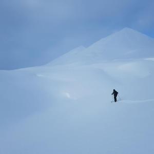
Matt A February 9, 2021
A cracking day out for a ski this last weekend in early February. The snowpack was insanely deep! The landscape is entirely unrecognisable when comparing to the summer. The snowpack was mainly hard. No recent travelling to be seen by anybody.
Almost made it to the end of the valley but fell short as we reached our turn around time.
All in all, a cracker!
JonD August 30, 2020
No bears aug 29 2020.
Karen F August 26, 2020
I hiked this trail with five people on August 22, 2020 and we loved it! So beautiful....one of the most stunning hikes I've ever done. We camped overnight and followed all bear-safe protocols by making lots of noise, storing our bear canisters with food, fuel and toiletries away from camp, and using the bathroom away from camp as well. We (luckily) had no issues at all and even though we saw lots of bear scat, we had no sightings. There were a few muddy sections and many tiny creek crossings but only one that required sandals. All in all this was a FANTASTIC hike - highly recommended!
Ingrid R July 19, 2020
I almost did part of this hike on August 1 2019. I had encounter with one of the grizzlies, which jumped on my tent. I screamed like a little girl and the bear moved away enough for me to get out of tent. I have been wondering about this bear (who I have named Samuel) for the last year and hoping it remains alive. Sounds like it is - thankfully.
I was camping on one side of the trail just up from the trail head alone, and a group from a camp was camped was on the other. The bear had gotten into their food, which was in a bear fence that was not working, before it came over to my tent. My food was in my car in the parking lot and I had a bear canister for my night out (also in the car). I set of a bear banger which did not phase the bear.
I did do part of the hike later that day and it was beautiful, but decided not to do the overnight alone (even with my bear canister). Please use proper bear food storage, be aware and keep this bear and others alive, and humans safe!
Maya P July 6, 2020
Amazing place! Went in for my first time for an overnight July 2-3. Trail was great! A bit wet towards the boggy area at the end but I assume it is always like that. I camped high to the left and there were tons of little benches to camp on with an incredible view, no where far from water!
On the way out I had to keep an eye on a young grizzly that didn’t appear to be phased at all by humans. Likely to be the same bear Leah S ran into below. There was an other grizzly sun bathing about 1/3 of the way up the mountain on the north side of the trail. No problems with it.
Definitely recommend bear spray, bangers and dogs in case of bear encounters.
Leah S July 5, 2020
We did this as an overnight July 2&3. It was absolutely beautiful and the weather was sunny and hot. We hiked about 25km total trying to avoid boggy areas and we jumped over 40+ small to large creek crossings. Waterproof boots are absolutely necessary.
We encountered a problem bear on our way out. Took almost an hour before we cleared it and it was a little too close for comfort at one point. It didn’t seem overly phased by all our noises and was too curious about us. I recommend bear bangers for sure.
Deb July 1, 2020
Just got back from a 3 day/2 night hike up in here. It's approximately 15 kms. from the parking lot to the valley edge where you can see the glacier with no obstructions making this a 30 km. round trip, not 21 as indicated. There's lots of water to drink and walk through so an extra pair of shoes and socks are recommended. Beautiful hike. Cold nights at maybe 1 or 2 degrees.
Brook Land-Murphy June 9, 2020
hi: we're planning on doing a hike basically adjacent to this trail in early July, and was quite concerned to read all of the posts from last summer. Does anyone have any intel about recent bear sightings there?
Daniel August 22, 2019
Interesting to read Aug 11th comment about the bear. We (four of us) were camped out which sounds like a similar location on July long weekend and had a grizzly bear wander into our camp. He did leave after we used the air horn. First thing we did when we saw the bear approach was to put our food away into bear resistant canisters. I hope this will serve as cautionary reminder for people to start using these (canisters or bear bags) when in bear country. Now this bear (which may cause further problems for others) may have to be destroyed etc...
Liz B August 11, 2019
Myself and 2 others hiked this on August 9th. All in all the hike took us 7 hours, that included a one hour lunch break at the glacier. The trail is well worn and very easy to walk on... a couple creek crossings, which we were able to rock hop across. The last few kms of the hike are choose your own path, again easy walking. There are a few wet areas along the way so good waterproof hiking boots are probably worth having. Our fitness trackers have us an elevation gain of 487m.
On our way to the glacier (at km7) we ran into a group of 6 that had camped overnight. They told us they had a bear hanging around their camp all night and morning. They were not able to scare the bear off and it apparently got into some of their food. We decided to continue walking, keeping a close eye out for the bear. We didn't end up seeing it so the bear must have moved on but since it got into the campers food there's a good chance it will keep hanging around that area. Definitely be bear aware!!
Marney July 8, 2019
Just a warning for those venturing out on this trail: there are a lot of flies and mosquitoes. Be prepared! Our walk on July 4/5 had way more than we were prepped for!
Shailyn June 19, 2019
Headed to Samuel Glacier for a trail run with a friend on June 16th. I had hiked this trail before and loved it, so we thought we would give running it a shot. It was quite muddy with numerous seasonal streams flowing (more than last time I went!) so running was a bit slow. We also decided to walk through the dense willows so avoid wildlife encounters at a fast speed. It was a nice (but wet) day out. Great trail for hiking, but harder for running (especially past the main creek). No signs of wildlife that day.
Karly May 28, 2019
We tried to hike Samuel Glacier on Thursday May 23rd, the trail was flooded with water and there was a ton of snow. We slowly started the walk but the conditions we're so poor that we couldn't see the trail and decided to turn around. We will be back in a month or so to see if it's clearer :).
Lynn Calvert October 5, 2018
August 2018 Started later in the day but didn't realize it was that far. Didn't do research and happened upon it. Decided to camp overnight and do it properly the next day. Spectacular. On a clear day to boot. One of the best hikes of our five week trip to the Yukon.
Stephan, Calgary AB July 3, 2018
Hike this trail on July 1st 2018. Highly recommend it. Great views into the valley and rewarded with amazing scenery in the end.
Trail in wicked condition, well beaten and only last 4km needs a bit of trail finding.
We did it in a day but wished we made it a 1 night trip so we had some more time to explore the glacier area with some side trips.
Recommend when arriving at the end going for another 2-3km further north to get some amazing views of the other glacier. Follow me on Instagram for photos or send me a DM @backpackerBeckr
Stephan, Calgary AB July 3, 2018
Hike this trail on July 1st 2018. Highly recommend it. Great views into the valley and rewarded with amazing scenery in the end.
Trail in wicked condition, well beaten and only last 4km needs a bit of trail finding.
We did it in a day but wished we made it a 1 night trip so we had some more time to explore the glacier area with some side trips.
Recommend when arriving at the end going for another 2-3km further north to get some amazing views of the other glacier.
Angela July 3, 2018
Hiked this on June 27. Trail was totally snow free and only a bit muddy in upper sections (it was sunny and it hadn't rained for some time - I could see this being muddy in periods of rain). Creek crossings were mostly easy, with only one requiring me to take boots off (and it's likely that someone more bold/long-legged could've kept them on!). Was glad to have worn pants to save my legs from the alder when dodging muddy sections and for the wind coming off the glacier. As described, the trail follows an old mining road so if it weren't for the incredible scenery, this could be a fairly dull hike. Only saw 3 other people on the trail that day.
We were tight on time this day, so we opted for the trail to the left in the meadow and turned back before we'd have liked to. Next time we'll opt for an overnight or ride our bikes in -- there is so much exploring to be done up there. Unreal area!!
Cor August 21, 2017
This trail is actually called the Chuck Creek Trail as noted on signage at trailhead. We day hiked in on August 16, to see three tongues of Samuel Glacier. Weather had cooled off, and surprisingly bugs were not a problem anymore (though for KB they had been -see below). Also, no signs of any bear activity at all, which surprised us. Only old diggings. They must have still been over with the salmon runs that were happening a bit later this year!
We followed the right side of the bog when the trail petered out. Found trail off and on, but not clear at all. View is wide open to make your way though, so just keep above the sinking and you'll be fine. Boots a must, gaiters even better!
When we continued veering right over the alpine meadow hills, more tongues of Samuel Glacier come into view. You could easily head downwards to get up close and personal with the middle glacier tongue, and have an endless choice of camping spots away from anyone. Note, the glacier you see after a couple hours hike in is not the biggest one! We stopped for lunch in front of the first one we saw, but glad we wandered right to get closer to the other tongues of the glacier. We even spotted some cool, yet small cave openings in the ground along the way. Probably a decent cave system under them ther hills!
KB August 14, 2017
Did this hike as an overnight the weekend of August 5- probably the hottest and most beautiful weekend of the summer! Thanks for Norman's comment,below, we were able to find the trail again by sticking to the right after the trail peters out- one small creek crossing and we found the trail again while also getting out of the boggy valley!
One thing to note- the bugs were horrific and some of us got pretty chewed up from deer flies and horse flies. Bring lots of strong bug spray and a bug head net if you've got one! I was fine with a long sleeve top and pants, but a stronger bug spray would have helped!
Nicole July 3, 2017
As of yesterday, the trail past the first major river crossing is quite muddy and snowy. I would suggest wearing waterproof hikers! Also, walking in the rocky valley bottom near the end of the hike is suggested..its dry and flat!
Marc July 2, 2017
I guess you can start seeing the glacier about 16KM into the hike. So it would be nice to at least get there even if the views are nicer once you get close. Other than that, you still have nice views of the mountains even if you don't make it all the way. So I would say yes it is still worth it, but it would be really worth it to get to the end!
Erica June 30, 2017
Hi, would this trail be worth it if one could only do a couple miles in? Thanks much!
Diane June 10, 2017
Hi we are coming from Winnipeg on June 30 to Whitehorse/Kluane and are looking for affordable guided hikes about 4 hours we are both fit (intermediate). Normally we hike alone but I a bit nervous about grizzlies, not having any experience on that front, so prefer to be with an experienced guide. Any suggestions? Thanks!
Manu June 9, 2017
Hi, we were in the Haines Pass area for the last few days and there still is a lot of snow left, way too much for a hike actually. It has already started to melt pretty fast since yesterday, depending on the weather conditions it should be all good in a couple weeks in my opinion. We spotted a black bear not too far from the start of the trail.
Selene June 6, 2017
Anyone tried to hike recently?
Jo October 11, 2016
Hiked to Samuel Glacier on Sun Oct. 9th. We stayed on the left side (South) of the meadows after the trail becomes indistinct to avoid the wetter sections but decided to cross to the other side and make it to a further viewpoint closer to Samuel glacier at GR012174. We then continued in a E direction to intersect with the ridge of the mountain right across Samuel Glacier. We worked the easiest line of ascent on the E side of the ridge up scree slopes and made it to the summit at GR021194. This is an incredible viewpoint and a worthy objective in the area. We came down the way we went up and followed different ribs back down the valley, this time staying on the left side (North) to meet up with the old road.
Kathryn August 28, 2016
We day hiked the trail on August 27th. The trail was in good shape, a little wet in some places but not bad. Kept our eyes open but luckily no bears for us. Saw some prints around kilometre 3 but they were days old. After the trail peters out, stick to the right and try to find the old vehicle tracks. Stay up higher and then come down onto the rock river bed. There are some rock markers but they are few and far between. Dry weather and a beautiful hike!
Jennifer August 14, 2016
Hiked to the glacier over Discovery Days. Encountered three separate bears and set off bear bangers at one point when they got too close to camp. Make sure you eat away from campsite and take a bear keg. Be extra bear aware since a lot of activity in this area.
Tatlow July 31, 2016
Terrific weekend hike with gaiters and boots...water shoes to cross creeks not required. Fine dry weather and photo is view we woke up to this morning from our base camp
Sophie July 11, 2016
We did an overnight camping trip at Samuel Glacier this weekend and had a blast! The trail was easy to follow and the creeks were not too bad to cross. The bigger creek at 6 km was pretty shallow, but definitely required to take our boots off (would recommend a good old pair of crocs for that matter so you can stay dry and still have some kind of firm footing). The trail was muddy in some parts so a pair of waterproof boots is a must.
We set camp around 8-9 km in the meadows on the right side of the creek. On Saturday night right after our meal, we saw two Grizzli bears approaching in our direction on the left side of the creek (about 200 meters from us). They stopped and watched us for a while but then walked away and did not look interested in us. We definitely recommend to follow good bear safety practice such as cooking and storing your food far from your cam, and using bear canisters. No other bear sight to report that weekend.
Cristina July 4, 2016
We hiked Samuel Glacier last weekend for the first time.
We didn't see any bear but it was pretty crowded because of the long weekend.
The trail was pretty muddy at some points and very wet, specially after the Km 7, where you have to start picking your own route.
We highly recommend a good pair of waterproof boots.
We tried to get down to the snouts of the glacier but we couldn't find a safe way to do it. Does anybody know the best way to get there?
KC June 29, 2016
Does anyone have an update on trail conditions? Bear sightings?
Many thanks!
Christel June 8, 2016
Has anyone hiked into Samuel glacier yet this season?
Just wondering whether it's still snowy/wet or whether it's nicely dried out with the warm spring we've had.
Thanks!
Emylie March 23, 2016
Hey folks,
Has anyone tried to hike it in the winter/spring?
LC September 11, 2015
Hey folks, beautiful hike & amazing views of the glacier. It is by far one of my favs this summer.
I am writing this comment just to give caution to a bear sighting on the trail: The bear was approximately 100ft from the pull out and on the trail at 7.00pm. I detoured along the ridge of the creek and highway to get to my car.
Dan July 20, 2015
Great hike, but quite wet and lots of mud/bog. Spent two nights camped just above the valley on the left side, and a full day wandering the valley and surrounding peaks for some exceptional views.
Highly recommend heading up the peaks on the left side of the valley for some spectacular views.
Trail is largely bikeable, but with the mud and overgrown willows, not likely to be a real enjoyable ride, and you'd have to ditch your bike at the end of the trail and continue by foot, or maybe fat bike to the end of the valley.
Steph July 7, 2015
Just did an overnight here this weekend. No bear sightings, but did see some prints in the mud. The trail is rideable for most of the first 7km, but don't think it would save much more than 30ish minutes to the end of the trail. After 7km it's a choose your own adventure whether you decide to go left or right. We went left, cut through the boggy meadow for a bit then went higher. Hiked in until we found a spot we liked, overlooking the glacier and the mountains that run perpendicular to the valley you hiked through.
In short, gorgeous hike, and a high return on your hiking investment.
adam h July 7, 2015
has anyone here tried biking in? If the answer is yes, how far were you able to bike in? Followup question: did using a bike make a day trip totally doable, or still a big push?
Sincerely,
Adam
Leigh August 11, 2014
Any bear sightings?
Alex June 18, 2014
The hike was absolutely lovely and dry. Make sure you leave early so the creeks aren't too high.If you stay on the left hand side after it is marked road end, you wont have to cross the creek again. Make sure you have some skills in route finding since you might lose the road a few times, but other than that it is absolutely amazing.
Norman July 23, 2013
At the end of the road, where it is marked "Road End" in the map, if instead of staying on the left side of the creek you cross over to the right side, about a hundred meters or so after where the road ends, you'll see a much nicer trail (the road continues) on the right side of the creek.
