Total Distance: 28 km
Return Time: 7 hours
Elevation Gain: 776 m
Difficulty: Moderate
Region: Annie Lake
Traditional Territory: KDFN, CTFN
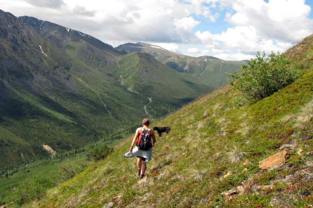
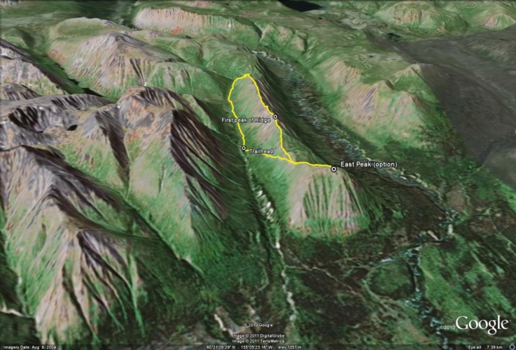
Red Ridge is a great ridge hike offering several options and fantastic views. The ridge is between other formidable mountains like Twin Mountain and Mount Perkins. Annie Lake can be seen from the top and the ridge follows along the beautiful Watson River Valley. The first part of the hike follows an old mining road for 8 km until you reach the hiking trail up the ridge. A portion of this road is drivable in a 4x4 vehicle with good clearance to cut off some of the hiking distance or consider a mountain bike.
Drive south from Whitehorse on the Alaska Highway and turn right at the Carcross Cutoff onto the South Klondike Highway. After about 17 km turn right onto the Annie Lake Road (which will quickly turn into a dirt road). After about another 17 km you will reach the north end of Annie Lake. There is a small pullout on the right and a rough trail that leads towards a marsh.
You can start hiking from there, or if you wish to drive a portion of the road, drive past the pullout for another kilometre and take the next side road to the right after a bend in the road. Stay on the main road at the fork to the left (avoiding the private property). This road goes for a little over 8 km to the base of the ridge, and crosses two creeks. It is not advisable to drive the whole road as it has become very rutted and overgrown, and the creek crossings may be impassable during certain times of year. You can drive the road for about 2 km until you reach some good parking spots.
Note: The first 8 km of the route, follows a rough 4x4 road. In past years, it has been driveable in four-wheel drive vehicles with high clearance. Under more recent conditions, the road has gotten quite rough and the two creek crossings have become more difficult. It may be worth combining driving part of the road and bringing a mountain bike for the rest.
From the parking area in the pullout beside Annie Lake Road, follow the 4x4 trail that crosses the marsh area. On the other side of the marsh, avoid the private property on the right by continuing straight, to stay on the road.
The first section of the road travels through the forest heading north with little elevation gain. The first water crossing is 2.3 km from the trailhead, and the main creek crossing is 3 km from the trailhead. Shortly after that, the road will head west towards Red Ridge and start to gain elevation. The road gets steeper in sections and then levels out as you follow along the side of the ridge. You’ll eventually come to a large clearing on the left (this is just over 8 km from the trailhead).
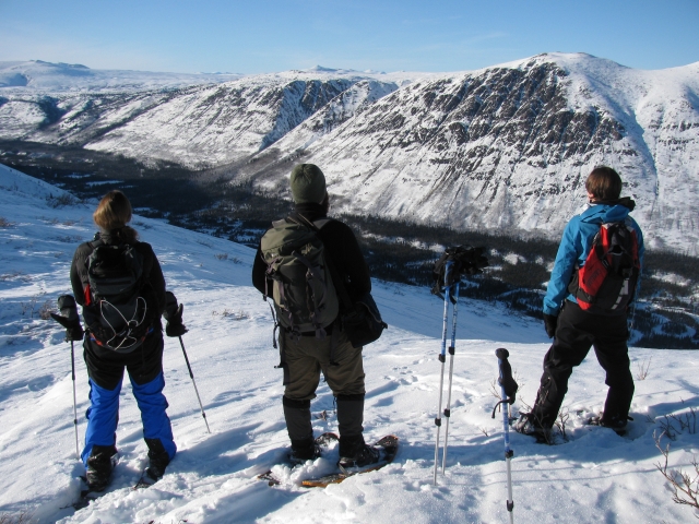
From the clearing, the main road continues west up the valley, but there is a smaller exploration road that leads up the ridge (on the right). Follow this exploration road about 2 km up to a small saddle. From the saddle the route to the main ridge heads west (left), but there is the option of heading to the East Summit for a side trip or for a shorter day trip if you don’t want to do the ridge loop. To go to the East Summit, keep following the exploration road to the right for 1 km. You’ll get a nice view overlooking Annie Lake and Gray Ridge.
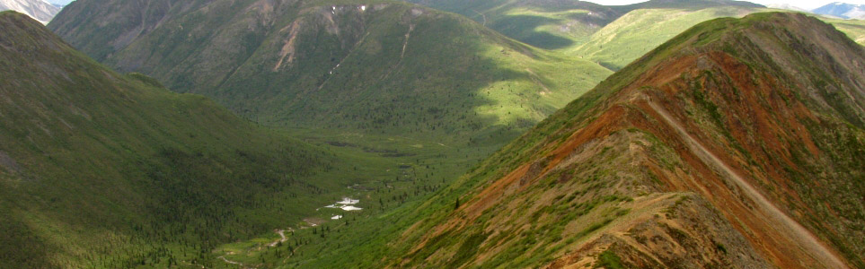
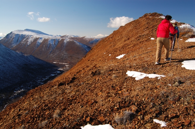
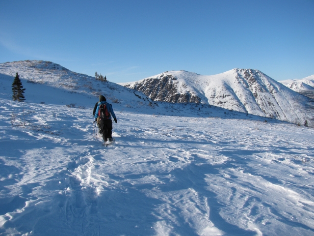
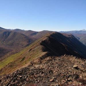
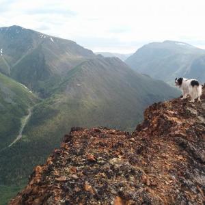
To continue along the main ridge that heads west, pick up a faint animal trail near the top of the saddle that traverses along the left slope of the ridge. This will allow you to avoid some bushwaking, at least for the first part of the hike. It is sometimes hard to keep to a main trail, but the ridge is open enough to find your own route as you try to make your way up to the first peak of the ridge. From this peak you’ll get a fantastic view to the west and it will now be easy walking along the rocky, red ridge.
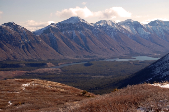
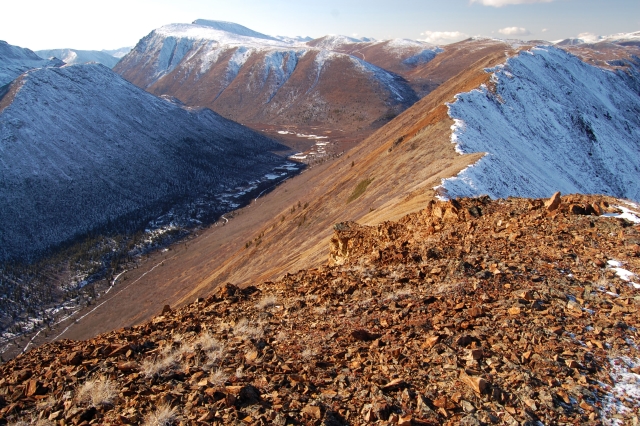
It is about 4.5 km to the end of the ridge from the saddle, with a bit of up and down. You’ll get great views into the Watson River valley on the right, and as you get further along the ridge, views of the Thompson Creek valley on the left open up as well.
Eventually the ridge levels out into a flat plateau where the trail disappears. You now have the option of either returning the way you came (which would involve a bit of ascent back up to the peaks of the ridge) or to continue along the plateau and loop down to the valley to follow a road back to the clearing.
For the loop down to the road in the valley, start your descent down the end of the ridge and try to pick up a rough road that switchbacks down the slope towards the left. This road meets up with the main road, which leads back to the clearing (just keep to the left). It will be about a 3.8 km hike on the road back to the clearing.
Hike all the way back down to the trailhead via the road. Or if you lugged your bike up to this point, enjoy the faster bike ride down.
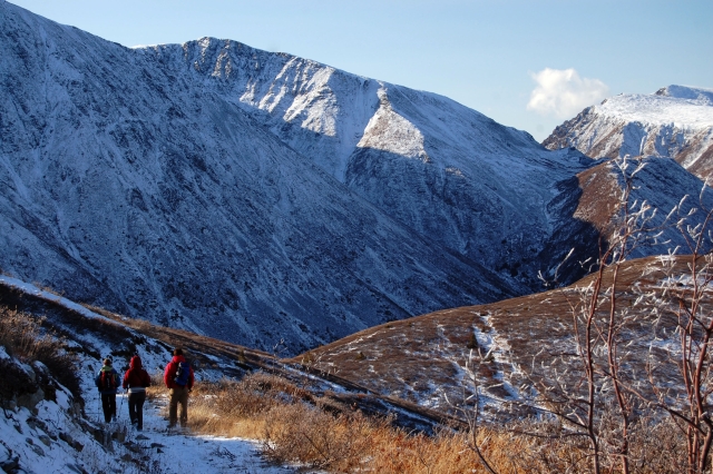
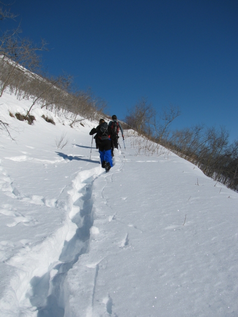
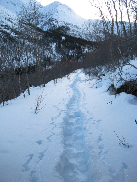
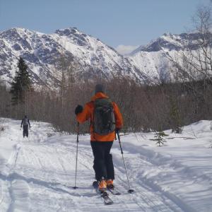
The winter trail is the same as the summer trail, but you will have to walk or ski the 8 km road instead of driving it. The road is often packed down by snowmobiles and dog-sleds. Once at the summer trailhead and parking area, the road up to the top of the ridge is steeper and the snow can get deep, so make sure to take turns breaking trail. It would make for a very long day if you attempted to hike the full ridge loop in the winter. You may only have enough time (and energy) to get to the ridge top and look over the other side before having to return.
Snowshoeing - Snowshoes aren't required to walk the road or the ridge top, but are neccessary for walking up to the ridge top from the summer parking area. Because you have to walk the road in the winter and break through deep snow, you can expect the trip to take 9 hours just to the ridge top and back. Make sure to take headlamps in case you get caught in the darkness.
Nordic Ski Touring - The road is perfect for ski touring because it isn't too steep. Skiing would make the way out much quicker than snowshoeing. It may be more difficult to ski up to the ridge top from the summer parking area, so you may want to bring snowshoes for this section unless you think you can stay afloat well enough in the deeper snow.
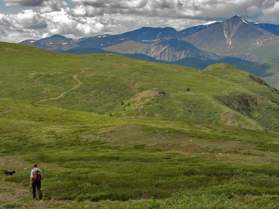
Annie Lake, as seen from the peak at the east end of the ridge.
Descending back down to the saddle from the east side of the ridge.
Following the animal trail from the saddle along the left slope of the main ridge.
Ascending along the ridge with the first peak in the distance.
A view of the spiny Red Ridge from the first peak (October).
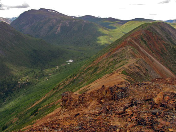
A view of the ridge in the summer (July).
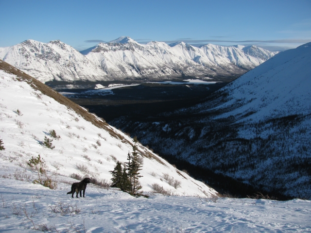
The Watson River with Goat Mountain in the distance.
Continuing from the ridge, down to the plateau.
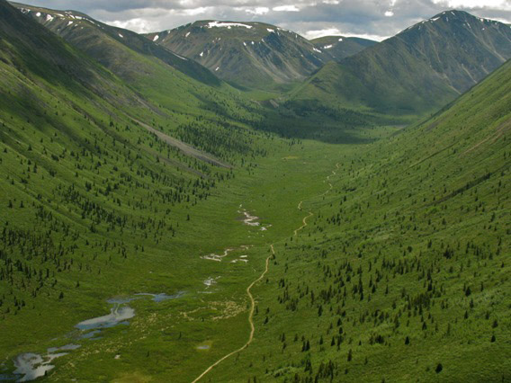
Views up into the Thompson Creek Valley.
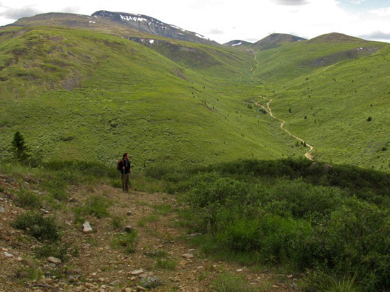
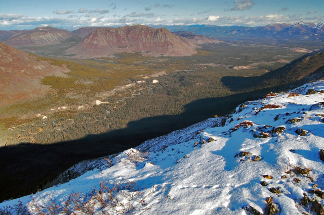
Looping down from the plateau to the main road (not shown in picture). The road you see in the distance follows Morrison Creek up to Mt. Hodnett and Mineral Hill.
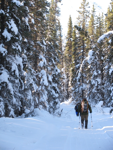
The road can be driven in summer, but in the winter you will have to snowshoe or ski up it.
The toughest part of the trail is walking up to the top of the ridge from the summer parking area in deep snow.
The wind-swept ridge top.
Looking over the Watson River valley.
The view towards Annie Lake and Gray Ridge.
If only you were so lucky as to find a trail already made for you.
Snoop September 11, 2022
Hiked east ridge on September 11/22. Amazing views and fall colours! We opted to park at the gravel pit suggested and then biked down the road about 200m to avoid the wet marsh area. We took the road noting trap lines in the area (not sure how they are this time of year). There are two creek crossings, the latter of which would almost certainly not be passable by a truck. The water was about half way up the calf, fast moving and a very rocky bottom. We biked to the trailhead, with a bit of uphill walking. The trail is easy to find and a fairly easy incline to the summit. The bike down was mostly downhill and really fun to cruise down! We would highly recommend this hike, especially in the fall.
Terry Joss August 26, 2020
Great trail, initial part of the trail head by pull out is swamped in, so go 200 meters down road to first road and follow that in. Creeks are crossable but if there's rain it will be tough and you will get wet feet. Other than that lots of puddles, and fun. I biked up all the way, so the ride down was super fast, great way to come home.
Justine Walton June 18, 2020
This trail is amazing!! We were not able to do the creek crossings in the Tacoma, so we crossed up-stream from the trail For both crossings and got a few boot “soakers”. Also worth mention that at the second stream crossing a bit up river someone has made a great log bridge a bit up-stream.
We took our bikes and were able to bike in about 4km, but then the trail was getting a little steep for my poor quads, and we ditched our bikes just past the old houses on the left.
Hiked the rest of the way to the abandoned mining camp site and then started our journey up to the ridge. We followed the trail up to the saddle between two peaks, adventured to the summit on our right for a great view of Annie lake, and the valley beyond. We then took part-trail/part-bushwhacking back down to the saddle and began the “ridge hike”. It took a while for us to find the actual trail, but it is there... it pretty narrow and looks like a goat trail. We used the “trail forks” app to check our gps location and found our way along quite well. Lots of different views and beautiful colours!
This is a long hike! From the first stream crossing, up the ridge (with a little diversion to the right handed summit) and back down the opposite side of the ridge and back to the stream is around 30km.
Bring bear spray; we saw a bear chasing 4 moose (3 babies) off Annie lake road, and saw fresh bear tracks while biking up the Red Ridge mining trail/road. Also, lots of mosquitos when you’re in the valley-we were well covered in bug dope, but still got bites.
What an amazing adventure!! Enjoy!
Pippa L. October 21, 2019
Skied/snowshoed from the Annie Lake Rd to the East Peak on Oct.20th. 7.5 hrs round trip. Entire road to summer trailhead had ATV tracks/ruts - hard-packed at first; snow got softer as we gained elevation. OK skiing on road (lots of rocks esp. on steep parts); nice snowshoeing on the ridge. NB: Creek is open and running high. We found a small bridge a short way upstream - good for hikers/skiers; would be a challenge with a bike.
Darren H July 27, 2019
Biked to the camp with two others with minor pushing on the steep washed out sections. Probably NOT ideal for 4x4. Hiked to the east summit and then the entire ridge. Weather was okay, not bluebird but the view was still very nice (do not agree with the post from Kyle regarding this). Round trip was 6hrs. Biking down was great! PS saw a moose on the switchbacks off the back of the ridge.
Kyle June 11, 2019
Very long hike with minimal views, I didn't find it worth it. The road to the trailhead is rough and the second creek is impassable. Doesn't matter what kind of clearance you have. Especially with the rain fall we've had, the water levels are high. To reach the saddle its 11.9km. With a 2-3km hike upwards to the east summit. So if your doing the "easy" east summit as I did its going to be a minimum of 28km. From this you only get a side view of Annie Lake.
I did some exploring and totaled the day at 33km in 6hours.
If you do the whole loop around the mountain your looking at 36km minimum.
Many Yukon hikes will offer you a better view after 1km...
David J November 20, 2018
Tried to do it today (Nov 20th). We park at annie lake and it took us 2h30 to walk until the trailhead. Snow very soft. We decided to go back at this point... Still 18km done but not the best part :)
Bryan W October 17, 2018
We did this trail on Oct 16 2018. Drove all the way to the parking area listed in the description. Not an overly complex 4x4 trail, but there are the water crossings, and if you value the paint on your vehicle don't do it, as there are lots of encroaching branches to give you lots of "pin striping". We hiked the entire ridge loop. It was pretty good, not much snow up on the ridge. We don't think it would be worth the extra 16km(ish) of walking on the 4x4 trail for this hike.
Stephane September 17, 2018
We hiked this trail on Sept. 16.
We were able to drive up to the second creek. It is a tough road, there are 2 critical spots and a pond you would not cross without a high-clearance 4x4.
From the second creek, we walked 26kms total. Long distance, rewarding views from the ridge! We spotted a herd of sheep on the East summit, saw bear scats on the plateau. Plus there are tons of cranberries on the ridge, allow 1 extra hour for the picking!
A beautiful trail...
Patrick September 16, 2018
Awesome trail! Insanely beautiful trail with great vistas on both sides of the ridge at the same time. Fairly easy to navigate despite no marked trail (you hop from one summit of the ridge to the next). I recommend packing a bike. Park right beside Annie Lake Road and pedal the remaining 8Km. Anyway, you probably won't be able to drive too far up this road. Lots of washouts and debris. Plus, some heavy rains a few days before made for pretty high flood levels. We stoped after driving 2K with a small pickup truck and biked the rest of the way to the trailhead. Left the bikes there for our hike. We had a fun time riding back to the truck! This trail is highly recommended!
Liz Sutton June 2, 2018
Sue Deforest and I hiked most of this today. The large tree that was down around the 3km mark has now been taken care of. We worked at it for an hour with a very small axe and hand saw but sure beat hiking the extra 16k of road. We came across a large herd of sheep with many young ones, so be very aware of you have dogs with you. Beauty views!
Randi Newton May 28, 2018
Four of us had an awesome day out yesterday. We parked at the beginning of the road to the trailhead, by the yellow trapper's sign, and biked the 8 km to the trailhead. There's some steep, loose, sandy sections and it's a long ascent so kudos to you if you make it up without having to push! The ride down would be a bit much for novice bikers, expect to walk in a few places if you're a newbie.
We popped up to the east summit first, following the exploration road the entire way. We then followed the ridge west, doing the loop described in the trail description above. The views are incredible and it's fun to eye up mountains for future trips. You'll have to follow some narrow animal trails through low shrub at the top so shorts would be a bad idea. There were a few snow patches at the top but they could easily be avoided.
Darren May 26, 2018
There is a tree down across the road at about the 3 km mark. It is unpassable with a vehicle.
Josie April 19, 2018
Response in regards to the log cabin along the trail to the trailhead...
This cabin is a trapper's cabin that continues to be used. The trail is an active trapline as well, so please keep pets leashed at all times. Please do not go near, explore, or touch any live traps.
There have been incidents of traps being sprung and people releasing trapped animals...please have respect for the trapline holders who have used this trapline for generations.
The trapline cabin is open to be used with respect. Replace what is used as soon as possible and do not leave a mess. Carry out what you carry in (garbage).
Carlos May 22, 2017
Went yesterday but ended up just walking the road a couple of kms beyond the mining camp. We parked at Annie Lk Rd and regretted not taking our bikes as it would have been a better ride than a long walk. Beyond the swamp at the Annie Lk Rd, watch for the yellow trapping sign and walk up the road to the right of it (roads branch off in a few directions). First creek was snow covered and could be driven over by any vehicle. Second creek was shallow and drivable by a 4x4 and easily crossed on foot over the plank that someone had laid down. The whole road muddy in places but passable. No wildlife sightings and only old scat. Good thing that it was a windy day or the mozzies would have had a feast. It would have been very windy on the ridge (and mozzie free).
Krista August 21, 2016
Really beautiful spot.
The 8kms (which was closer to 10kms) road to the trailhead is definitely not vehicle friendly. A quad is needed or add another 10kms to the distance of the hike each way. The quad trail isnt quite mountain bike friendly either.
Overall is a fantastic hike!
Joe June 5, 2016
Great hike! However do not expect to be able to drive to the trail head as the road is in very bad condition. Be prepared to add about 2 hours extra each way to your expected hike time, because it takes a while to get to the trailhead.
Does anyone know the backstory to the abandoned cabin along the road to the trailhead?
Erika September 20, 2015
Just did this hike today (Sept. 20, 2015) and biked to the trailhead, which was awesome! Gorgeous views, etc.
The road is pretty rough past the first creek crossing. We parked at the first creek as we did not have 4x4.. but even with 4x4 it would be tough. The second creek crossing is high at the moment and there's a fairly large tree down after it. If you are hardcore and planning on driving it, bring a chain saw!!!
Drew September 17, 2015
Hiked the Red Ridge on Sept. 13.
The access road is in relatively rough shape. I highly recommend taking a bike and biking to the trailhead. Its about 6km from the first creek crossing. It is uphill most of the way but a great time coming back down. Trail is easy to follow but does require a bit of bushwhacking once you reach the first saddle (start of the loop). If you want to connect with the rough road at the north end of the loop, make sure you walk all the way to the end of the ridge (it will start to drop quite a bit into a gully). There is a bit of bushwhacking at this point also.
Amazing views of the watson valley - brilliant colours this time of year. Great hike - highly recommend.
Adam July 6, 2015
Went up and along the ridge yesterday. The access road was definitely impassable at the second creek crossing, adding another 6km onto the approach to the trailhead. Also, the mosquitos were almost enough to make some turn back. I'm glad we didn't, because the ridge was beeeaaaautiful. Plenty of cell reception to call your mom.
I think this trail would be a perfect after-work-going-till-late-bike/hike combo.
Coral June 28, 2015
We just returned from hiking this trail. After some near-perils along the access road, we made it to the trailhead and enjoyed the ridge hike immensely. I did the drive in my Rav4 (with 4x4) and my clearance was almost not enough (although the creek crossings were fine, they may not be another time of the year). I definitely advise good clearance and 4x4 as parts of the roads are ROUGH.
No bear sightings or fresh scat but lots of moose, sheep and elk tracks. Overall, a special place with special views- enjoy!
Rick Oliver May 24, 2015
Sunday May 24 2015. We made it across the first creek, cold and clear, in our jeep. The passable road ends a bit further in. The road goes through a bog where a deep mud puddle full of rocks has been developed by vehicle traffic. We did not chance a crossing. We knew it was going to be a long walk in.
We were about to head back out and find another hike closer to the road, when two vacationing kiwis showed up. So not to be out done, we joined parties and headed in on foot. The round trip was just over 20 k from where we parked. The second stream was a torrent of melt water. About up to our knees and several lanes wide and cafe aux lait color so a stick was needed to gage the depth. Mister Misty headaches on the legs!
Then a long walk through the trees to the "trailhead". Good walking all the way. We Made it to East Summit for the beautiful views. Visibility was unlimited. Temperature was about 25 to 28 C. Mountain bikes would have made the long road in much more enjoyable.
Marko Marjanovic March 23, 2014
We ski toured the road from Annie Lake up to the trailhead for Red Ridge today. It took about 4 hours return (we didn't actually climb up Red Ridge). The snowmobile-packed trail made the skiing pretty easy.
sam bannacci September 8, 2013
has anyone done this in Sept? wondering how the road access is ? we have 4 wd but no winch
Sue August 31, 2013
Tried to get in with our truck today and couldn't get past km 4.5 due to a pretty bad mud bog
Pippa July 23, 2013
Hiked up the East Peak today (July 23rd). Second creek was a raging torrent, so we parked there and forded it on foot. Made for a much longer approach on the road.
Deb May 3, 2012
would like to do this hike on Saturday. Has anyone done it lately? Just wondering if the ground has firmed up yet?
Thanks.
