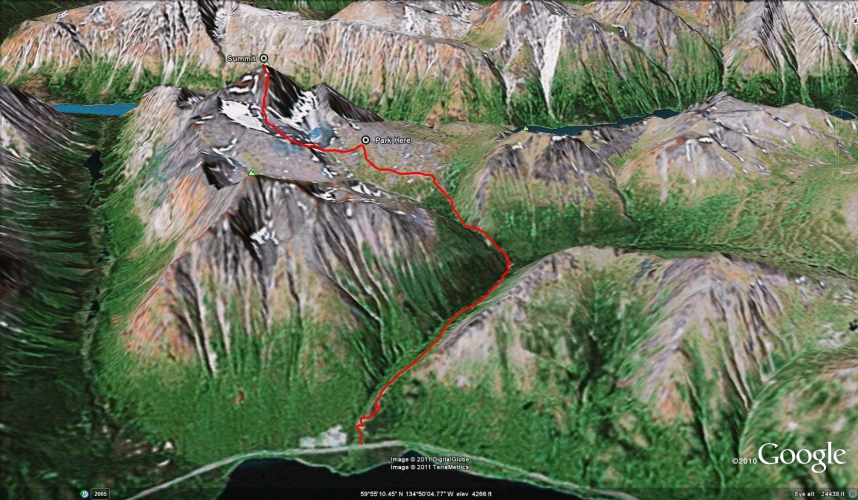
Total Distance: 6 km
Return Time: 3 hours
Elevation Gain: 626 m
Difficulty: Moderate
Region: Carcross
Traditional Territory: CTFN, TRTFN
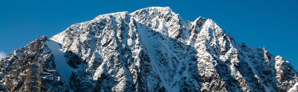
Paddy Peak is the highest mountain south of Carcross along the highway to Skagway. From the top, the views of mountain tops and the southern lakes seems endless in all directions. There is a 4x4 road from the highway that gains over 700 m of elevation, making the hike a quick scramble to the peak if you decide to drive. If you decide to hike the road, add 14 km to the distance and 3-4 hours to the hike.
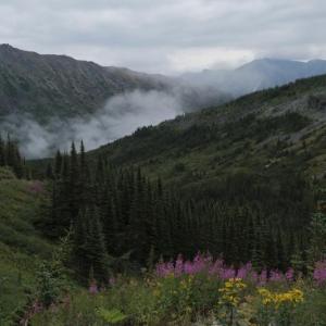
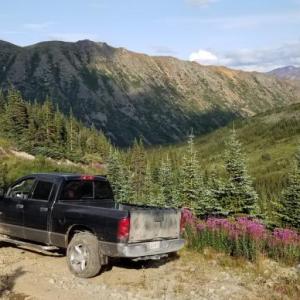
From Carcross, continue on the South Klondike Highway towards Skagway, Alaska. After 38 km south of the Carcross Bridge, you will see a rough gravel road on the right side of the highway. It is just before a creek and gravel pit.
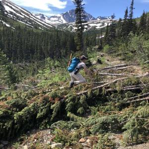
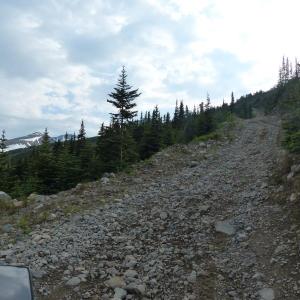
If you have a 4x4 vehicle with good clearance, you can now drive along this rough road for up to 7 km into the alpine. There are some very rough sections with steep slopes and larger cobbles and boulders. The road has deteriorated a lot over the past several years so use at your own risk. You could also consider a bike or e-mountain bike for the road access.
Note there is a creek crossing along this road which is a little tricky - with some larger rocks. Most trucks or SUVs with good clearance shouldn't have any trouble with the creek crossing. Park after 7 km (or when you feel you've cheated enough by driving and want to stretch your legs). If the road is muddy, you may not be able to drive up the last steep bit and will have to park and walk. There are some old exploration relics after the creek with a suitable parking spot.
The first thing you have to do is cross the stream that runs down from the glacial lake below Paddy Peak. The stream is below in a gully between where you parked and the rocky moraines to the south. If the water level is low or there is still a lot of snow, you can cross at any point. Otherwise you can walk up towards the glacial lake, which is situated right at the base of the rocky face of Paddy Peak and hop across the rocks there.
Make your way over the moraines to the steep ridge next to the rocky face, which leads up to the summit. This is the steep, direct route up to the top. An alternate route may be to circle around the full ridge above the glacier (though this could be more technical).
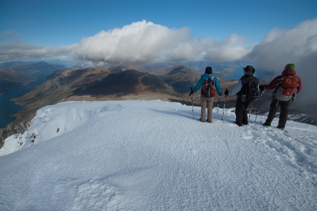
The route suggested here is steep but straightforward as you climb up the rocks. Watch your footing as these are quite loose. If there is enough snow, the route is even easier and you can just climb straight up. You will know you've reached the summit when you get to a Yukon Amateur Radio Association (YARA) repeater station (note that YARA and some other groups refer to this mountain as Mount Panacea, but that there is no official name).
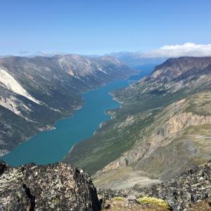
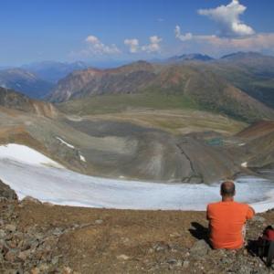
The views from the top are breathtaking of Bennett Lake to the north and Lindeman Lake to the south. Going down is easy if there is snow, otherwise the rocks can be slippery.
If attempting this route in the winter, be sure to checkout the Yukon Avalanche Association website for their 'Avalanche Terrain Ratings' Maps - ATES (yukonavalanche.ca/ates). They have mapped this area. Many backcountry skiers and snowboarders and snowmobilers go to the area called 'Powder Valley', the valley on the right after you cross the main creek crossing on the road. The first 1-2 km of the road is within 'simple' avalanche terrain. But as soon as the road travels below the Tutshi Bend ridge you are in 'challenging' avalanche terrain below a very steep, rocky, gullied ridge. Once past the plateau where the road ends, the slopes of Paddy Peak are considered 'challenging' and 'complex' avalanche terrain.
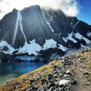
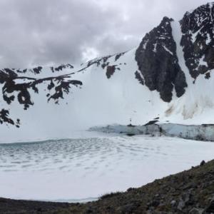
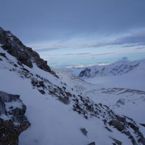
The steep north-east face of Paddy Peak.
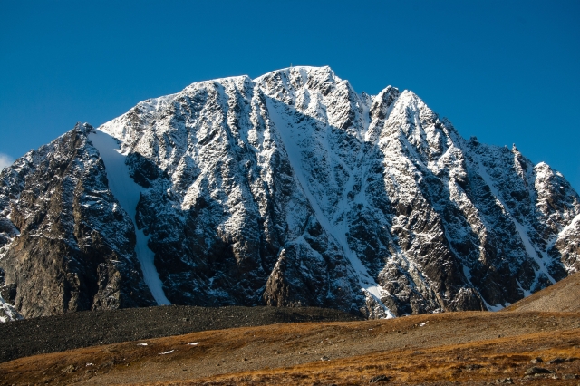
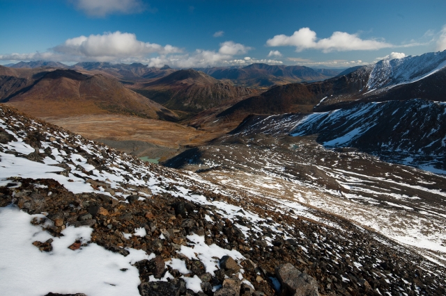
The start of the trail crosses glacial moraines. The slope to climb funnels up from the center. There is a glacier below the ridge on the left.
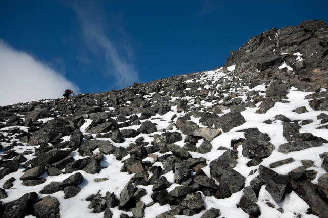
Climbing the rocky slope to the top.
As you start climbing, the view to the east opens up.
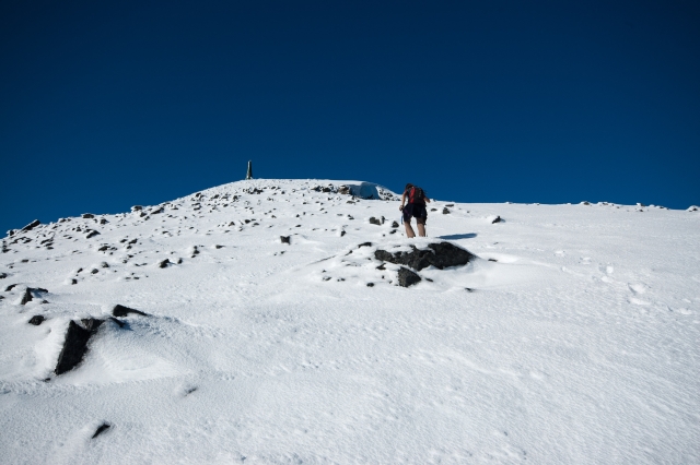
The final push to the summit with a repeater station on top.
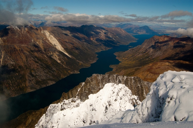
The view north from the summit with Bennett Lake below.
The view south. In the left-center of the photo, where the two lakes meet, is the old Bennett townsite (the end of the Chilkoot Trail).
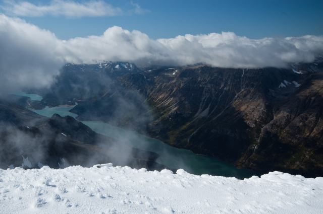
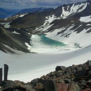
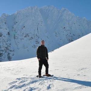
A snowy summit and a view north towards Carcross.
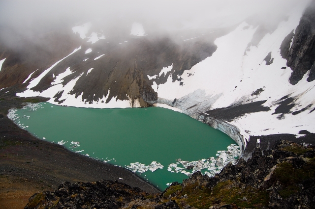
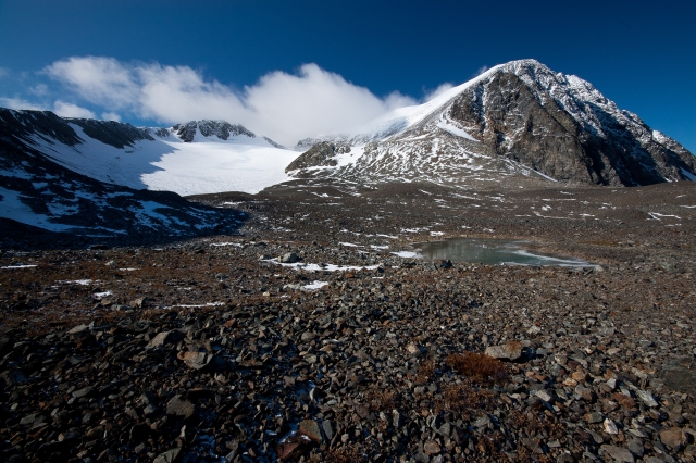
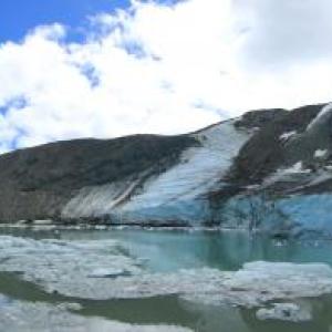
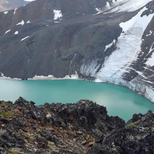
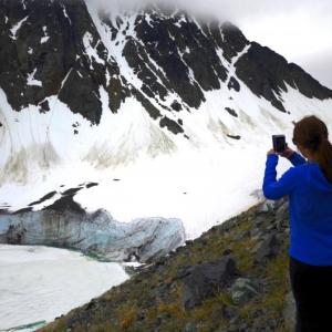
The glacial lake below the rocky face, complete with floating icebergs.
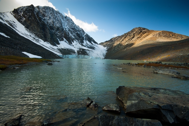
Looking at the peak from the shores of the glacial lake.
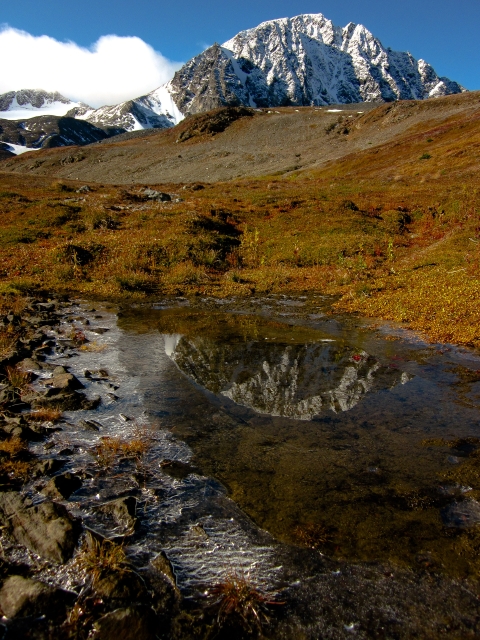
The frozen reflection of Paddy Peak.
Rhiannon August 19, 2024
Hiked this Aug. 18. We parked at the highway, which made for a very long day—about 21km. The ATV trail is very rough, rutted, and overgrown. From the alpine lake, the entirety of the hike is on loose rocks. It's challenging, fatiguing terrain. I recommend hiking boots rather than trail runners to protect your feet & ankles from sliding, sharp rocks. I brought my dog and her paws got some minor abrasions. The views from the top were absolutely incredible, but I think this hike is a one & done for me!
Louise July 27, 2024
Hiking this a couple of weeks ago, there hadn’t been any comments recently so we thought we might be able to drive up in the truck but we only made it 1km on the road before we had to park the vehicle. Expect a longer hike unless you have ATV or similar. Other than that I agree with all the info below.
Lily July 5, 2023
Hiked this trail in a group of 4 and 2 dogs on July 2. We hiked from the road (which we would recommend instead of driving), and camped at the lake - which was a stunning campsite! There was one creek crossing, then 2 smaller streams, so that was great to have extra water for the dogs. The next morning, 3 of the 4 of our group summited. The trail from the lake to the summit was only partially snow covered in patches, and the loose jagged rocks otherwise were not great for the dogs. We had excellent weather and trail conditions. Saw lots of other hikers, but had the lake to ourselves for the night. There was lots of bear scat on the trail, and we saw a bear close to the trail head when leaving. Overall, an awesome hike and great couple days out!!
Ben Feltmate June 14, 2023
Hola!
I lost my phone on the Paddy's Peak road between the highway and the creek. There's a $300 reward for anyone who finds it. Black Samsung S10. If you find it, please let me know, it would mean the world to me :)
Thanks!
Ben
Ben Mercier July 9, 2022
Don't bother trying to drive the first 7 KM in a truck. The trail is narrow in some sections with alders creeping in so you'll be scraped to death. Immediately after the first creek (about 3 KMs) the road has been partially washed out and is impassible with a truck. ATVs can still make it to the top.
The walking on the mining road is easy and worth it when you finally do get to the alpine. Sweeping views all around and a really cool glacial lake.
Cody August 12, 2021
Hiked this on Sundays, road is okay to 4x4 drive at least to the creek or to the core logging station if you're up for more of a bumpy ride.
Made it to the glacial lake in 2.5 hours at an easy pace
Robin Snark July 2, 2021
We rode/pushed bikes up from the highway. Stashed them at the creek crossing. Continued on foot to the alpine. Riding down at the end of the day was fun!
There is significant avalanche debris along the trail between the creek crossing and the alpine. Not passable in a vehicle right now. The road surface is pretty poor along this section anyway: loose, rutted, with water flowing down it. Would be a hell of a drive in most vehicles.
Make lot's of noise! Bears are feeding on the fresh growth along the trail. We saw one black bear, twice, feeding at the same spot.
Good hiking boots suggested: there's lot's of snow and mud in the alpine still. Runners would be wet and messy.
Beautiful wildflowers and views and quiet!
Erin June 29, 2021
Went to quad to the base of the hike today and the creek crossing is EXTREMELY high currently. Didn’t want to risk getting stuck in the creek or water logging the quads. FYI for anyone planning on quading or driving up there!
Erica December 31, 2020
We drove up in our Jeep and stayed the night at the bottom of the hill that I believe Lexy is referring to. (It's steeper than it looks.) We may have been able to make it, but we don't like to chance things - plus we were traveling alone. Beautiful area :)
Digitgiyáa August 31, 2020
August 30, 2020
Hiked and overnight camp at glacier lake.
Sadly I found garbage!
Trail is eroding from sooo much 4x4 !
Just a reminder of fragile environment and animals are push away from their home, sooo much traffic! Hike! Walk and connect to the land. If you see wildlife keep dogs under control! Birds like ptarmigans are all over now! Glacier has significantly shrunk, so appreciate and memorize this beautiful glacier before is completely gone!
Hiking this beautiful place since 2007 ! Changing fast! Let’s keep it WILD & CLEAN!
Lexy August 30, 2020
This hike has proven to be my favourite so far. I highly recommend this hike as the views and scenery are breath-taking.
We hiked the 4x4 road to the glacier lake. I would love to clear up some of the comments below. Yes you can still quad, dirt bike, and drive a 4x4 vehicle up to the lake. However, you will need some courage and experience or just guts. I have experience off roading, but my personal opinion would be to only drive as far as the first creek crossing (not sure but I think it is 3 km or 4km in), as after that there is a very steep gnarly hill, and it definitely is not a novice hill for a vehicle, quad, or dirt bike. For the majority of people I would suggest all vehicles park at the bottom.
Once at the glacier lake there is a lookout to the right. To the left of the lake is the actual Paddy Peak summit. If you want to summit this hike be prepared for snow and bring warm clothes. We did not do the summit, but this hike is still worth it to see just the lake. If you hike from the bottom it should take about 3 hours to reach the lake.
There was a black bear off the 4x4 road. It had a healthy fear of humans.
Happy hiking!
Eleanor August 15, 2020
Did this hike with a group on August 8th, started from the highway and didn't quite get to the lake. Saw lots more people doing this hike as well some doing overnight trips. No sign of bears. Definitely recommend.
Danny July 3, 2020
Attempted this hike on June 2. I do NOT see how any 4x4 truck could get up that road - it is steep and very bad. I've heard even quads have difficulty. I drove a little less than 1km up the road and parked. Then I only hiked an hour up the road before spotting a bear (grizzly, I'm sure) just off the road (as well as bear poop along the road, naturally). I didn't get a clear look at all, but I've heard a big guy lives up there. Will try re-doing the hike in a group. Beautiful area.
Jackie H May 11, 2020
Attempted this May 10, only made it about 2.5 kilometres along the ATV road. The trail's clear for the first few hundred metres but otherwise, there's still a decent amount of snow on it. I postholed up to my waist in some places. There were also multiple streams of meltwater running down or across the road, turning the non-snow-covered bits into muck, especially in the afternoon. Gorgeous views but I'd strongly recommend giving it another couple of weeks, or at least bringing snowshoes. And don't even think about driving up the ATV road unless you've got like 3ft of clearance, it's far more rutted than when the trail description was originally written.
Maggie August 4, 2019
Beautiful hike. Long road to climb but worth the climb for the views at the very top and along the way. Some comments are very misleading... there is no way your typical vehicle is making it anywhere near the trailhead. We took an SUV with 4x4 and didn't make it past the first 800metres. Saw some sheep. We took the peak just to the right of Paddy peak due to time - still has gorgeous views of both lakes and the glacial pool. Give yourself time for this hike and you will likely be hiking the 7km road up and back.
Ryan July 27, 2019
Road is still doable up to the last climb in anything with a bit of clearance and 4x4. The last climb is too rutted now to get a full size truck but you might be able to still get a Jeep or mid size pickup up there.
Kyle September 24, 2018
Hiked on Septembre 21st,
Had to walk the first 7k of the hike to get to the trailhead.
Not a great time, the road is very rough and torn up by so many
ATV's and Mules going up to the trailhead. Feet were pretty raw after the hike.
The hike itself from the trailhead is nicer, can go either way as well. Can go to the right of paddy's peak which is the trail in the description and get views of lake Bennett and the glacial pool. Can also go left, there are many game trails. To the left you can hike up the mountain beside paddy's and see two more glacial pools. A large creek is in between the mountains as well. Some snow at the summit now too.
Saw a herd of sheep going up paddy's peak.
There also seems to be an operation at the start of the hike, might be able to rent ATV's and Mules. There was several of them there.
Total for hiking the left side of the mountain and paddy's peak was 33km and took 6.5 hours.
Torey August 22, 2018
Grain of salt: I am new to the Yukon, and based on the other hikes I've done, I am not as 'adventurous' a driver as most of the hikers of yukonhiking seem to be.
The "trail"or "road" up to the glacier lake is more of an ATV trail than a hiking trail or road. Driving it would require guts and 4 x 4. We saw a truck that had broken down on the journey up, and one that made it halfway (to fish) - otherwise only ATV's driving up. There are very steep sections, it's very narrow for vehicles, and there are very few places to turn around or give space if another car was driving in the opposite direction.
You can certainly hike it (we did), but I find walking ATV trails not as nice as footpaths. Although, the width means you can walk side by side with a group!
We camped and hiked around the area. I suggest sticking to the (relatively clear) trails or flatter areas. Heard lots of loose rocks falling overnight, and ice breaking! My friends and I went to explore different areas and ended up on a section too steep with too many loose rocks: great views, but dangerous.
Overall, gorgeous place. Take your time because some areas are deceptively steep. Worth the visit / hike! I wouldn't drive to the "Park Here" spot, but the hike isn't too long.
Jack Morrison July 7, 2018
What a beautiful Trail.. great hiking trail up into the alpine to see glaciers and lakes. Recommend this trail to everyone. Can totally drive an ATV up there and explore all over wherever you want! So much fun! You can drive anywhere you want without getting stuck:)
Leah June 21, 2018
Amazing views! We went up June 20th for our own little solstice night.
I have to say...Southeast Tours is destroying the trail. Huge ruts and ripped up sections of the trail this year compared to last year. They went in way too early this year with cat to plough it and just destroyed the ground. Such careless use of the trail. It’s so sad to see.
Anyone know who I can get a hold of to report this? I called southeast tours and they didn’t care at all :(
Yukoner May 29, 2018
Is Paddy Peak in Yukon or is it in BC?
Liz B September 21, 2017
My husband and I hiked here on September 20th. The "road" off the highway is very rough, I would only recommend driving it if you have a high clearance 4x4 vehicle. We have a Nissan Xterra and bottomed out in some of the rocky sections (river crossing was no problem). We were unable to drive up the steep hill near the end and ended up parking around 5.5km up the road. We encountered 3 side-by-sides full of tourists as well as a couple ram hunters on ATVs, none of which took away from our enjoyment of the incredible views. We also saw lots of sheep on the mountains around Paddy Peak. All in all a great hike, just make sure you're confident in your driving skills and have a spare tire if you're going to attempt driving in...
Darren July 23, 2017
Had a great hike today from the highway up to the plateau with some going a bit further to the ridge above the glacier.
Would not recommend driving in - road is rough and getting worse. The hike makes the scenery even better.
The ATV tours with cruise boat traffic was a bit of a shock to see and they are driving off road as I watched with my binos from above and saw the tracks on the ground.
A small group of caribou spotted away from the plateau and away from the ATV's which must cause a disturbance. Cannot agree with comment from Bill... sorry.
Bill May 14, 2017
Yes, we drive ate tours up here. We have permission from BC and TFN. I agree the orange paint is bad and will remove the rest of it this season. For those who claim our tours are "destroying" the area, I respectfully disagree. I have always believed that people without the time and or physical endurance to hike still deserve the opportunity to experience nature's beauty. Imagine what Paddy Peak would look like if gold had been found in profitable quantities.
una May 14, 2017
Looking for people who want to hike this trail, drop me a email if someone interested do it together before the end of May. . I am traveling in Yukon now also interested do other different hikes . unazphoto@gmail.com
Aaron September 18, 2016
I did this hike a few weeks ago. Andy is correct that there are tracks off the trail. And someone sprayed a bunch of neon orange spray paint near the glacial moraine. Someone is operating a tour up there I hear. Perhaps the BC government should put an end to it.
Andy September 5, 2016
Drove up to the last steep section on the road past the washout. Scraped bottom a few times on the washout. Wandered around on the plateau and found a Jeep mudflap and tire tracks several hundred meters away from any road... If you drive up in to the alpine, PLEASE STAY ON THE ROAD!
Deb August 8, 2016
Drove up the road on August 7, 2016 with a Jeep TJ Rubicon. Would not have wanted to do it in anything less capable - as reported by Kevin, pretty steep and scrabbly in spots.
Absolutely stunning up there, recommended.
Kevin August 8, 2016
Driven the road up this past weekend with a enduro bike. No problem getting up. Road is in pretty good shape but can get quite steep in places which could get challenging with a vehicle. The views at the top are amazing. Wish we knew about this trail earlier.
mary tucci August 7, 2016
Has anyone driven up the paddy peak road lately? We have driven it in the past in a 4runner as far as the washout but have heard the road is a lot worse lately. Any updates would be appreciated. thinking of going next weekend if the weather cooperates. Thanks!
Laura August 2, 2016
This is a fantastic hike! We hiked up from the road instead of using a vehicle and camped overnight about 1 km before the parking area at the glacier. We met some new friends (experienced hikers familiar with the area) who hiked with us up to the top of the glacier to the notch between Paddy Peak and the ridge to the north. We proceeded to hike the ridge to the north of Paddy Peak and then back down to the parking area. Views were spectacular in every direction! Note: Hiking this ridge was challenging and could require climbing gear on some sections. It is advisable to refrain from hiking the glacier or the ridge unless you have pristine conditions, which we luckily had that day!
Need the D July 18, 2016
pretty easy to access trail with atv. Wash out is pretty low. Seen some caribou
Justine June 12, 2016
Tried out the drive to the trailhead today, June 12th, I have a Ford Escape and I felt pretty bold and was white knuckling in some areas. I made it 5.5 kms up the road; the road is steep, there are some large rocks, a river, a stream and a dried up creek bed (which I think may be responsible for some fixing had to do on my bumper when I got home). I stopped at a steep slope with a few really large rocks that my SUV, and my nerves could not handle, I went back to a pull out and parked. I then hiked the rest of the way into the glacial lake.
There is still a bit of snow there, but you can mostly hike around it (my car would not have made it through that). The lake still has ice on it, but is breathtaking! Paddy is also just breathtaking to look at!
Instead of going to the left of the lake I went to the first summit on the ridge to the right and stopped for a break there before heading back to my car. You have a great view of, I believe, Bennett Lake there!
I would recommend bringing warm clothing in a pack, as I did get caught in a snow squall for about 10 minutes, but dressed appropriately it was not a problem.
Time from 5.5km road to right ridge summit and back: approximately 1.5 hrs
So worth it!!
Jennifer June 6, 2016
Attempted this trail first week of June. Thought it would be a quick, moderate day hike. Despite what the description says, you cannot drive very far up this road. Big rocks, big holes, washouts, etc. we had an SUV with good clearance and 4WD and made it less than a kilometre. I can't see anyone successfully driving this road without an ATV. Hiked up the road for 2 hours before we hit snow and the clouds rolled in with rain. We have no idea how close we were to the trailhead because we couldn't see the end of the road, even in the alpine. We turned around at this point as our party was cold, wet, and disappointed. If we had known we would have to walk 12 km round trip, prior to even reaching the trailhead, we would have tried a different hike. Just thought I should share that with others considering this trail.
MeghanM May 27, 2016
Myles, sounds like you ended up at the gravel pit after the road to Paddy Peak. It's the small obscure road just before the gravel pit, before you cross over the creek on the highway. You can also take a closer look at the google earth image above.
Myles May 26, 2016
Hi guys, we're thinking about doing this hike this weekend. The only problem is we went to this site a few months ago and couldn't find the road you're talking about. I turned into the gravel area at KM 38 (after the Carcross bridge) and couldn't find a road to go up. Were we in the right spot? It was a rather large area with a few mounds of gravel.
MeghanM May 4, 2016
With a low clearance vehicle you should probably just park at the highway. The road is pretty rough and steep in places, even after the first couple hundred metres. So that adds 7 km to the trek in, plus 7 km back out. A mountain bike could help speed things up.
CM May 3, 2016
How far can you drive in if you have a vehicle with low clearance?
Veronika October 13, 2015
I love the trip to Paddy Peak - for me, the trail description doesn't emphasize how beautiful it is just to go to the lake and see the small glacier! One of my favourite spots.
Not able to cross the creek with an SUV, even if we had we wouldn't have got much farther up the road with my clearance.
Attempted to hike to the peak but there was a lot of snow/ice and the wind was something else. I would recommend some crampons if you are going up at this time of year.
The snow is on the ground as soon as you reach the alpine.
Jazz June 18, 2015
Can we now park again on the point indicated on the map i.e. was the washout "repaired"?
Planning to do this in the next few days.
JS June 14, 2015
Was up in this valley over the last few days doing some skiing on the higher snowfields/glaciers. Road is now open to alpine with only a few small snow patches to cross by foot. I was unable to cross the first big avalanche paths only 2 weeks ago due to a late April avalanche cycle which produced a few size 3.0(large enough to break a few trees) avalanches. Flower show is impressive at lower elevations, but starting up high. Minimal bear sign observed. I have to throw down some clarification- this area is in BC, just saying. Confused as why this isn't labeled as a BC Hike once past Dall Creek it is BC all the way to AK- always has been, always will be. Cheers.
Mike December 8, 2014
Attempted to go up to the peak this past weekend (December 7th). Second time up per previous post.
Temperature was great but the snow wasnt so much for snow shoes. Trail was sled packed up to the second creek crossing. This is where the snow has a slight bit of crust but not enough yet to keep you afloat. Was a tough slog to the other side of the glacier valley.
Extreme winds and sleet kept me to only halfway up to the ridge. Weather turned pretty quick and followed me back down to the highway.
Though much colder it seems a better winter hike early in the new year than it is now and I would suggest waiting.
sam July 29, 2014
If you drive 4 km up the road as far as the wash out are you still able to turn a vehicle around and get back out? Hoping to do this sunday weather permitting.
Chris B July 24, 2014
Very beautiful area. The road up is washed out 4km from the Highway. Recent bear sign was visible all along the road - at least as far as the treeline.
chris July 13, 2014
We tried to head up to paddys today. You can only drive 4.5 km up the road now as it has been washed out by all the rain we have had. The step in the road is waist deep. Had a fun day tho, its a great spot. You just can't cheat as much anymore.
Cody July 12, 2014
Hiked up this last weekend with some friends, amazing views it was a great hike. The road there was pretty freaky, looked like a quad trail but we made it through in a truck with surprisingly no scratches. I highly recomend doing this hike!
Mike February 23, 2014
Hiked up to Paddy's Peak this morning starting from the highway. Followed snowmobile tracks up but broke trail from the core sample piles up, snow was only about 6 inches of powder over crust which was good going up but terrible coming back down. Base of the peak is wind blown and icy. Didnt attempt the peak as I didnt have crampons and the snow shoes were too cumbersome to try. Was a great, cloudless day but about -20 to -25. Started at -37 at the highway.
Murray Lundberg August 16, 2013
I spent the past couple of days exploring up there. The second day, I'd planned to get to the summit via a scenic tour starting at the non-glacial lake to the east. I parked at km 7.0 on what a 2007 geology reports call the Bennett Plateau 4x4 road, at 1,472 meters, and walked from there. However, what appears on the topo as a reasonable route above the glacier to the southeast of the summit is actually not - the top of the glacier ends at sheer cliffs. The ridge to the east of that glacier, however, was a superb route down from the dead-end.
Eleanor June 23, 2013
Hey, did this hike yesterday. it was awesome! ... we could only drive in about 1 km with our little rear-wheel truck. the road was quite rocky on the hills—probably wash out. So the whole day took us ten hours return. You're right that going down was the tricky part, not because the rocks were slippery but because they were so loose. we sent a few big ones rolling down the mountain—but we were spread out so it was okay.
ugh-maze-ing views on top!
