Total Distance: 22 km
Return Time: 2-3 days
Elevation Gain: 940 m
Difficulty: Moderate
Region: Kluane
Traditional Territory: KFN, WRFN
Nines Creek South weaves its way up through two small canyons before widening out. The wide creek valley is easy hiking surrounded by beautfiul Kluane mountains. Near the end of Nines Creek South, where the creek splits, you can climb to a spectacular alpine area with many little lakes and large mounds to explore (highly recommended). If just hiking Nines Creek South (not to the lakes), it is 8.4 km (one way) with 540 m elevation gain. Hiking to the lakes adds 2.4 km (one way) and 400 m elevation gain (about 1.5 hours extra one way).
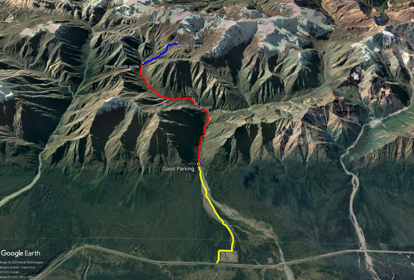
Drive 97 km north of Haines Junction on the Alaska Highway. Continue 9 km after the Congdon Creek Campground, look for a gravel road on your left. Take this road and follow it around the gravel pit. The road bends right after 400 m, and after another 400 m look for a road on your left, before the end of the gravel pit.
The road can be driven 4.3 km to a suitable parking spot, even in a small car. If you drive any further, you may end up in an active mining area, so best to park your car before this.
NOTE: This hike is within the Kluane Wildlife Sanctuary and not in Kluane National Park & Reserve.
The return distance is from the parking spot to the alpine lakes above Nines Creek South.
Start by hiking along the rest of the mining road. From the parking spot, you will soon reach the main mining area, and then shortly after you will be forced along the left bank of the creek.
Continue following the mining road when you can. There are a few short sections that require you to go into the trees, but there are paths through them.
Eventually the creek valley will widen and you can walk on the rocks beside Nines Creek. Then you will come to a point where two valleys meet in a 'Y'. The left branch is Nines South, the right branch is Nines North. Follow the left creek.
After 1 km, you will reach a canyon. If water levels are low, you can hop across the creek in the canyon. If water levels are high, you can climb up onto the right bank before the start of the canyon. There are some interesting rock pillar features in the canyon.
Continue up the creek from the canyon. There is another section up ahead where the creek runs against the rocky right bank, forcing you to side-hill on a loose, rocky slope on the left bank. This is the most difficult section, so move carefully when side-hilling.
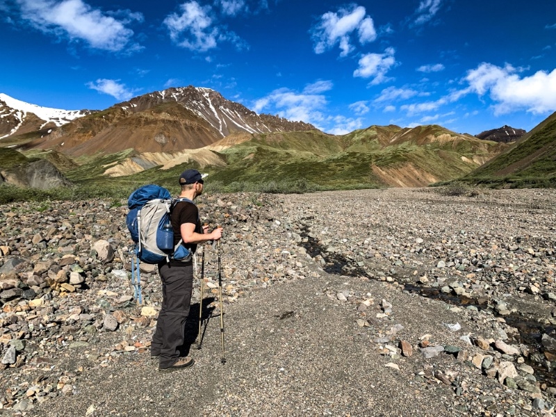
From here, the creek valley widens and it is relatively easy walking up to the end of the creek valley. It is 5.4 km from where Nines Creek splits into North and South to near the end of the valley, where the creek splits again.
When you reach the point where the creek splits, turn right and follow this creek about 500 m before leaving the creek and entering the bushes. You are aiming for the vegetated ridge up on the left. Pick your way up through the bushes until you reach the alpine where the hiking gets easier. Zigzag up the ridges until you reach the top, where interesting mounds dot the area amongst pockets of little alpine lakes. Explore the incredibly beautiful area. It is 2.4 km and 400 m elevation gain from where Nines Creek south splits, to the alpine lakes.
If camping, this is a picturesque area. Find a dry, flat spot to camp. This is an option to drop down to the valley beyond the lakes the next day, or even hike up and over a pass to connect to Nines North.
LOOP OPTION
See the Nines Creek Connector route on the website to connect Nines Creek North to South.
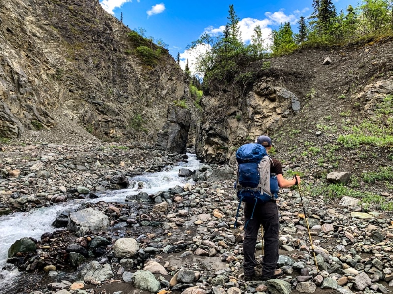
Shortly after leaving the Y where Nines Creek splits North and South, you will reach this canyon. If water levels are low, you can cross the creek, otherwise go up the right bank.
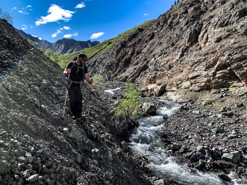
Another canyon higher up requiring some delicate side-hilling.
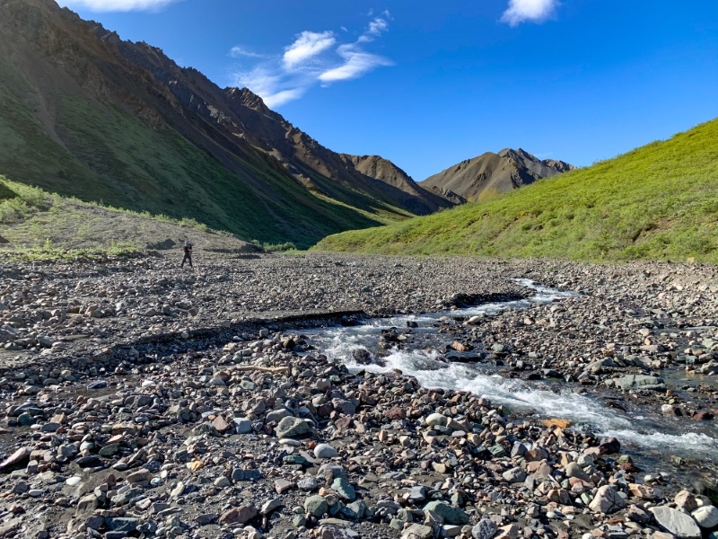
Nines Creek South opens up into a wide creek valley after the canyons.
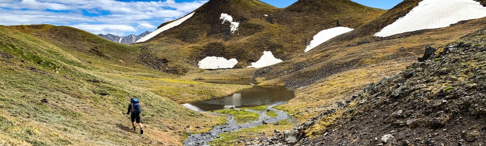
At a split in Nines Creek, take to the vegetation and climb up to the alpine lakes.
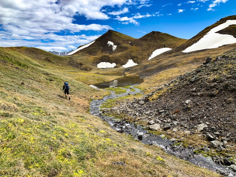
High above Nines Creek South are many alpine lakes and large mounds to explore.
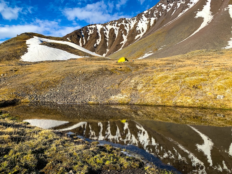
Camping at the alpine lakes.
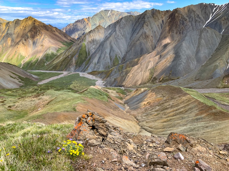
A typical Kluane landscape that you can never get tried of. Nines Creek South down below.
Pamela Battiston July 11, 2026
I have done Nine’s creek south-connector-north on the weekend on 1-2-3 July 2026 and I have lost my dog leash. In case someone find it : it is a retractable orange leash. See on this picture.
Contact me on Facebook if you find it! Thanks a lot !

Nate August 28, 2025
Is there a way to connect Nines South to Congdon Creek and/or the Duke River? I.e. could you traverse from the Nines South Lakes area southward towards Right on Mountain or nearby?
Ingrid June 26, 2024
We hiked this route on 20 Jun, the view was super amazing. The road to good parking was so gravel and I’m not sure if it is suitable for normal SUV. I drove with Toyota Cross and fortunately we didn’t encounter any problems.
You will need to cross the creek several times each way or otherwise it will be time consuming to find the right path towards uphill but still there are spots that you will have no choice but to crossover it. The creek reach knee height and a bit fast but to cross it is doable. The day as well as the previous several days didn’t rain so I guess that’s probably already the best height of the creek in Jun. The water was very cold even summer.
We keep making noise during the hike and we didn’t see grizzly. But our car got some funny finger prints from bear when we got back so I believe they are active around the area. Keep making human sound indeed useful to avoid facing them.
We did a long day hike and took 9 hours.
Great thanks to the editor for those detailed and abundant information of hiking in Yukon.

Lisa August 25, 2021
Please post a photo of the poles in this chat so that I can verify that they are mine. Thanks
Alex August 17, 2021
LISA: We found your hiking poles a couple of weeks ago along the lower section of the connector route. Leave your e-mail address and I can get them back to you!
Joe August 15, 2021
Lisa! Found your poles on July 30th. Email me, joeboyd0008@gmail.com to arrange a meet up and I can get them back to you.
Daniel August 1, 2021
Hiked nines creek south-July30 to Aug1. Absolutely beautiful area, lots to explore. On Saturday, we spotted a grizzly from a ridge. He went up the ridge and then trailed us for 4 km back to our camp. We stood our ground and he eventually left. I am not an expert but he did not look well. If you are going to the area, maybe consider travelling in a larger group.
Lisa, July 19, 2021 July 20, 2021
Lost poles. Please help. We left the alpine lakes camping area and up, over the pass as described in the last line of the route description. After going down the scree slope we rested on a grassy meadow to avoid the rocky river bed. We have a photo at this location and the poles are still on the pack. By the time we reached Nines Creek North and went upstream a bit they were gone. If you find a grey/brown bag with poles and pegs please return to me. By the way, the hike was spectacular and we had great weather.
A.B. July 18, 2021
Hiked to the alpine lakes on July 17, 2021, camped, and returned on July 18, 2021.
The 4.3km road has deteriorated significantly after the first kilometre or so - driving to the indicated parking appears impossible with low clearance to my eye, and difficult even with higher clearance. With most vehicles, I would likely plan on hiking an additional 2-3km at the start/end of this route.
Crossing the fast-moving creek was necessary on several occasions, but a fun (and doable) challenge. If all else fails, it can be waded through easily.
Nearly all of this route until the final push up to the alpine lakes is through a rocky creek bed, so the hike requires attentive footwork throughout, and the constant walking on uneven rocks can be somewhat sore on the feet. There are some beautiful sights along the way, however.
Conditions were clear. 6h30m up, 5h30m down (including some slow and contemplative creek crossings). Other than the immediate descent from the alpine lakes, we struck a similar pace both up and down, given the quite shallow elevation gain for most of the route.
Trekking poles may be helpful in maneuvering some of the rocky creek bed, and in balancing while traversing the slopes (although this was only infrequently necessary).
I highly recommend doing the final push to the alpine lakes - the grassy area on top is serene, there are some pleasant views to find, and it was a wonderful location to camp.
Allison July 14, 2021
Hiked this alone with my dog on the 10th/11th. Super spectacular when you get down to the end of the valley, I have no words.
I was only able to get in about 2km down the access road with my Volkswagen Golf. With a truck or something with more clearance you could definitely get closer to the point on the map.
The mining vehicles and equipment were there but didn’t look like they’d been working in awhile.
Water levels were not too high, maybe 3 feet at most, and I could get away with jumping to cross if I found the right spot. The dog was able to cross on his own in most cases. I could get away with only crossing three times if I went through the first canyon instead of up and over. Someone has placed stacked rocks at points along the creek and were good indicators of when you should be thinking of crossing.
I did not camp up at the lake but instead lower down on the slope up to the bowl where the lakes are. Lots of good spots on the slope.
The trip in took me 6 hours and the trip out took 3.5.