Total Distance: 6 km
Return Time: 3.5 hours
Elevation Gain: 700 m
Difficulty: Moderate
Region: Whitehorse
Traditional Territory: CTFN, TRTFN
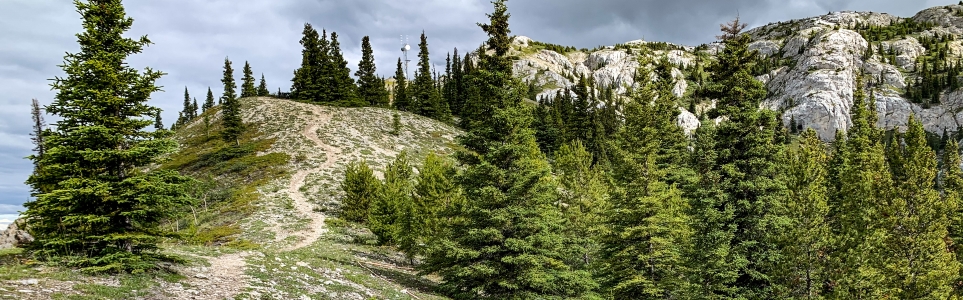
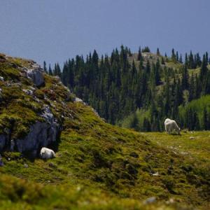
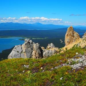
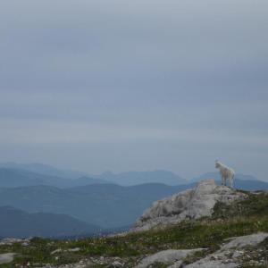
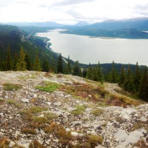
This is a nice day hike an hours drive from Whitehorse that offers a beautiful view of Little Atlin Lake and Atlin Lake. The trail climbs steeply up to a communications tower before continuing into the alpine. The white limestone of this mountain is not what actually gives it its name - it is named after Thomas White, Minister of the Interior from 1887-1888. Watch for mountain goats along the trail. Please refrain from hiking this trail from April 1st to June 15th because the Mountain Goat population uses the area for nursing and raising their kids.
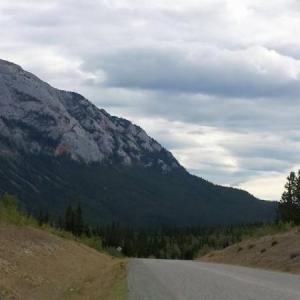
Drive south from Whitehorse on the Alaska Highway towards Jake's Corner (about 80 km from Whitehorse). Turn right at Jake's Corner onto the Tagish Road. Drive for 2 km and turn left to follow the signs to Atlin, BC. Drive for 5.6 km to a road on the left (east) which leads to a gravel pit and generator station. There is a gate at the bottom of the road, park before the gate to the gravel pit.
From the gate, walk up the road and circle around to the left or northwest corner of the gravel pit just before the generator shed. There is a sign at the trees warning hikers not to hike during mountain goat kidding season. Look for the large orange cable that leads into the trees (you'll be following this cable most of the way up).
The path first leads into the trees and soon uphill to some steeper sandy sections. The elevation gain is relentless with some switchbacks along the way. The steeper sections can get slippery and muddy during a rain or after a frost. Hiking poles are a big help on the way up and down the steep sections.
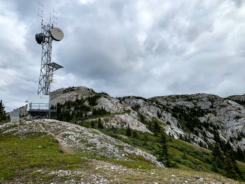
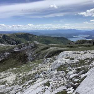
After 2 km of hiking, you will reach a Northwestel radar tower. It is another 1 km from here to the top. The summit is a plateau spotted with white limestone rocks. There is ample opportunity for exploring the range at the top. Add more time if you venture further along the ridge.
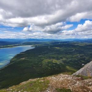
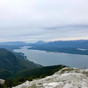
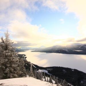
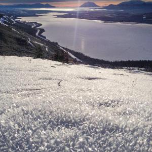
There are spectacular views looking south to Little Atlin Lake, Mount Minto and even further down to the main Atlin Lake.
Follow the same trail as the summer path (occasionally spotted with goat tracks). If the snow is only a few inches deep, hiking poles will be invaluable on the steeper, slippery sections. Add an extra hour to the total time.
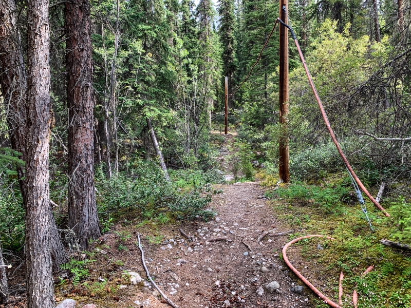
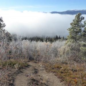
The start of the trail is through the forest.
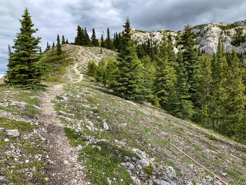
After a steep climb, you exit the forest and continue along the wide ridge.
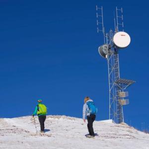
The trail levels out at the communications tower before climbing into the alpine.
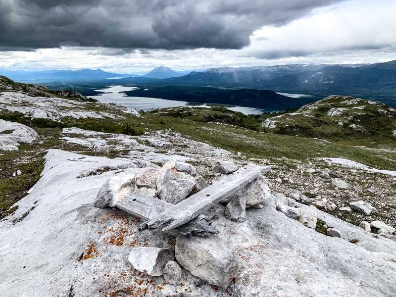
The first cairn up at the top.
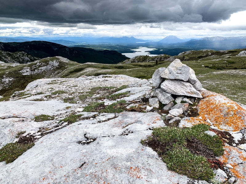
Another cairn, slightly further south, with a view down towards Mount Minto.
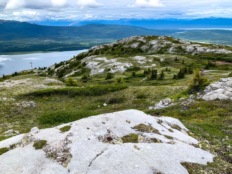
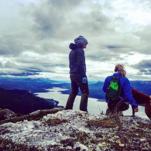
You can wander around the alpine summit of Mount White.
Ascending Mount White.
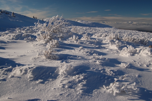
Wind-swept frost at the summit.

The snow can be deeper at the top.
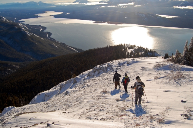
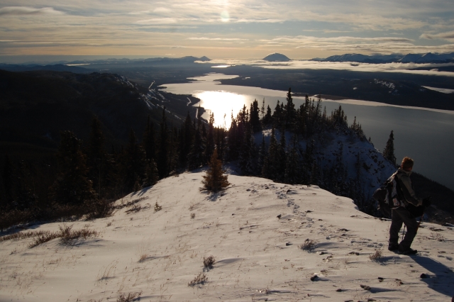
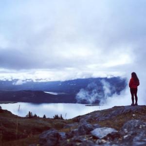
Descending, with a spectacular view of Little Atlin Lake.
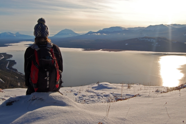
Contemplating the view of Mount Minto.

BWhey July 2, 2026
Great day hike from Whitehorse, didn't start it until ~5pm and descended around 8pm picking up wildflowers along the way! A good ascent pretty quick into the hike - but we expected worse considering the previous comments. Very doable with any amount of breaks spent looking at Mt. Minto and Little Atlin Lake (which is definitely worth a dip in post-hike)!

Frenchie June 23, 2026
Tackled this mountain today and yikes, it’s a tough one! Completed up and back, with a 20 mins lunch at an alpine lookout, in 4 hours.
A very steep trail, the entire way. Today was very dry so the hard-packed earth was slippery and very dusty, in addition to all the loose rock (shale) crumble that blankets much of the upper trail, so good footwear is important (poles were a knee-saver on the way down!).
Wonderful views and the alpine flowers are beautiful in their variety and colour!

Llewelyn June 24, 2025
Hiked this trail on June 22. The sign at the 'left' corner of the quarry is no longer there, but it's fairly easy to find the trail start. Very steep, dry, dusty, and slippery on the way down, poles were very useful. Well worth it for the views and alpine flowers!
Pro tip: the hike does not start at km8 at the 'White Mountain' sign, but at km6 gravel pit :-)
Xiu-Mei October 19, 2020
Hiked on Nov 17. The fresh snow had covered the trail and made it slippery. It took us 5 hours for the trip including explore the summit. We saw the mountain gouts on the summit when we reached to the tower. We had lunch at the helicopter pad and it was quite windy and chill. On our way to the summit, one section was very steep, rocky and slippery. Luckily we were able to come down by the right hand side trail shortly pass the steep trail which we came up with. It was much easier. Hiking pole is definitely valuable. bring water bottle, not water bag- both mine and my hiking friend carried a water bags. Our water got frozen in the tubes outside our backpacks. A good lesson to remember avoid water bag in the winter. It was a very beautiful sunny day and the view was stunning.
Shailyn August 3, 2020
Hiked on August 2nd. Was my second time up there. Just as steep and wonderful as I remember. Certainly worth the little extra effort to go further up the alpine after the towers. Lovely views, windy, at least four other groups up there. No animals sightings. Glad I had my poles with my hip injury as the gravel was quite loose coming down. Took my friend and I about four hours, including lunch at the towers and about 45 min exploring up top.
Cam July 19, 2020
Really enjoyable hike!! Quick elevation gain, amazing views the whole way, beautiful summit.
We saw two mountain goats on the rock face behind the tower. Hiked on a Sunday so we passed at least 5 groups of hikers and their dogs. One hiker carried his paraglider up the mountain and paraglided down. The descent was much harder then the ascent. Some areas are quite slippery/dusty/steep and don’t have a lot of grip. Our hiking poles helped a lot.
Overall his hike was really fun and beautiful, 10/10 recommend.
pamela June 22, 2020
the gravel pit now has gates so most people park below at the road. also the gravel pit has been expanded making it more difficult to find the start of the trail if you are not familiar with it. it is the northwest (not southwest) corner of the gravel pit and right now there is a heap of tree stumps/logs that obscure the sign. go past the pile of trees and then you will see the sign and you drop down a bit before you hit the relentless up. also if you make it to the NWTel tower, you have done most of the climbing. it is only about 80 m more of elevation to gain the summit so don't be discouraged. after the first pitch past the tower, there is some undulating terrain that is very pleasant to stroll around with fabulous views.
David R June 21, 2020
Went here solo. Great little hike outside of Whitehorse. No sign of goats or bears. Its pretty much just straight up
Marie Beattie November 15, 2019
I went hiking on White Mountain last weekend, (November 10) and lost my favourite blueish green toque along the trail, before the helicopter pad. If you happen to be hiking there and find it, please call or email and i'll come get it! Even though its just a toque, its quite special to me! 867 689 8541, mdsbeattie@gmail.com
Melanie Bonin September 12, 2019
It took me a while to find the trail. If you are at the look out, your to far. Its starts right at the gravel pit behind the power station. There is a sign addressed to the Hikers where the path starts.
Its steep almost all the way up. Went on September 12th and didn't see any mountain goats. But amazing view in all directions. If you camp up there, pass the radar tower for wind protected little valley.
Laini June 10, 2019
Oops that shoudl read Northwest. It is right behind the power station ...over the hill... follow the red cable all the way up.
Laini June 9, 2019
Great hike! Entrance is not at White Mountain view point. It is before that...there is a gravel road to the left with a yellow gate across it. Park there. Walk up road. Trail entrance is behind power station on the northeast corner...not southwest.
Liz B August 19, 2018
Hiked Mount White today (Aug 19th). Beautiful views and scenery, we even saw 2 male goats near the summit. This hike is rated as moderate, it is short distance wise but BE WARNED... it's straight up the entire way. It's really dry right now and there are lots of loose gravel/sandy sections that make coming down a bit challenging. I used hiking poles and didn't slip once, my husband had no poles and slipped several times on the way down. All in all an awesome day hike close to Whitehorse!
Emma June 22, 2018
Hiked this one yesterday. The trail was relatively dry and easy to follow with the orange cable running beside it for most of the way. Mosquitos were bad for the first kilometer, but it got fairly windy once out of the trees so didn't have a problem after that. There was a herd of 10-15 mountain goats at the top on the NW side - I kept my distance to try and avoid disturbing them, only stayed at summit for about 15 minutes.
Coming down is slippery with loose rocks and the gradient is pretty rough on the knees, I would probably do it with poles next time.
Round trip time was 2.5 hours.
Hannah May 13, 2018
I did this one last weekend, there was a bit of snow but totally hikeable. It is closed for calving (lambing?) mid May to mid June though.
Jill May 11, 2018
Hey!
Can we hike this ? No concern about the sheep calving?
Anyone know the conditions? Or can you recommend a hike .
Thanks.
Lenore April 29, 2018
A friend and I did this hike today - April 29. Still lots of snow on the trail in the upper half though.
Julien Allard January 9, 2018
Wonderful hike on Monday 7 January, You must have snowshoe at this time of the year! It's steep all way long. I took 3.5 hours to reach the top and less than an hours to go down.
Miriam August 28, 2017
I hiked mount White on Friday August 25 and I lost my all time favourite toque somewhere on the descent. It's just a basic grey cotton toque with a black fleece lining, no brand name or markings. I would be ever so grateful if someone finds it if they would please get ahold of me - 334 4576
Sharon July 9, 2017
It was extremely steep the entire way up, much more challenging than I thought it would be. I would advise that you take walking poles on the way down as I slipped once. It was scenic and a nice butt kicking, reminding me of the grouse grind in Vancouver.
Matthew June 21, 2017
Don't know how you can rate this trail "Moderate". It is a very steep climb almost the whole way with no switchbacks. And coming back down is almost as difficult because of the grade and the slippery surface. The trail was never designed for hikers but to access the radio tower. The hike was worth it but I think you should describe it more accurately.
Dwight Gayle May 9, 2017
Nice short trail that takes about 2hrs round trip on foot.there's a few large trees at the base of the mountain, But except that part its ready to Bike for the 2017 season!!!
Pat & Nikola May 6, 2017
It's a decent incline right of the get go and we were glad to have hiking shoes as some of the scree is slipery. The trail was dry all the way up to the tower , afterwards there was various patched of snow to dance around.The peak has absolutly amazing views of Marsh lake , little atlin and even the tip of Atlin lake . We plan on coming back when later in the season to keep exploring the plateau and camp up there .
Jason Wright April 18, 2017
Hiked Mt. White on Saturday (15 April). Trail has some small sections of compacted snow in the shady areas, but the majority of the trail up to and past the antenna is clear. Spotted a pair of bald eagles soaring in the thermals and a merlin too.
Jo November 6, 2016
Hiked to Mt White on Sun Nov 6. Day started out grey and snowy and kept improving all day. Really windy and cold on the summit though. We were glad we brought down, tuques and mittens. Thanks to whoever hiked this trail yesterday, it made the summit plateau snow easier (up to a foot of snow). Great view of little Atlin, goat tracks and interesting cloud formation all day. We came down under a warm sun and bluebird skies. Met two parties making their way up (2 & 4) so trail to the top should be even better in the next few days. Good fall hike option!
Shailyn Drukis October 10, 2016
Hiked up Mount White with some friends today.
Took the usual route and continued on past the helicopter pad to the summit. It was a wonderful day for hiking. At first we had to walk through a frosty cloud that blanketed the trees with a lovely layer of frost. Nice and sunny above the cloud. No wildlife sightings, and some snowy/icy patches up top. Took us about four hours with a lunch break and tons of photos along the way.
Miriam September 2, 2016
Went up to summit solo the other day. Trail head is easy to find and follow. Ther were some sticks leaning on the sign to hikers, in retrospect, I should have grabbed one. Coming down is hard on the knees. There is a faded red cable along the ground from the generator that goes up to the tower so it's pretty clear where you're going. It was a cool misty fall day when I went but this trail gets steep right away and my heart was thumping and calves were burning pretty quick. Doesn't take long to start getting a nice view.
Once at the top I explored up there a bit, saw 9 mountain goats! I kept my distance but it was pretty neat to watch them for a bit. Saw what I believe to be some old signs of a bear digging up roots.
On the way down I munched on some berries (not sure what kind, they were blue but not blueberries).
A couple of grouse were in my path on two separate occasions, impressive how camouflaged they are in this setting. What I believe to be 4 northern hawk owls made an appearance, swooping around, chasing each other in circles above me making little chirping noises. Was pretty spectacular. Later on a flock of over 100 migrating birds flew over. There were many little flitting around in the trees as well, I could only identify white crown sparrow, yellow warbler and was surprised to see a couple robins!
I've been wanting to do this hike for a while and I'm glad I picked a misty fall morning. Was a great day
Matt French July 6, 2016
July 5, 2016.
Climbed to the radio tower. Took roughly 1:45 to get there; including stops for pics of the surrounding area. Hot, sunny day with little in the way for a breeze; even on the exposed ridges. Bring lots of water on such days!
Trail is well established and following the cable over the rocky sections kept route finding quite easy. Very steep in sections and the dry dust of the trail, mixed with the loose rock made for many close spills on the way down. Would recommend hiking poles on descent, not so much for leg support, but rather balance and speed control.
First solo hike since arriving in the Yukon last September and would recommend this short hike as a good introduction to the peaks in the Whitehorse area.
Kirsten July 2, 2016
July 2, 2016
Awesome hike, great views, tired out puppy. A winning hike all around. Easy to find,close to whitehorse. Great quick hike.
Loralee May 16, 2016
I hoped to do the trail this weekend (May Long) but realized it's advised not to. Is there another hike in the area that anyone would suggest?
H. August 16, 2015
A steep but rewarding hike. Great views and well worn trail. Lots of loose rocks and dirt on some of the trail, which makes for slippery footing on the way down. Leaves are starting to turn up top - lots of yellow coming in.
Judy July 15, 2015
My daughter and I did this hike on July 7th, 2015. The trail head is very easy to find. We hiked on a very warm day so my 2 litres of water was required. The trail is quite steep and my calves were burning on the way up but I kept moving and it was worth it! The views on top were fabulous and there were lots of goats to watch. We ended up going to the highest point and were able to sit and have lunch without much of a wind.
I knew the way down would be even more challenging and I highly recommend bringing walking poles. I beieve thats what saved my knees.
Great hike, Great Workout!
Mike February 20, 2015
Snowshoed up partway, there isn't a trail broken the whole way up any more.
We found a lens hood for an SLR-style lens. If you lost one on this trail before Feb 20, 2015 send me an email and you can come pick it up in Whitehorse. mike@mikeotto.ca
Marko November 17, 2014
We had a great hike up Mount White this weekend. The snow was only a few inches deep in most places, so hiking boots worked just fine. The surface hoar frost crystals were huge!
Victoria August 25, 2014
This trail is pretty steep! Going up there's some places you have to climb with your hands but the rocks are small enough that's it's fairly easy. On the way down, it can get slippery and I had to catch myself a few times - wouldn't recomend doing this hike in the rain. After the radio tower the hike gets a lot easier. You'll notice a small cave to the right of the large mountain but no trail leads to it, my sister and I were hoping to get to it to explore but it was getting late and ha to go home. Once on the top, small rolling hills seem to go on forever, it's very fun to explore.
If doing this hike in the fall, bring your camera! The low ground covary turns a beautiful red as do the mountains beside and can be very beautiful!
When we reached the top, we saw no mountain goats or even much traces of them ever being there, except some tracks on the ground.
There are a lot of good places on the top to camp it seems, it would be easy to start a fire and the ground is soft and there are some flat parts.
Neil Graham August 28, 2012
My wife, two daughters and I hiked up White Mountain. What a steep trail, however, the fantastic rambling around available at the top is worth the effort. We didn't see any goats but collected lots of wool off the bushes.
Jen April 9, 2012
Hiked to the radar tower yesterday. This is a wonderful shoulder season hike--although there was some snow on the trail, it was packed enough not to need snowshoes. About 50% of the trail didn't have snow; it was great to walk on soil again. Gaitors could be helpful--it was slushy and muddy coming down in the afternoon.
Yukon Hiking August 9, 2011
Thanks Jeff, we've had many people comment on the name of this mountain. We decided to stick with the official name, but you are right, it is more often referred to as White Mountain. The wooden sign at the base of the mountain reads White Mountain as well.
Jeff Fisher August 9, 2011
I think the name of this mountain is more commonly referred to as White Mountain.
