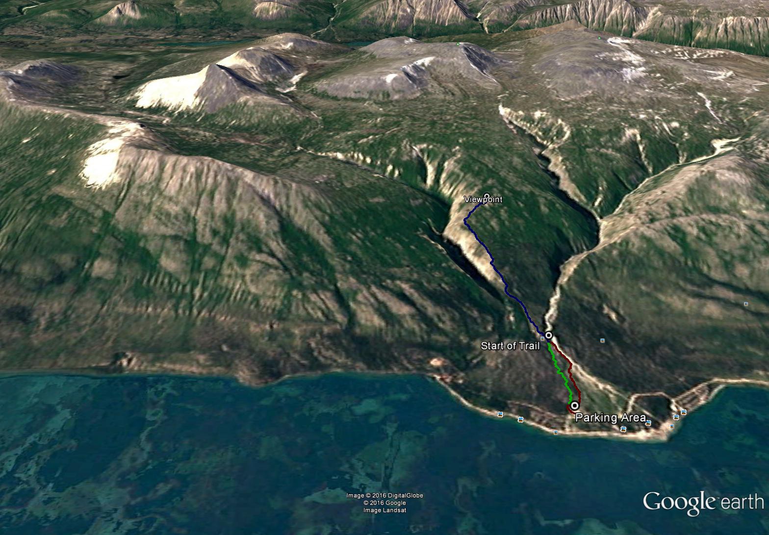
Total Distance: 6 km
Return Time: 2.5 hours
Elevation Gain: 529 m
Difficulty: Moderate
Region: Whitehorse
Traditional Territory: CAFN
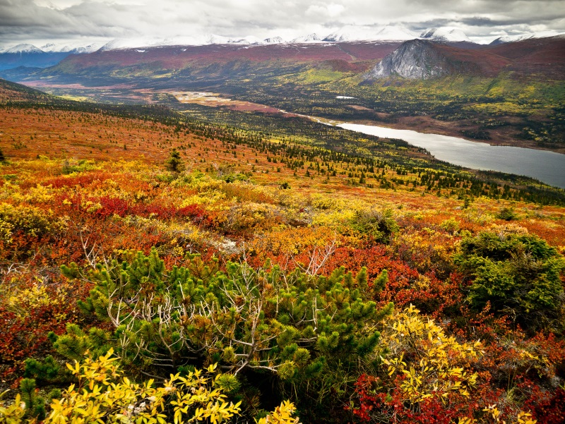
A varied and beautiful trail up into the alpine with gorgeous views of Kusawa Lake and the surrounding mountains. This trail is south of the well-known Kusawa Ridge Trail, and provides a different perspective of the area. This is an especially beautiful hike in the fall and there are many opportunities from the viewpoint to continue farther into the alpine up any of the rocky ridges or towards Jo Jo Lake.
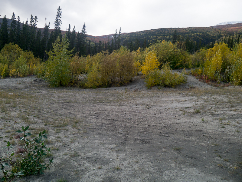
Drive about 65 km north of Whitehorse on the Alaska Highway until you reach signs indicating Kusawa Lake campground on the left side of the highway. Follow this dirt road past the Takhini River campground to the Kusawa Lake campground (23 km off the highway). Drive past the campground and then past a bridge, for another 800 m. There is a pullout on the right, in a clearing for parking.
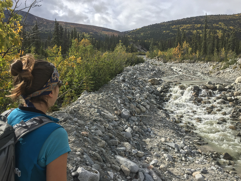
Be warned, from the parking area there is no defined trail for the first 900 m. There are several options to get to the trail from the parking area, but they all require route-finding skills in order to get through the forest towards the base of the mountain slope to the west. If you head slightly northwest you will reach a creek which you can boulder hop alongside (if the water is not too high) heading west (there is no need to cross the creek). Note this creek is the same creek you follow for the Kusawa Ridge Trail (just on the other side). Before the creek reaches a canyon and heads more northwest, a well-defined trail can be picked up on a small narrow ridge to the left.
Alternatively, you can also reach the start of the trail from the parking area by picking your way through the floodplain forest of willow and poplar or the adjacent spruce forest on the left (southeast). There are many animal trails throughout this area.
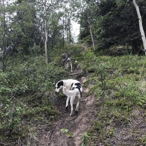
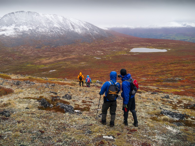
Once you reach the actual trail, it heads quite steeply uphill through first spruce and then aspen forests. Thankfully there are many little viewpoints along the trail where you can take a quick break and catch your breath while enjoying the views of Kusawa Lake. The trail begins to follow above another creek drainage to the southwest.
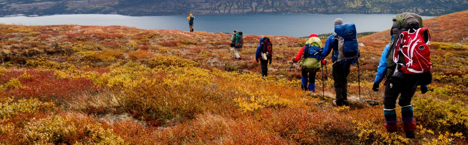
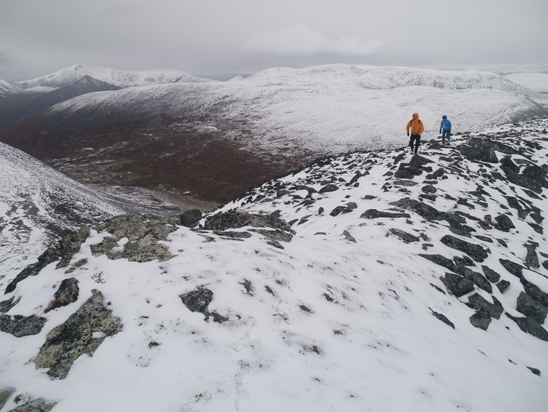
As you gain elevation the aspen trees become shorter and more stunted, until eventually disappearing altogether once you reach the alpine. The trail continues over rock and lichen and becomes less defined. Enjoy the views from the open alpine and head back down at your leisure.
EXTENDED HIKE OPTIONS
Note if you want a longer hike, there are some small ridges and a small alpine lake worth exploring to the southwest of the viewpoint. If you continue further west from there, you would eventually get a view of Jo Jo Lake. These options would add another 12-20 km (return) to the distance listed for this hike. There are many options for backcountry camping in the area if you want to make this an extended trip.
The trailhead parking area.
Hiking along the creek.
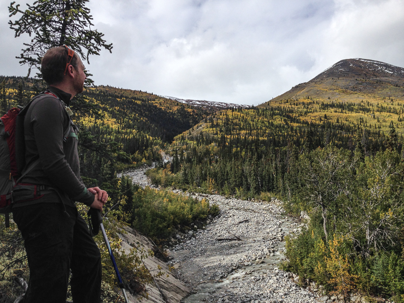
Looking at the view of Kusawa Ridge across the creek.
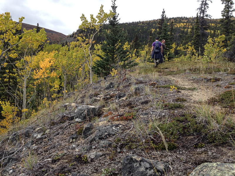
Following the trail up through the trees.

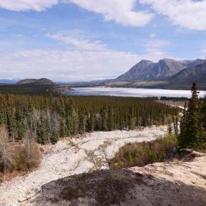
Taking a quick break to enjoy the views down Kusawa Lake.

Once in the open alpine you can enjoy the views of the surrounding mountains and Kusawa Lake.
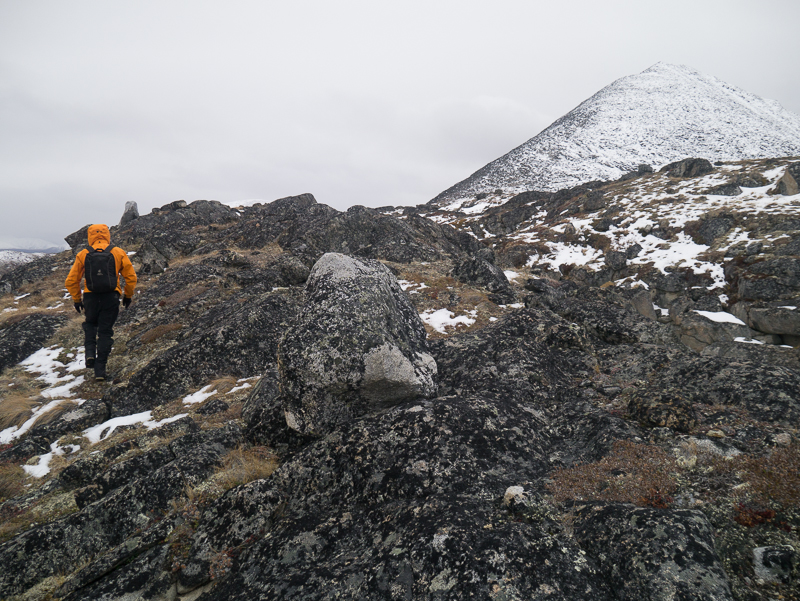
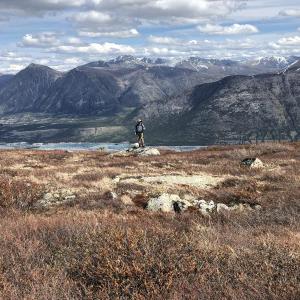
Continuing further into the alpine, there are some small rocky peaks that you can explore.
Hiking along one of the rocky ridges to a peak.
Approaching the small alpine lake on the plateau near Jo Jo Lake.
Catching a glimpse of the south end of Jo Jo Lake.
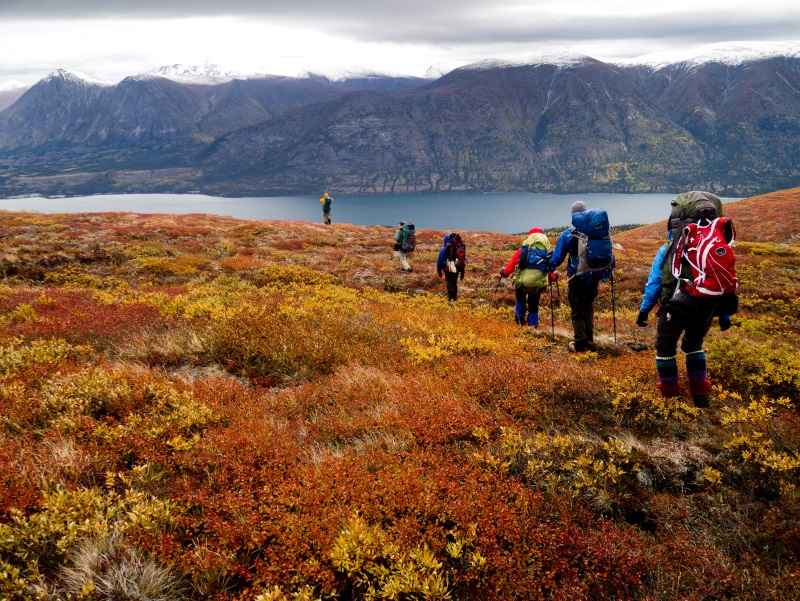
Hiking back over to Kusawa Lake.
Bonnie May 26, 2026
May 23, 2026- Beautiful hike up the ridge today!
Ree November 23, 2025
Broke trail up to the treeline today. The snow isn't too deep yet and there's even less in the alpine. I would've continued but was running out of daylight. With the inversion it was a good 10 degrees warmer at the top of the ridge than down in the valley, and sunnier. Makes for a gorgeous day and a good workout.
@Sasko I've had that issue with my Garmin watch too, it sometimes only recognizes one segment. The actual file posted on here is fine - I've loaded it into Avenza on my phone with no issues.
Yukon Hiking June 6, 2025
@Saska --> Just tested the GPS download and the GPS file does have all the necessary trails and waypoints, including the forest route, creek route and main trail. There must have been a problem connecting to your watch.
Sasko June 1, 2025
Hiked Kujo Ridge on June 1, 2025. It's a nice casual hike, particularly this time of year. No snow made for good hiking, but we didn't end up summitting to the final viewpoint. Roughly 2.5km (340m EG) into the trail, we ran into 2 adult female thinhorn sheeps and their 2 lambs crossing the trail. We gave them a wide berth to cross and after they finished, we turned around and headed back to the parking lot. I'd probably recommend staying off of this hike until the June 15th lambing season is complete.
The first flag in the main parking lot was placed in the middle between the forest access and creek access. We ended up taking the creek access and bushwhacking until getting to the merger between the creek access and forest access. When we descended, we took the forest access down and found some of the flagging close to the parking lot. We moved the flagging in the parking lot so it was closest to where the forest access entrance, as intended. The forest access is a much better path for this hike.
@YukonHiking when I downloaded the GPS tracks for this hike and uploaded them to my Garmin Connect, I was only able to get the Creek Access section on my Garmin Watch. Could you re-add the trail download for this hike for future users?
Keith Cruz October 1, 2023
Did this hike September 23, 2023. Great hike! I didn't go all the way up the summit as about 3/4 up there's a nice plateau to take pictures from. I unfortunately lost my car keys somewhere in this hike, so if you see it, please email me at keith.cruz2585@gmail.com. its a Subaru key. Thanks!
Ricki September 26, 2022
Did this hike this weekend, Parked in the sandy parking lot and stuck to the left there was a visible trail right away. Soon after starting it there is a huge pile of boulders to the right to let you know you are on track. Once we hit the alpine, there was no visible trail at all, we explored but bush whacking was needed for this and would definitely recommend putting some trail markers when exploring as we got off track and had to bushwhack through a lot of brush to find it again. Gave an extra little workout. Views were nice though.
Laura September 7, 2020
Did this hike September 5, 2020. Started from back left corner of sandy parking lot by blue flood warning sign, after bridge between campgrounds. No flagging tape aside from small piece at trailhead in back left corner of parking lot but trail very well used and easy to follow.
Denise May 15, 2020
This is a really beautiful hike! Did it on May 12th, all clear, no snow.
For those who are worried about the "first 900m of bushwacking/ following the creek": You don't need to worry any more! There is a well flagged trail to follow. Drive past the bridge with your vehicle (there is a bleu sign right by the parking) and continue down the road towards the campground. There will be a large, sandy parking area to your right (there is a ble sign (the trailhead is not immediately after the bridge!). At the back of the parking area towards the left, you will the first tape in the trees. The trail will be flagged frequently for the first km or so. Sometimes, the trail is not so obvious but you can just follow the tape, this is (in my mind) the best and easiest way through the first section. Afterwards, the trail becomes steeper and steeper, leading you right into the alpine. The is room for more exploration up top, but this will require a good deal of bushwacking.
Great hike!
CG September 16, 2019
TO ACCESS TRAIL: There are multiple "trail entrance" looking spots from the parking pull out. Key is to access the left-most "trail-head looking" entrance. We tried the middle one and couldn't find the trail, until we hit the creek...
A super enjoyable hike, very moderate and VERY beautiful!
Shailyn May 20, 2019
Hiked this yesterday. New trail for me. I really enjoyed it. We were able to find the start of the trail through the forest pretty well. Seems like someone put out some flagging tape, which really helped. That quickly disappeared, but was useful. We went up to the viewpoint, thinking that was only part way up the trail and ended up bushwhacking through a ton of willows to get up to the alpine. We were hoping to see the alpine lake but couldn’t find it. The wildflowers were starting to come out and the alpine spring melt pools were beautiful. Old bear scat and some ungulate scat (sheep?). On our way down we found a game trail for a bit, making the journey back to the trail a little easier, but that also quickly turned to more willow bushwhacking until we got back to the trail. We managed 10km and 830m of elevation gain. Lovely day and lovely trail. No snow on the trail. Only some piles left higher up.

Kyle September 15, 2018
Great hike, took 2 hours to the summit.
Lots of space to go explore at the summit.
Fall colours are all out at the moment.
After passing kusawa campground there is a bridge, go over it and right after to the right theres a round about type parking space. Park here and theres several trails that lead you up the creek to the trail and are marked with red tags. If you miss the round about parking spot you'll get to the second part of the kusawa campground and a private lot, if you see this than you've gone too far.
If you follow this correct trail then there is no bushwhacking whatsoever.
If ever lost you can just follow the creek up the mountain which is very loud with heavy water flow coming down.
Natasha June 3, 2018
LOST PHONE ON KUJO RIDGE! Hi, we hiked the ridge today and a phone slipped out of a backpack. If anyone finds and Iphone on the trail. Please called 867-335-4409. Thanks!
Also - it was a great hike. 5 Stars.
Jim August 9, 2017
Lost a pair of binos up there, if you find a pair and want to return them give me a ring at 689 2555. Thanks :)
Stacie July 6, 2017
Great, easy hike! Kusawa ridge was too busy for our liking so we went to Kujo ridge. No people. A bit of bushwhacking at first, but we were able to find a semi-decent route to the trailhead on the way up. It skirted to the left of the big rocky section. But on the way back it was bushwhacking 101. It's not super obvious but it wasn't long before we saw the parking lot either. There's a bunch of game trails, so those can be confusing so don't follow to far to the left. The ridge trail is towards the creek, on the right.
Great trail and lots of opportunity to explore at the top if it wasn't enough for you!