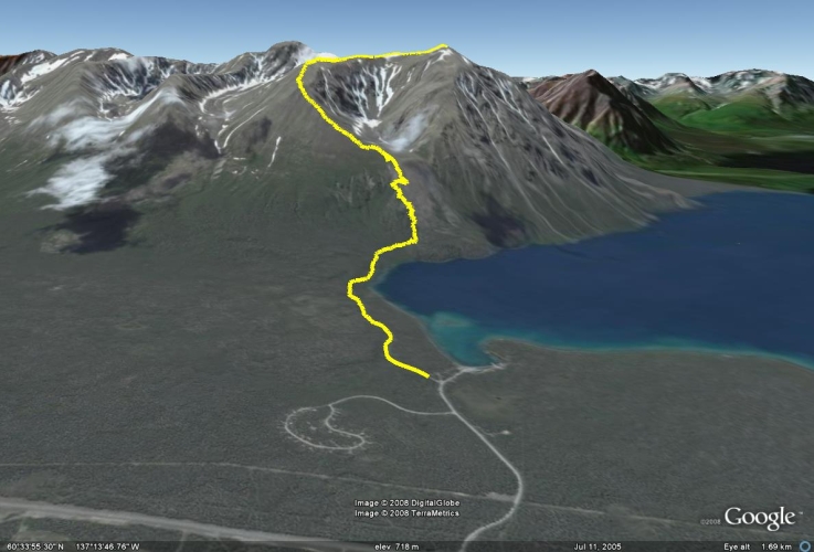
Total Distance: 15 km
Return Time: 8 hours
Elevation Gain: 1250 m
Difficulty: Difficult
Region: Kluane
Traditional Territory: CAFN
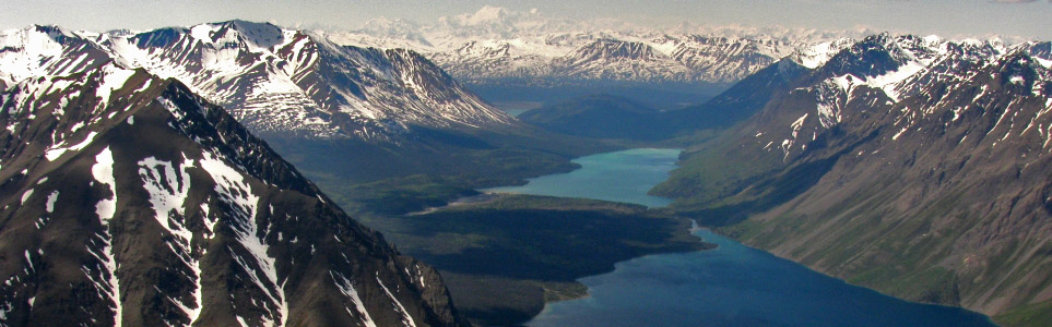
The King's Throne is truly a majestic site when viewed from the shores of Kathleen Lake. It is one of the more popular day hikes in Kluane National Park, with breathtaking views of the surrounding valleys and Kathleen Lake below. The route described goes to the summit, though many people opt to save their knees and stop once they reach the seat of the throne (at the top of the rock glacier, about two thirds up).
Drive south from Haines Junction on the Haines Road for 32 km. Turn right at the Parks Canada Kathleen Lake Campground sign. Stay on the main road that leads towards Kathleen Lake (rather than taking the left eventually up to the campground), and look for a sign that says Cottonwood Trail / King's Throne Trail. Park where the sign indicates. Here you will find the old mining road which is the trailhead.
From the parking lot, follow the old mining road through the forest and eventually alongside Kathleen Lake. You will reach a fork in the road with a log sign post which indicates to go left for King's Throne/Cottonwood Trail or right for Kathleen Lake. The sign post may be knocked down. If in doubt, always stay to the left on the road. Take the left and continue until you reach the second fork with another log signpost which indicates to go left for King's Throne or right for the Cottonwood Trail. Take the left path which immediately begins to climb steadily upwards.
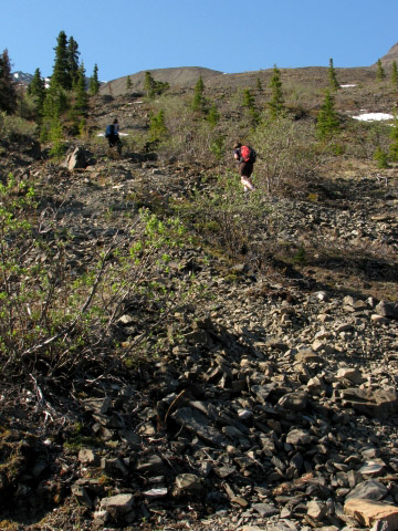
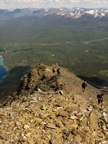
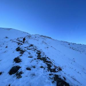
After a steady climb in the trees, you will reach the treeline and will be following the rest of the path through loose rocks. Here you will get your first view of Kathleen Lake and the surrounding valley. The path switchbacks up the rock glacier and should be clearly visible if there is no snow on the trail.
You will reach an obvious plateau in the 'seat' of the King's Throne with an amphitheater of rocky ridges surrounding you. This is a popular lunch stop with an amazing view, and is the turn around point if you are not interested in climbing along the steep ridge to the summit or are looking for a shorter hike.
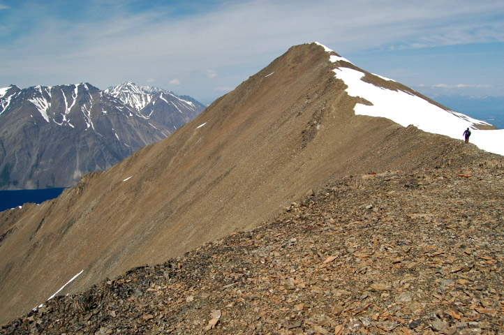
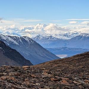
If you decide to continue up towards the summit, the trail becomes more difficult, but is well worth the effort for the extra view of the other side of the mountain. Facing the mountain, you will be taking the left ridge, so continue along the trail and follow it up the steep climb to the top of the ridge. This left ridge will eventually lead to the summit on the right, so don't be tempted to take a short cut and climb the ridge on the right - it's even more steep with loose rocks.
The climb is steep but you're rewarded constantly with new views. You will soon get a view of Dezadeash Lake to your left. The trail should remain clearly visible except in some rocky scree areas where the trail is not always easy to see.
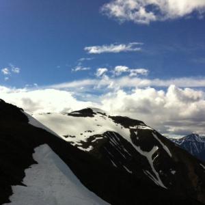
At the top of the ridge will be a plateau where you get a view of some of the mountains adjacent to King's Throne. However, you also get a taste of the brutal winds that can knock you straight off your feet, so you may decide to take a few photos and continue along the ridge right away.
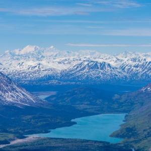
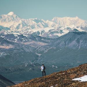
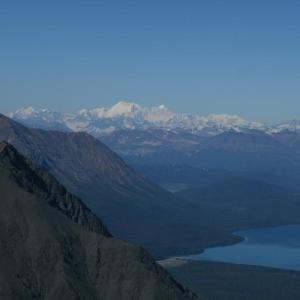
After another steady climb you will finally be rewarded with a magnificent view behind the mountain. Carefully follow the thin ridge towards the summit of the King's Throne. Valleys, rivers, lakes, and mountains seem to continue without end. On a clear day you can see the large massif of Mount Alverstone, Mount Hubbard, and Mount Kennedy from here. Return the way you came up.
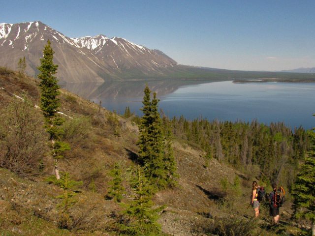
A view of Kathleen Lake opens up as soon as you get out of the trees.
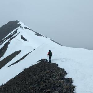
Hiking up the switchback trail on the rock glacier to the 'throne'.
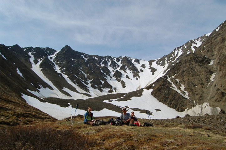
The 'throne' is a perfect spot for lunch. This is also a popular turnaround point.

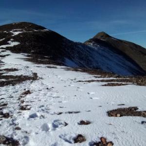
Hiking up the left ridge.
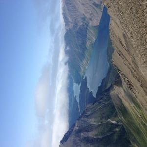
The left ridge starts to become rockier and more narrow, but the trail is easy to follow.

The large missive of Mount Alverstone, Mount Hubbard, and Mount Kennedy on the Alaska/Yukon border.
At the top of the left ridge, cross over and hike to the right ridge and the summit.
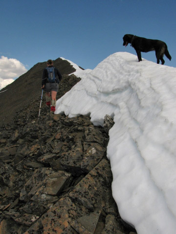
The route to the summit is often half covered in snow. It is usually safer and easier to walk on the rocks.
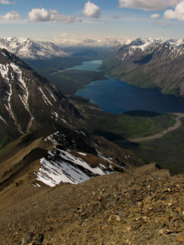
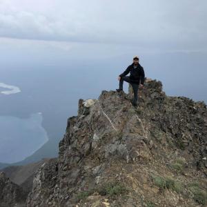
The view from the summit into the depths of Kluane National Park. One of the most amazing views and a great reward at the summit of the King's Throne.
RD September 9, 2025
Awesome hike. A few steep sections that are soooo much easier with poles. Views were amazing in all directions. Definitely pick a sunny day for the hike. And don't forget to check out Kathleen Lake Day Use area. Beautiful spot as well.

AB July 17, 2025
Hiked King's Throne to the summit on July 16, 2025. Clear trail all the way, with snow patches along the ridge, but none that interfered with traversing the ridge or following the trail. The summit view is definitely worth the extra time and effort to get there! We had hiking poles we used for the way down, as it was very hard on the knees when so steep, and loose ground/rock; we passed a handful of other hikers going down that did not have poles, and wished they did....so I recommend bringing some!

Emily June 7, 2025
Made it up to the ridge and approx 500m from the peak. The peak was snow covered and you couldn't see the cairn. Winds between 65-70k but doable for me and my partner. Climb to ridge had one section of snow patch. We didn't use hiking poles. I had small size crampons and my partner only used them for the snow section. Hike was great!

David May 10, 2025
We did this hike on the 10th May 2025. The trail has snow patches until the rock glacier, which was straight forward. From there to the throne is snow covered. This part was tricky and we would have needed more gear to do it. Went a bit further from the bench and had to turn back and then struggle on our way back to it. The view from the bench was really nice.
David May 10, 2025
We did this hike on the 9th May 2025. The trail is snow covered where snowshoes are needed. The views and atmosphere was superb. Found many scatters and footprints from many different animals.
Udo Kellner March 17, 2024
Great hike with great views. Still lots of snow at the top. Were there in June 2023 and even saw a porcupine. Here is my video with porcupine, if you like it:
https://youtu.be/_5VxYDXEN7o
Greetings from Germany Udo
BC September 5, 2023
Awesome hike! I did this on Sunday and really liked it. Having moved to Yukon from the PNW I have been shocked at difficulty ratings here - "moderate" hikes are typically what I would consider difficult, so I wasn't sure what to expect with this one and wasn't sure that I would finish it. I have to say, it was easier than I'd anticipated, in line with what I'm used to for 4k elevation gain and a "difficult" rating. There was some snow which made the ascent challenging, but luckily had mostly melted by the time I descended. We saw a huge porcupine on the way up, so watch your dogs!
Shailyn June 12, 2023
Hiked to the bowl (and about 250M elevation above) on June 4th. Was a couple snow patches on the switchback scree, but all were avoidable with alternate established paths. No bear signs, but there is currently an active bear warning for the forested stretch (and the beginning of the Cottonwood). Some friends summited and said the snowpatch on the ridge was sketchy, We would see some snow falling down from the ridge while we were in the bowl.
CM October 9, 2022
Did this on Oct 8th during an unusually warm spell this October. Zero snow on the hike up the east ridge, excellent traction since the ground was still damp from melting of recent dustings. Visibility from the top was superb, the Hubbard massif was awesome. No snow at all until the recent (but melting) drifts on the leeward side of the summit ridge that are still small. That'll change in a few days...
KH June 25, 2022
I did this with my 14 year old son - We went to the summit on June 25. There was a bit of snow along the final ridge but was very doable. Amazing hike and well worth the effort. It took us 7 hours - glad we started early and got down before the heat. Hiking poles are a must if you want to go to the summit.
JWY May 14, 2022
We attempted the Kathleen Lake/King's Throne hike on May 11th. We did not have snowshoes, and there was enough snow to make the hiking quite difficult. We ultimately made it the 1.7km to Kathleen Lake, along with 1km up the King's Throne trail, before turning around. Still gorgeous though!
EG April 16, 2022
Attempted to make it up King's Throne on April 15 but were only able to make it about 6 km in (we knew we wouldn't make it to the top as no one had done it lately). My hiking partner had snowshoes but I didn't so it was a bit more of a challenge but still good fun (sugar snow up to my waist in some parts). We turned around when it started to be too steep and too difficult for myself to keep going. We also didn't feel confident enough to read the terrain for possible avalanches as the weather was warming up. Snowshoes/poles or crampons/spikes to go up the steepest section and a knowledge of the mountain are a must. Amazing views of Kathleen Lake once you get past the tree line.
Rachel March 30, 2022
Took a trip with 3 girlfriends out to kings throne in March. The hike was gorgeous and challenging. Another hiker had gone out before us (maybe a day or two earlier) so there was a path already paved. snow shoes and walking sticks (or ski poles) are absolutely recommended for this time of year. no sign of animals.
we only made it up 3/4 to kings throne because the path completely disappeared in the snow. there were places where if you stepped snow was up to thigh. so tread lightly and slowly!
DRM October 30, 2021
We did this hike on October 24, 2021 in ideal conditions (firm snow, cool and not too hot). The trail was quite icy starting from the parking lot and snow packed once the elevation climbs. We followed foot steps in the snow about 300m before the ‘throne’ where we stopped because we didn’t want to break trail (3.95km from the parking lot based on my Apple Watch). Microspikes/crampons and trekking poles are an absolute must given the steep last ~600m before the ‘throne’. It was entirely fine up until where we stopped, however can definitely see it getting a bit dicey with snow melt/refreezing or with heavy snowfall. Otherwise a beautiful hike (and thank you to whoever left the staff/walking stick for my friend at the trail head)!
Mary h August 4, 2021
We were on kings throne Friday July 30. I got a great photo of a couple on the summit ridge I would like to share with them. If you read this and were wearing a canada buff (male) nd had long blond hair (female) please send me your contact info and I'll send you the photo
Q November 5, 2020
Does anyone know if it would be advisable to do this hike in mid-December or would that be unsafe?
WL October 5, 2020
Did the hike on October 3, 2020.
I got there at 8:30 am and made it to the peak around 11:30 am. Took some photos at the top (very, very windy) and made it down to the parking lot around 2:30 pm. There were some snow patches at the top, but didn't find it too dangerous or slippery.
I only ran into two groups that day, so bear spray is highly recommended! Painful hike, but totally worth it! Dress warm!

Liz B September 8, 2020
We hiked to the summit of Kings Throne on Sunday of the long weekend (September 6), there was not a cloud in the sky and no wind at all, a rare bluebird day in Kluane! According to out GPS, our distance was 14.6kms and our elevation gain was 1344m. To the top of the bowl was a 550m elevation gain, so if you're planning on going to the summit, you still have close to 800 vertical meters to climb!
The trail is very well defined and easy to follow, both up to the bowl and up to the summit. Yes this trail has a lot of loose rocks and it does get steep in spots along the ridge but in my opinion it's no steeper than other hikes like Nares, Caribou, Tutshi Ridge, etc, it's just a bit longer. My knees aren't great so I used poles on the way up and the way down. Even if you have good knees I would still recommend them for the way down.
Our total hiking time was just over 7 hours. We started the hike just before 9am, took lots of photo breaks and spent around 30 minutes having lunch at the summit. We were the first ones up the mountain and ended up passing over 30 people on our way down.
We saw a handful of ground squirrels, one pika and a mom and baby goat. There were a few signs of bear (scat) on the trail through the woods but didn't see any bears, not surprising with the amount of people who were hiking that day.
Great hike with incredible views of Kluane!
Terri & Donovan Dewis August 1, 2020
Great trail and workout! Bring walking poles to save knees and ankles as schale is loose at times. Harder on joints going down mountain than going up, but poles would have helped. We hikes past King's Throne about 1.5 km up that mountain to the Mountain Summit. Didn't end up completing the Mountain Trail as Husky was too hot and we weren't prepared for another 4 hour hike in that heat. Spectacular view of Kathleen Lake and the surrounding Kluane region! Highly recommended. Bring plenty of water and lunch.
Terri August 1, 2020
July 31, 2020. Hike to King's Throne and about 1.5 km up the escarpment towards the mountain summit. Day was hot and dog was tired so couldn't conquer the summit that day. Total hike about 6 hours return. Bring walking poles as lots of loose schale. Not recommended for those with ankle an/or knee issues especially when going down the mountain side. Overall, great day, great hike! Recommended. Bring plenty of fluids and lunch.
Leigh July 5, 2020
Hiked to the summit on July 3rd 2020, we saw a lynx on the trail close to the seat. The weather was hot and there was little wind at the summit. Most of the snow is all gone, there’s a bit of snow just right before the summit but other than that it’s a perfect time to hike this beautiful trail! No bears spotted.
Corinne July 4, 2020
It was sunny with almost no wind, July 3 , 2020. The mosquitoes were awful, but only for about an hour, once we got out of the trees they were pretty much gone. We had bug nets which made things more comfortable, We surprised a lynx coming down from the Basin on a far right trail, he might have been taking a nap we think because he was pretty close, but ran away as soon as he saw us, A beautiful hike.
Erin June 11, 2020
Hiked Kings Throne on June 10th. Beautiful day, minimal wind until the summit. There was some snow at the end, otherwise the trail was clear and in great shape. Lots of mosquitoes.
@whereisuzie September 29, 2019
Summited Kings Throne Oct 28. Its a gorgous time of year up there but the trail is a bit slippery, a fair bit of snow accumulating, knee deep in some places. Id recommend crampons for anyone heading up next weekend.
m+d September 15, 2019
Hiked to the summit yesterday. Outstanding views into the ice field. No snow on the route yet. Bear scat on the approach below tree line. Not too cold or windy on the ridges, but thermal layers, a shell, glove and toque recommended nonetheless.
Scott Chadwick August 19, 2019
August 18th 2019, base temperature 12c, winds gusting to 15k, upper alpine temperature decreased dramatically; wind gusting to 40k, almost "winter like" conditions at the summit, thermal layer under shell, mandatory.
Sandrine et Sevan August 13, 2019
Amazing trail, well maintained, the farther you go, the better the view after tree line. Busy trail, no bear signs, few mosquitoes. Worth walking more after king's throne for the views:)
Natalia July 28, 2019
If you don't like scree, you might not enjoy this hike. Going up is easier than coming down. Be prepared for the high and strong winds. I turned back 2/3 before reaching the summit. Thick clouds and light rain on and off discouraged me from finishing the trail. No bears were spotted. Poles would have been handy in some parts.
Ray July 23, 2019
We dethroned the King yesterday! The view as is described from above. It is truly majestic! The view from the bowl does not get better up to the summit but it can be made as your personal record like mine. We were fortunate enough to see a double rainbow under us and be in a cloud. No sightings of bears but chipmunks. It took us close to 10 hours the entire hike due to the heavy rain coming down. Happy hiking!
Taibhsearachd June 21, 2019
Hiked as far as the 'bowl' yesterday. The weather was perfect and there were lots of people on the trail, so no sign of bears. This was a really challenging hike for me but so glad I did it. The views, even from the bowl, were pretty special.
Cata May 22, 2019
Hike it today with the dog(may 22), beauty day and just one other person :)
Beautiful as always
Lauren March 6, 2019
Anyone know if this route is possible in March?
Angelo Nonog October 3, 2018
As rated, it is a difficult climb and descent, especially if you have some knee issues.
Snow patches up the ridge leading to the peak. Magnificent views along the way. Celebrated a personal milestone up there
Greg September 28, 2018
Trail is still in fine form! Snow is mild at best.
Derek Kyostia September 12, 2018
Trail was clear and dry. Evidence of a light dusting along the ridge but otherwise great trail conditions. Apparent trail erosion in spots where people are cutting the corners on switchbacks. Beauitful weather and incredible autumn colours! Perhaps the quintessential Kluane hike. A solid workout with infinite rewards!
Theresa Lenkart August 12, 2018
I did the Kings Throne summit yesterday and it was amazing. I sadly left a womans black jacket at the lower bowl. If by chance someone picked it up on their decent, I would appreciate it if you have me a shout at 306-730-8414.
Kamil Szybalski August 7, 2018
What a trail! Here's our trip report - http://hktreks.com/index.php/2018/08/08/trip-report-kings-throne-yukon-alaska-road-trip/
Kyle July 23, 2018
Went up King's Throne July 20th.
A few snow patches at the summit at 27 degrees outside to cool yourself off. The trail is at its nicest this time of year, green grass and colourful flowers.
My GPS told me it was 19k for round trip.
Many people on the trail, well used. Better to use side trails I found on the descent than the trail because the trail is so well used that its basically steep dust and very hard to grip with your boots. Many people including myself were falling over.
The view is incredible at the final destination and worth every step, full view of Kathleen lake in every direction.
I ran into a Grizzly on my descent. He was in the ''bowl area'', which is exactly 5km into the hike when you first start it. That area is really abundant in flowers so you can see why he was there. He was right beside the common hike trail about 50 metres away from me so I had to adjust my own trail. No issues after that.
Took 5 hours for the hike in all.
Jane July 11, 2018
Does anyone want to hike this next weekend July 21?
Stephan, Calgary AB July 3, 2018
Do this hike! Snow free all the way we went up (about 1 past the plateau). Amazing views over the lake. Sadly due to some extremely strong winds we had to turn around , but still very rewarding. Well beaten path so easy to follow the route.
The part after the plateau is a steep scramble, so make sure you're "comfortable" with hiking that. Follow me on Instagram @backpackerBeckR for photos or DM me for more info.
Matthias June 21, 2018
Went up June 19th. We had to hike 20m through snow only, the rest was snowfree.
Great views as always.
On the way down we encountered a little Grizzly bear 400m away from the trail. Was way above treeline tho.
David May 26, 2018
I did this hike may 26th. 98% clear of snow. I went almost to the top. I had to stop close to the end (~20min walk to the last peak) because of the snow. Until there, you can avoid the patches. My feet were dry. I met a moose and baby to the ridge. Amazing hike.
Joel March 30, 2018
Can anyone give a recent trail report?
Jack November 5, 2017
Is this still a safe hike for november?
Jack November 5, 2017
I've never done this one but I'm thinking of going this weekend if you're interested Jane.
Jane September 24, 2017
Is this still safe to hike for fall (October)? If anyone is interested. Loiking for fellow hikers to go with!
Krista Mooney July 24, 2017
July 24, 2017
Amazing trail. Kluane is some of the most amazing views in the world. I really reccomend taking the time to do the King's Throne summit. The view from the King's Throne bowl is nothing to compare to the summit views. Absolutely stunning.
Overall, pretty great trail. Pretty difficult, especially the summit but well marked and quite a popular hike so you usually aren't the only ones on the trail which is good to keep the bears away.
Grant MacDonald June 27, 2017
As part of a hiking party of five, we were fortunate to have favourable weather conditions for our hike to Kings Throne summit and peak. Absolute stunning 360 view from the peak made the effort well worth the challenge. Some snow between the summit ridge and peak. Winds were mild on ascent but picked up significantly for the descent. Only wildlife seen throughout the day included a moose along the shore of a lake as viewed with binoculars, a small bird at the peak and a lonely porcupine just below Kings Throne (bowl). So thrilled as this is one item off my bucket list 😎 Hike completed on June 26, 2017.
Esther June 16, 2017
Did this yesterday June 15. Some snow closer to the summit, but alright to cross if you stay away from the cornice. 6 hours round trip. Saw a grizzly on the way down. He circled behind us and ended up on the trail just above the bowl.
Mike June 4, 2017
Does anybody have any resources or have any suggestions for meeting fellow hikers and potential climbing partners?
Leander Jacob May 17, 2017
The trip was excellent, the best way to do it in my opinion is to take a canoe over the lake to the base of the mountain and start the hike there. The hike is relatively easy.
brent bouwman February 19, 2017
in 1995 I travelled up to the Yukon and Alaska and I stayed in a really cool log cabin near king's throne
mountain and all I remember was the lake was super cold but the view was amazing wish I could travel back up there for like a month during the summer!!!!
Jo September 5, 2016
Hiked King's Throne on Monday Sept.5th. The actual trail and route which is in essence still a trail are both great. Nice ridge hike to the real summit with an amazing view across the vast expanse of Kathleen lake. I wonder if anyone ever did the circumnavigation of the ridge and came down the NE ridge. Wasn't confident it would go so went back along the ridge the way I came from.
Stephanie Dragoman August 3, 2016
Amazing view - worth every minute. Made it to the highest peak in about 3.5 hours, total including decent was about 6 hours. Very loose gravel on both the way up and way down.
MeghanM August 19, 2015
Andreas - the main peaks in your photo are the massifs of Mount Alverstone, Hubbard, and Kennedy (as described in the description above). Cheers!
Andreas Lazda August 15, 2015
Did this on August 4, 2015. Perfect conditions - clear blue skies, and great mountain hiking temperatures!
Absolutely worth the extra effort to get up to the peak from the throne (although the full descent afterward on the loose & steep slopes was hard on the toes!).
Spectacular views of the snow covered ranges in the distance on this day (clearest one we had had in our two weeks in the Yukon)!! Can someone confirm which peaks are visible in the attached photo (taken facing pretty much due west from the summit)?
And the reflections in Kathleen Lake, were mirror perfect seen from the summit - as the winds below were calm (despite it being quite breezy on top). This was our last hike before leaving Yukon - fabulous!!
Angelo July 1, 2015
It took me overnight to scale and summit the peak on Solstice. It was a long hard climb and descent but was greeted with spectacular views of the lake and surrounding mountains and the variety of sub-alpine to alpine plants and their flowers. Many steep sections with almost impossible angles to scale (at least for me)and loose rocks to contend with. I highly suggest the use of hiking poles. It was, for me, a satisfying hike.

Jacqueline July 2, 2014
We summited on Canada Day. The weather was surprisingly mild and calm at the top, although we had a short bout of light but cold rain as we started the trek down. A sizeable section of the top ridge leading to the summit is still covered in several feet of snow. As a result we had to do a fairly treacherous scramble across the steep loose shale on the backside of the ridge. I'd probably skip that part if I were to do it again, especially since the Kathleen Lake side of the peak's famous 360-degree views was blocked by the towering snow. Still, views to the west were breathtaking and absolutely worth the effort. Other lessons include to bring several litres of water for each person and to never underestimate the intensity of the hike. Two of four in our party had summited before, and we were still surprised at how long and hard the trip was. Weather and snow conditions are unpredictable and can easily throw a dangerous curve ball into plans to summit. The return trip took us about eight hours.
Sophie September 8, 2013
We stopped at the plateau and did not make it to the top, but it was a really satisfying hike even without reaching the top. The view on Kathleen Lake is just exceptional. I would recommend to bring your poles because the descent can be slippery (loose rocks).
Jennifer Epp September 7, 2012
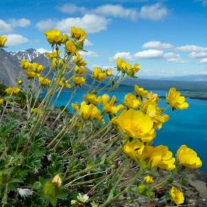
Hiked this trip with some friends and carrying my infant daughter. Winds were too strong to carry onto tthe summit that day with such a young passenger along. I found the trip down required extra care due to the loose and steep sections of trail. Gorgeous views of Kathleen lake and the ridges in the distance, lots of interesting flora in the throne.
