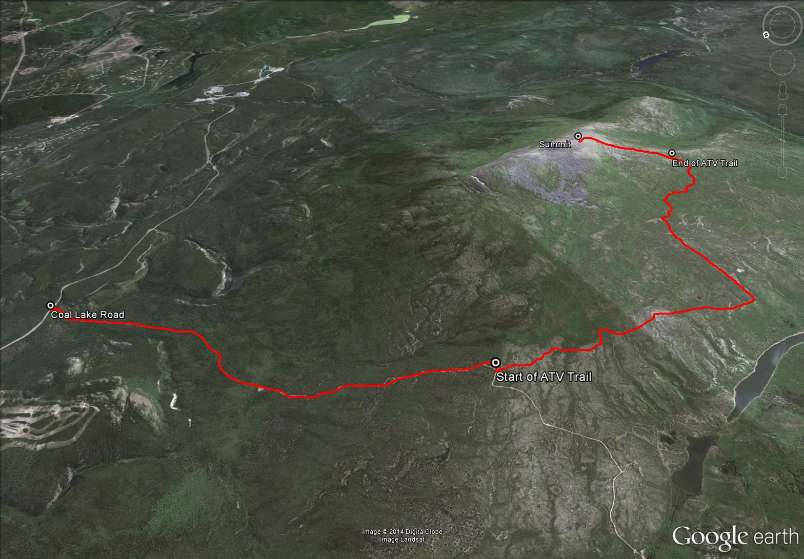
Total Distance: 23 km
Return Time: 6.5 hours
Elevation Gain: 891 m
Difficulty: Moderate
Region: Whitehorse
Traditional Territory: KDFN
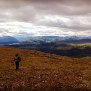
Golden Horn overlooks Whitehorse and is located behind Mount Sima, the local ski hill. Interestingly the Southern Tutchone name for Golden Horn, is 'Sima' and translates to 'red ochre'. The trail follows the Coal Lake Road up to an ATV trail which leads to the mountain. The views from the top are beautiful- you are overlooking Whitehorse, Lake Laberge, and all the mountains and lakes in the valley towards Carcross.
Drive south on the Alaska Highway from Whitehorse until you see a sign for the Mount Sima Ski Hill on your right. Turn here and follow the road to the Mount Sima chalet. Continue on the road past the chalet for about 1 km. You can park here where you see another heading up to the right.
Although you might be able to drive this road if you have proper clearance and 4-wheel drive, it is in pretty bad shape and may not be worth the effort. The road is about 4.5 km, and takes just over an hour to hike at a fast pace. The route described here includes hiking the road.
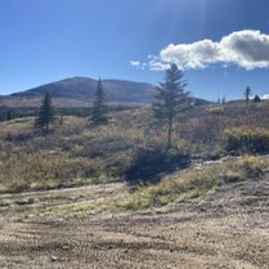
Start by hiking on the road to the right that leads up towards Golden Horn.
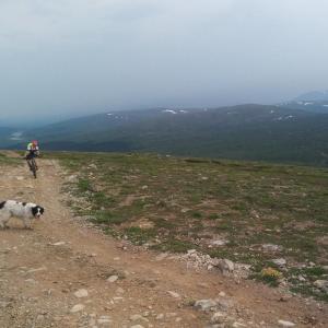
You will know when you are at the top of the road when you are above treeline and find an information kiosk regarding caribou in the area. Continue straight up, along an ATV trail. You will be following this ATV trail most of the way up Golden Horn (keeping left at any major intersections with other ATV trails).
The ATV trail heads south, parallel to Golden Horn, towards the southern end of the ridge. It may seem like you're actually getting further away from the mountain, but continue following the trail as it is much easier than bushwhacking. There are a few muddy, boggy areas on the trail, but they are fairly short.
After following the ATV trail south for about 2.5 km, it will turn abruptly left (east) towards Golden Horn. Shortly after, you'll start getting to the flanks of Golden Horn and start to climb up. At this point, the ATV trail starts to become bushier, but it is still fairly easy walking.
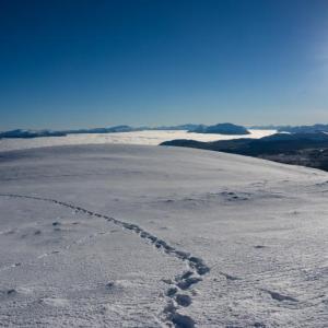
When the ATV trail ends, you should be higher in the alpine and should see some grassy areas that lead to the summit and avoid almost all of the small bushes. Follow these grassy areas up until you are in the alpine, and then head straight for the summit (slightly to your left).
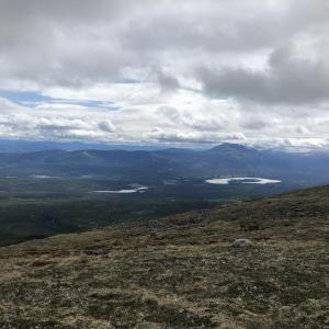
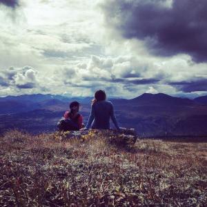
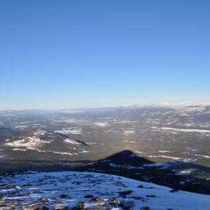
You are rewarded with a 360 degree view from the summit. You can see Cowley Lake and Mount Lorne to the east and even Montana Mountain to the south. Follow the same path back down. From the top, it may be hard to recognize the way you took up, so look for landmarks on the way up so that you don't miss the ATV trail on the way back down.
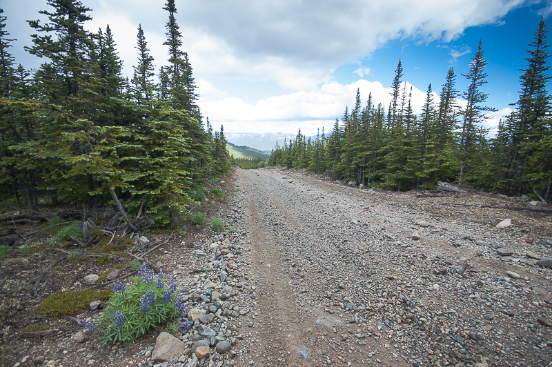
The start of the trail is on the Coal Lake Road.
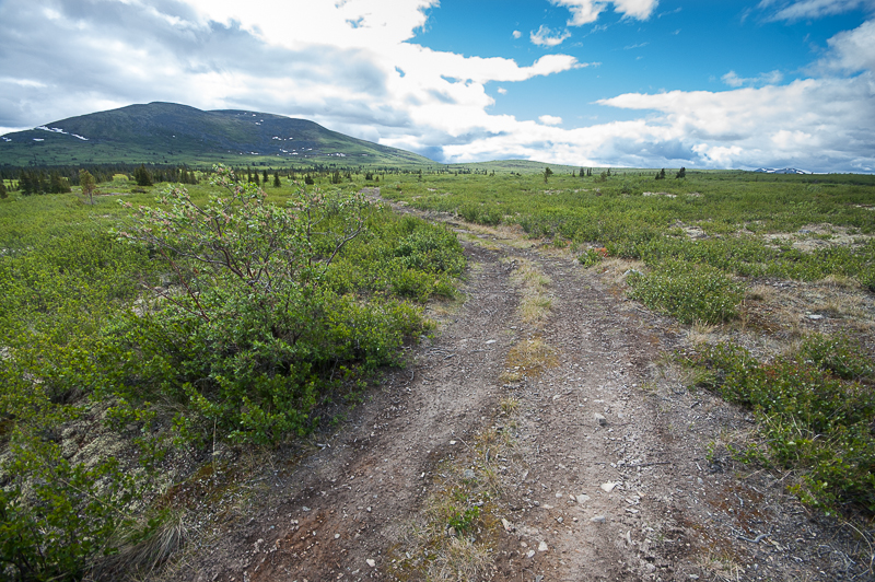
The ATV trail with Golden Horn in the background.
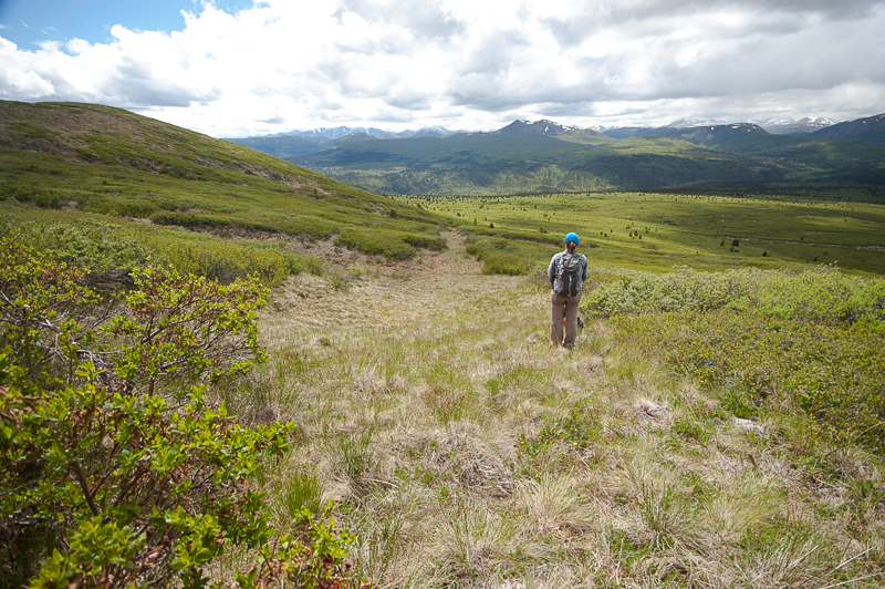
When the ATV trail ends, follow these grassy areas into the alpine.
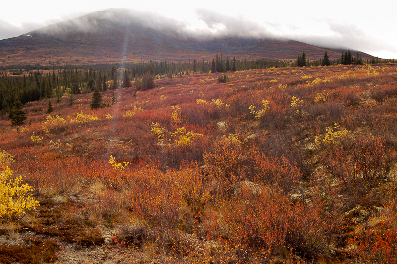
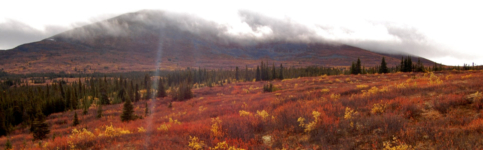
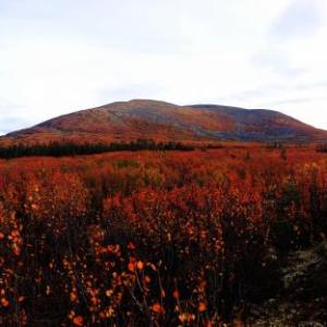
Golden Horn with its autumn coat.
The subalpine plateau below Golden Horn is beautiful in the autumn.
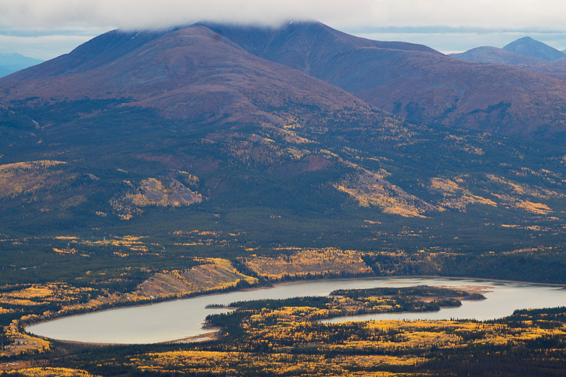
The view of Cowley Lake and Mount Lorne from the summit of Golden Horn.

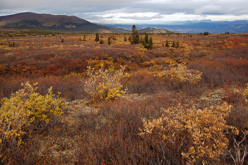
The colourful subalpine below Golden Horn.
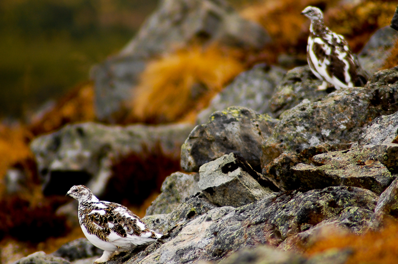
Ptarmigan with their winter plumage on the side of Golden Horn.
Aiden May 30, 2026
I’d like to start with I drive a 1” lifted FJ Cruiser (this is a relevant detail). My clearance is about 10 inches total. I decided to try driving up. I did make it to about 500m from the plateau/ATV trail but I scraped my skid pad and rock sliders. It’s doable but you need 4WD and it can get pretty tippy. They are not understating the road conditions.
From where we stoped it was about 14.4km round trip to the summit. It took about 4 hours total with stops for lunch, water and recovery (I’m not a very strong hiker when it comes to elevation). And the elevation gain was 539m.
Thankfully I had a great partner to hike with, while they were much more capable than me they went my pace and didn’t make me feel bad about being slow. Shoutout Amy!
I would not have been able to summit without driving up. I am a fairly beginner hiker and got tired and had to take breaks in just the 539m.
As for conditions on May 30, 2026:
We started hiking near the plateau around 8:40 and the snow was very firm. I only sunk in a few times on the way up. Even with the snow it was very doable. On the way back around 10:30pm the snow had gotten softer and we both sunk in quite a few times.
Great views, doable for a beginner if you can drive up. I think the difficulty rating is fair if you start from the bottom.
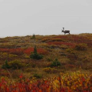
We also saw 4 caribou.

Ree March 29, 2025
Hiked up there today. Coal lake rd was nicely packed by the snowmobiles. I pushed my mountain bike up and had snowshoes on my back. Locked the bike near the kiosk and snowshoed the rest. There are lots of skidoo tracks heading in all directions so it was nice to have the gps track. The snow conditions were perfect and I was able to take a more direct route. It was tons of fun biking down, would highly recommend and shaves some time off. It was totally calm, sunny around 0 degrees, one other group of people and no large wildlife sighted.
Fafa March 6, 2025
Can you hike this in winter time?
Dacvan August 7, 2024
Soon gave up driving on the washed out dirt road: it is in nasty shape, even for a 4WD truck. Hiked up the road and the ATV track, as per the excellent yukonhiking.com write up. That route was too long and muddy and perambulating, so I hiked down off the north end of the mountain and bushwhacked back to the car. Not so bad: lots of caribou trails to follow. 4 km versus 10 km. It would be a good project for someone to blaze a trail straight up the northern ridge from the mount sima road.
jdecaron July 5, 2024
The major part of this hike is a snowmobile-all-terrain path. It’s wide, muddy, sandy & full of loose rocks. The view is nice at the top but the overall walking experience of the whole trail is bad, just go for an other trail.
Michael September 7, 2022
Hiked it September 6. Colours are beautiful right now and cranberries are delicious. Lots of grouse sitings on Coal Lake Road. Couple of mucky spots on the ATV trail and I did end up a foot deep in some mud. But it was not hard to wiggle out and walk around.
Accidentally left my dog's leash up on the mountain somewhere. It is brown with brass hardware. If anyone manages to bring it down let me know 689-8799. Otherwise I'll look on my next hike up.
@lf June 25, 2022
Did the hike today. Trai is easy to follow and has great views.
Still lots of water tho and mosquitoes were absolutely terrible *lol*
Jake September 8, 2021
Question for folks on here- is it ok to camp around Golden Horn? I was thinking of spending a weekend out there.
meredith September 2, 2021
Did this hike 3 days ago. The 3.5 km start of the trail is rather dull up an old road that I would NOT try to do in a car. You will almost certainly bottom out. It might not be a bad idea to bring mountain bikes though and start the route this way. It would have been especially lovely to roll back down this at the end of the hike. The trail was impassably muddy after to get to the plateau on the gps route. There is a way to get around this section by hiking straight and keeping the mountain on your left for a bit longer before turning toward it. The colours are amazing right now with the reds and yellows. This is a great hike!
Pippa L September 20, 2020
ATV trail is very wet and muddy in places, requiring challenging bushwhacking through bog to get around. Road is very rough. And colours are over now.
Kent September 7, 2020
Did it on September 6. A couple of really mucky parts that were a pain to get around. The biggest challenge I found was the length. I was pretty footsore by the time I finished. The elevation gain is gradual. I was glad there are a couple of stone markers, one with blaze tape, at the end of the trail prior to the open area of the peak. The trail is pretty faint at that point so it made finding the way back down a lot easier. The first/last five kms are rough. ATVs, quads or jacked up pickups only if you are looking to skip this part. A regular truck or SUV will probably get beat up too much.
Danette August 18, 2020
Hiked this on Aug. 18. Tried to drive up the road - it's in terrible shape, but we made it up a couple of km, then had to park and hike the rest of the way. Beautiful colours, no bears, beautiful day.
Patrick T. July 20, 2020
Great hike with some interesting wildlife encounters (Caribou, Lynx & Porcupine), some muddy areas in the sub-alpine however there are some bushwacking detours to get you around the worst of them.
On a side note, my wife lost her sunglasses in one of the muddy areas near the base of the mountain if anyone finds them could you please call 332-7288? Thank you!
Tammy June 10, 2020
Hiked June 9. Beautiful day to hike. 5 really boggy sections mid way through hike that you are going to get your feet wet and dirty. No way around so suggest hiking boots with gaiters. We wore trail running shoes and had wet, muddy feet. But the 360 degree views are well worth stinky wet feet! Just over 6 hours return with lunch at the top.
Meaghan May 24, 2020
Hiked this on May 23. There were still some 3ft deep snowy patches (one at the top of the ATV road and a few on the way to the summit) there were some boggy sections as well. We made it up and back with mostly dry feet.
I lost my binoculars on the summit (somewhere on the left side) if you find them, please contact me at 416-710-2113. Thanks!
Carly May 18, 2020
Hiked this on May 18th, and the trail was extremely wet with a combination of swamp like portions and snow patches. We managed to almost get to the ridge but the deep soft snow / puddles held us back. Would recommend maybe doing this hike later in the season maybe starting mid-June or bringing very waterproof shoes and pants. Took us 7 hours round trip without getting to the top due to all the terrain obstacles. The view was really incredible though.
Rhiannon June 26, 2019
Hiked this on June 22. It was very buggy along the Coal Lake Road. The ATV trail is super easy to follow. Though it feels like you're bypassing the mountain, stick with the trail because it will turn towards Golden Horn. A few wet, boggy sections. Easy walking for the most part, with a short, steep climb to the top.
Mark June 17, 2019
I ran the trail on June 16, 2019. I had a mix of hail, sleet, rain and sun. The views were great from the top.
There is a lot of water and mud on the trail, in spots there was no way around it, so you are likely to get wet feet. The ATV trail is clear and easy to follow. About ½ along the ATV trail it goes around a marsh, be careful where you step. My dog jumped into a hole, on the trail, and completely submerged. She was on a lead so I pulled her out but I do not think that she hit the bottom.
Peter May 25, 2019
Hiked it on the 24th of may. The trail was nearly free of snow, just a few patches close to the summit, which you can circumnavigate easily. Be aware of some muddy parts,i wpuld recommend proper hiking shoes to avoid wet feed.
Once on the top you get nice views, i personally think it's worth to step down a bit to get a free view of the yukon valley.
Geoff September 29, 2018
We biked up to the top from the copper haul road. Had to push our bikes near the top but it was a fun descent. About 4 hours total including stops.
Ben May 26, 2018
Went up May 26 and got stopped by massive puddles and km of soggy terain just passed the atv trail. Beautful hike, but its worth waiting 2-3 weeks for the trails to dry up.
Alice March 19, 2018
Tried this hike yesterday, but had to give up. The snowmobile trails petered out after a kilometre or so. Even on snowshoes we were breaking through the crust into 3 foot deep snow.
G Snider September 10, 2017
A friend and I hiked to the summit of Golden Horn Mountain yesterday (September 9). It was a rainy day yet, with the fall colours, it was a very fulfilling hike. The boggy areas weren't too bad, but the low spots had filled up with water by the time we came down--nothing treacherous though.
Although we did not experience the amazing 360 degree views from the top, because we were in a mountaintop cloud when we summited, we did see six caribou near the top.
A gorgeous fall hike!
kyliestravel August 14, 2017
Hiked this trail on 13th august. Lucky enough that my Yukon mate had no fear driving up the "road" to the start of the ATV trail - I most certainly wouldn't! But it saved us a hike that I think would'nt have been worth it from my point of view. From the ATV trail is is just a long flat hike until the base of the mountain and a short hike to the summit. Its pretty easy hike but I'm sure with the first section it is moderate cause its just time consuming. Beautiful views.
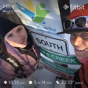
Meghan and Lara-Rae March 21, 2017
March 11th, 2017
Start of the morning temps were -33C. We waited for the temps to warm up a little before hitting the trail head. -24C and we were off, skies were bright blue not a cloud in the sky. Beautiful trek up through the bush. Skidoo tracks had the trail packed down for easy hiking. We were greeted with a happy bunch (10 in total) that hiked to the top of the ATV trail and were all tobogganing down. I would highly recommend this idea, perfect sledding trail!!
Our plan was to get to the top of Golden Horn but there was no way this was happening today. WAY too much snow!! We followed skidoo tracks to the right side that took us to the top of peak. We followed the tracks until they ended. Had hot soup and cheers with a beer at the top. We managed to find a little hill to hide behind to block the wind as it was very brisk at the top. We warmed up quickly on the trek back down. Going down went very fast.
Temp when we got back to the truck was -15C.
Beauty day for a winter/spring hike!
Things to note:
1. The (trail head) ATV road to the right is labelled COAL LAKE
2. The Caribou Kiosk no longer has any signage in it. But the stands are still there!
Can't wait for the snow to melt to attempt this one again!!
Happy Hiking!
Miriam August 29, 2016
Did this hike August 28. The kiosk with info about caribou doesn't have any info, just an empty stand but is a good marker. The description isn't kidding when it says it seems like you will be heading in the opposite direction of the mountain, but the trail does swing around eventually. Some boggy areas, but we were able to pick our way around without getting our feet wet. There were a few hunters on their atv's later on in the day. Many atv trails, landmarks are a good idea for finding the way back. Took us 8 hours but we stopped and ate a couple times and hung out on top. Fall colours in full swing.
Chelsea June 29, 2016
Hiked the trail June 26th. Gorgeous day, dry and sunny. Even so, lots of wet muddy areas. I was glad to have sturdy boots on. Saw two caribou at the summit! I would agree wholeheartedly with the comment in the description about looking for landmarks once you leave the ATV trail -- it was difficult to find my way back once I started to head down from the summit. Took me 7 hours total, but I stopped to appreciate the view a lot :)
adam June 29, 2015
Biked the ATV trail from the "start of ATV trail" point on the map here over to Fish Lake. 6 hours and lots of pushing of bikes later, we arrived. I wouldn't say that i'd recommend the route, but I'm glad to say that I've done it. I'd say a 2 day overnight hiking trip would be better suited to the route.
Jan Priessnitz April 27, 2015
We´ve reached the top eventually, but I´ve got my lesson, ´cause I underestimated the situation and didn´t bring snowshoes with myself so on the huge plateau which you have to get through it, I was struggling due to breaking down in the 1 meter deep snow. It was really physically even mentally exhausting! Due to whole sunny day the snow was extremely fragile. Last steep part was already ok, but still with some snowy/icy parts and there were already some dry parts or just with rocks sticking out from snow so I dig up steps at that icy parts when my hikemates got up nicely because of crampons on snowshoes. The conlusion is that I highly recommend to take snowshoes even in May! Better to have it and don´t need it than oposite way ;). Other than that it´s really nice hike with fabulous views from the top :). Enjoy!
Travis November 14, 2014
Took the dog on a hike to the summit of Golden Horn today (Nov 14). The trail has been fairly well packed by snowmobiles and I was able to wear trail runners almost the entire way. I had to put on snowshoes for the last 500-700 metres to get to the summit. Great hike with 360 views and beautiful weather. Don't let the oncoming winter stop you from getting out. Just remember to take the necessary gear to account for colder weather and shorter days and have fun.
Marko Marjanovic July 1, 2014
Anthony is right, the ATV trail is a better route because it avoids all of the bushwhacking. We have been meaning to update this route for a few years, and your comments finally prompted us to re-hike this yesterday and update it so that it follows the ATV trail most of the way up.
Anthony DeLorenzo June 29, 2014
I've done the bushwhack as well (in shorts, of course) but there is an ATV trail that leads straight to the base of the mountain that is a much better route. Look for it on the satellite imagery you can see it easily.
John Hynes June 27, 2014
Attempted this hike just yesterday on June 26th. I started in downtown whitehorse, and had some mixed success hitchhiking up to mt. Sima. Along the way, I almost ran into a mama bear and her cub, which prompted me to be extra cautious for the rest of the trip - luckily, I didn't run into any other bears.
As the previous comment pointed out, the two kilometers or so of bushwacking from the end of the atv trail is brutal. That 2 km took me over an hour, and getting wet and scratched up was unavoidable. I ended up getting so exhausted from that part of the hike that I didn't make it all the way up the summit! I gave up when my legs got a bit shaky just 100-200 meters from the north peak.
On the brighter side, the views were phenomenal, and I thoroughly enjoyed the other parts of the trail. Bugs were there, but nothing compared to Saskatchewan mosquitoes. There was plenty of evidence of caribou on the plateau, though I didn't spot any wandering around. All in all, it was a very nice day hike, (took me about 8 hours, hitchhiking included) but I think I'll be sticking to official trails from now on.
Bob Holmes June 17, 2014
Three of us went June 15th. The 4.8 km hike up Coal Lake Road is pretty dull with ATV's roaring by. Once we left the road, the animal tracks petered out within 5 minutes and we bushwhacked for over an hour to get to the foot of the mountain. Forget about trying to aim for the left or right ridge - just get to the mountain using the line of least resistance. Footing was very bad getting there, with running water and hummocks and tangled willows and rocks. I think all of us fell in water a couple of times with feet tangled in the willows, and got all scratched up. No shorts please. Once at the mountain, it is a slog up the rockfalls with more willow tangling you up. It really only gets easier walking near the top of the mountain, and then the views really are spectacular. Saw a couple of caribou feeding. They seemed to have no trouble getting around! After lunch, then all was repeated, except it got buggy. The headnets were essential. Also heavier boots would be good. Our light trail hikers were not ideal. It was very tiring and hard going and took about 6 hours all told with lunch. Maybe later in the year would be easier with less water to navigate.
Mike January 26, 2014
Beautiful January day in the Yukon. Up to the ridge of Golden Horn on Saturday the 25th. Couldnt have asked for better weather. Lucky and caught a couple snowmobile tracks to and from the base made the slog across the plateau not too bad.
Marko Marjanovic January 23, 2014
Splitboarded up the Coal Lake Road today to the alpine area below Golden Horn. It was 9°C! Sunny and warm, and not much snow. The road up was packed and had the usual snowmobile bumps, but the snow was still soft for the ride down.
Leah September 23, 2013
Beautiful hike but there are no marked trails to the summit. Mostly bushwacking but it's fun and you get a great workout. There are some animal trails but they quickly come and go.
Head in the direction of the summit and eventually you will make your way through all the bush.
When the bush gets higher then your hips there tends to be swampy land underneath.
Lots of unseen tiny creeks. You will get wet feet so wear good waterproof hikers.
Great hike!
Julie Cook September 15, 2013
Alastair and I hiked to the ridge that overlooked Coal Lake with a couple of friends on Sept.14th.
If you want to see incredible panoramic views and soak up the Fall colors, you are in for a treat. Pack a lunch and a thermos of coffee, and be prepared to be in awe of the Creator and Creation !
It is spectacular .........
Alastair Cook September 1, 2013
I didn't make it up to Golden Horn itself, but my wife and I hiked the Coal Lake Road that leads to it on Aug 31st. We made it a several hour return hike, and got way above the tree line, into the alpine and spent a few hours continuing to walk the road, which is very well defined, but rocky and uneven in lots of places. Easier on foot than using a vehicle I think. We did in fact meet some people in a rather nice pickup truck on the higher elevations, and he said it was hard on the truck, for sure. Either way, once above the tree line there are great views in all directions...Lake Lebarge to the North, the enticing mountains in the Wheaton Valley area to the South, and Grey Mountain etc behind you to the East as you are going up.
Really enjoyed the wonderful time walking up in the alpine areas on a decent 4x4 road with the place almost to ourselves. I think perhaps the Coal Lake Road deserves a separate listing, as it is a destination and hike in itself, with people deciding when and where they want to turn around.
For us it was a very refreshing and inspiring day out.
