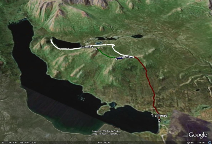
Total Distance: 7 km
Return Time: 2.5 hours
Elevation Gain: 323 m
Difficulty: Easy
Region: Whitehorse
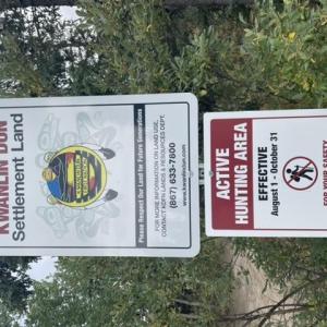
Traditional Territory: KDFN
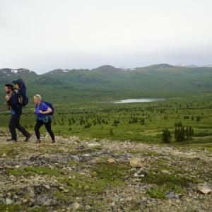
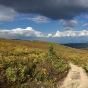
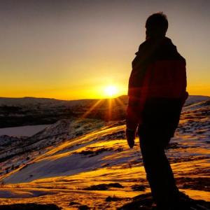
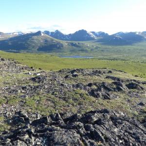
This trail starts at a high altitude and is so close to Whitehorse that you can get off work and be walking along a ridge in the alpine in no time. Once on the ridge, there are many options and ample opportunity for exploring.
NOTE: The Fish Lake area falls within Category A Settlement Lands of the Kwanlin Dun First Nation. Please respect their rules and land, particularly avoiding the area during the hunting season (which starts August 1st) between the hours of 5 pm and 10 am.
From the intersection of the Alaska Highway and Hamilton Boulevard/Two-Mile Hill in Whitehorse, drive 3 km north on the Alaska Highway and turn left on to Fish Lake Road. Follow this road until you reach Fish Lake (about 15 km). At Fish Lake, you can find parking right away, or try to continue driving for another 600 m to the trailhead along a narrower road that leads right, along the berm at the lake outlet. There is signage at the parking area at the trailhead.
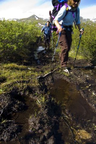
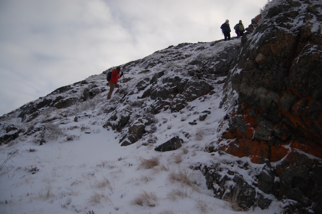
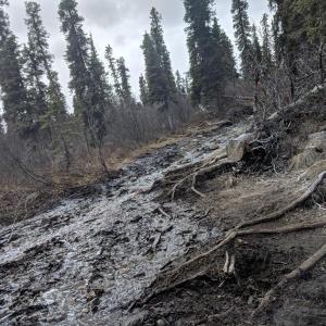
The trailhead starts right from the parking area with a well-worn trail through the trees. It is quite gradual at first. Once the trail starts climbing, it becomes more braided and can be muddy early in the season or after a rain.
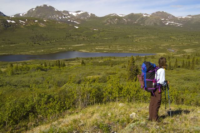
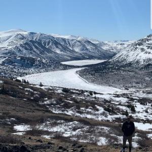
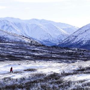
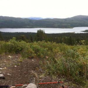
After just under an hour of hiking, you will reach the treeline with a short uphill section remaining to reach the saddle on the ridge with a view of Fish Lake as well as the Bonneville Lakes and Boundary Mountains on the other side. See below for extended hiking options.
EXTENDED HIKE OPTIONS
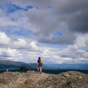
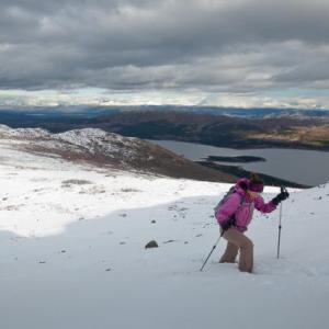
From the saddle you have many options to explore. To the right (north) is a nice mellow ridge to explore via a ATV trail. To the left (south) is another trail that leads up to a small summit. The views from here are even better than from the initial saddle and only add 2 km round trip and 70 m elevation gain to the hike distance here.
From this first summit you can continue on to an even higher ridge beyond (Summit 2). This adds a bit more distance and elevation gain (an additional 2.4 km and 120 m elevation) but if you have the time it is definitely worth it. There is a less defined trail here, which then disappears close to the ridge and becomes quite steep.
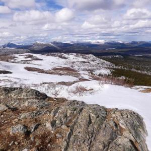
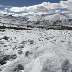
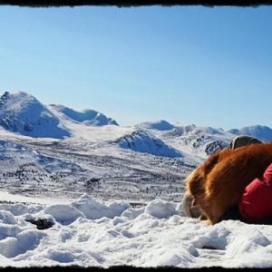
Follow the same trail as the summer path. The total time is roughly the same. Snowshoes are recommended and in the alpine expect high winds and potential wind-packed snow and drifts.

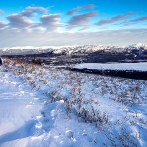
The trail starts through the forest, climbing gently up to the alpine.
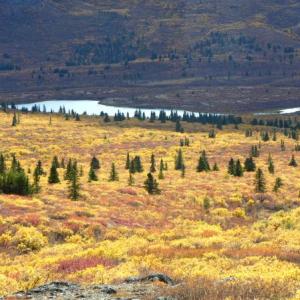
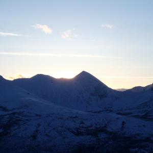
Looking over Bonneville Lakes from the top of the ridge.
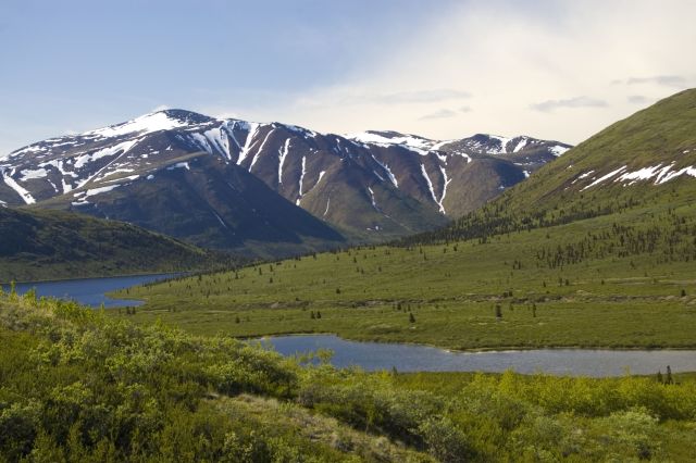
Looking towards the south end of Bonneville Lakes.

From the ridge top, you can continue up the path towards the first small summit.
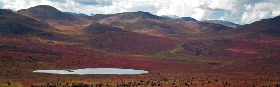
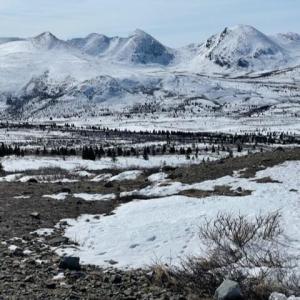
The alpine explodes into colour during the fall.
The wind-swept slopes are often a great hike in the winter too.
Joa March 28, 2026
Anyone hiked in last week? Are snowshoes needed?
Frenchie August 25, 2025
Was out on this trail a couple days ago - Aug. 23 - and found the majority of the trail dry and in good condition. There was only a short section of dampness/slight mud on the approach to the highest peak. (Views are amazing!).
Following an All Trails Loop posting of the area, we proceeded down the peak towards the lakes in the Bonneville Lakes valley, which required a fair amount of bushwhacking. Once in the valley, following the horse trail, the going was easier and views, wonderful!
(The trail name on All Trails is Fish Lake Hill Loop, if anyone is interested in seeing how this trail here and the one I travelled on Saturday blend together).

Em October 1, 2024
Started the hike around 12:30, a big foggy near the top. We just missed a pack of 6 wolves up on the saddle according to hikers coming back down. About an inch of snow in some spots and mostly dry in the treed parts. Not icy at all today (perfect for snowballs)!

Aaron Weber July 1, 2024
Hiked June 21. Cloudy evening, 2.5 hours round trip to the first summit. Gorgeous views over Fish Lake and of the smaller lakes and mountains behind. Short drive from Whitehorse. Trail was in good shape, no snow on the trail.

Rhiannon June 15, 2023
Hiked to the first summit last weekend. Trail is dry all the way up.
Yukon Hiking April 15, 2023
The trail was in great condition earlier this week. Well packed all the way to the saddle and then patches of snow and rock to the first summit. A little icy on the way down on any steep parts but poles and/or ice spikes are a big help.
Get up there before the warmer spring weather makes it tough going during the melt!
Shailyn D September 12, 2022
After racing leg 6 of the Klondike Road relay the day before, I switched my hiking plans from a harder hike to Fish Lake (I was still keen to get out and enjoy the autumn colours and temperature. I have probably hiked this one easily 20 times, but the view from the top is still always so impressive - especially this time of the year (Sept 11). Easily the most people I have ever seen on the trail (at least 40 people), but with the colours and how accessible it is, makes sense. Nice to see so many people embracing the outdoors and our local trails. No signs of wildlife.
Yukon Hiking August 28, 2022
This is a reminder that this time of year citizens of the Kwanlin Dün First Nation use this area for hunting from August 1st to October 31st and they ask that people AVOID the area between 5 pm and 10 am.
Liz B July 27, 2022
Hiked to summit #2 of Fish Lake on July 27. The trail was a bit wet and muddy in some sections through the trees but there was always an alternative route so you never had to walk through the mud if you didn't want to.
Lots of horse poop on the trail which I found a bit annoying but hey, what can you do.
Mosquitos were pretty bad through the trees and the blackflies joined the party once we got into the alpine. Bug spray was a lifesaver for us, especially since we had our 9 month old in his backpack.
Ridge walking was beautiful, lots of wildflowers are blooming right now making for some great scenery.
Yukon Hiking July 21, 2022
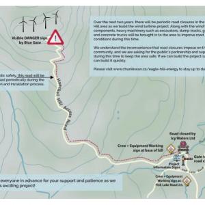
Notice regarding construction on the Haeckel Hill Access Road affecting the FISH LAKE ROAD (and therefore potentially access to hikes like Fish Lake and Jackson Ridge)
INFO FROM Eagle Hill Energy Limited Partnership:
Over the next two years, there will be periodic road closures in the Haeckel Hill area as we build the wind turbine project. Along with the wind turbine components, heavy machinery such as excavators, dump trucks, graders, and concrete trucks will be brought into the area to improve road conditions during this time. We understand the inconvenience that road closures may impose on the local community, and we are asking for the public’s partnership and support during this time to keep the area safe.
Check out the website for regular updates before you head out: https://www.chuniikwan.ca/eagle-hill-energy
Chris May 21, 2022
May 21-2022
Beautiful day but the trail has a lot of melting snow. Hike is great just make sure you bring tall boots and wear pants that can get wet. Trail is quite slippery.
Bonnie March 10, 2022
March 9, 2022- Trail was in great condition! Beautiful day for a nice hike.
Lauren July 12, 2021
Went up July 11th. VERY buggy in spots, but they tend to be better up above the treeline where there's wind. no animals spotted. we got up to the first summit and down within 2 hours at a pretty brisk pace. mucky in spots and lots of horse dung but there are plenty of side trails to avoid those spots.
Rhiannon July 1, 2021
Went up today. Trail is mostly dry, just muddy/creek-like in a few spots. It was very buggy.
BonD June 9, 2021
June 7- Trail was still quite wet and muddy. There was a fair amount of snow near the top, but we were able to make our way through it.
Mason Bramadat December 20, 2020
Last night my tent was blown over and most of my gear went with it. I was camped near (slightly beyond) Summit 2 on the above map. Some of the gear is still there, probably snow-covered and damaged. There is also a green backpack lower down on the ridge that belongs to me. If anyone is in that region could you please recover any gear you come across and call (867) 333-2015? It would be HUGELY appreciated, almost all of my outdoor gear is there.
This all occurred because the wind blew over my tent, scattered my belongings and forced me to call a police rescue. I do not recommend overnight camping on that ridge, unless you are sure of conditions.
Kyle May 7, 2020
Bonneville lakes are a nice addition to this hike, lots of room at the summit to explore.
Emily May 5, 2020
Still snow on at least half the trail. Pretty wet and muddy in the lower parts of the trail. But still beautiful! Lots of mosquito eggs in the puddles but no actual mosquitos yet.
Denise April 30, 2020
Hiked this trail April 27, 2020. Nicely packed till you reach the alpine, afterwards it's bare or you can mostly walk around snowy patches.
Fantastic views and fast reward since it takes only about 1 hour to get up into the alpine and it's one of the few hikes that you can easily do at this time of the year.
You can make this hike has short or long as you like... there is certainly a lot of terrain to explore and the views are awesome!
Jeremy and Jen August 27, 2019
August 27, 2019. Great weather 16 at the parking and 10 and a bit wibdy at the ridge with a frw changes of layers as some ice pellets came down midway. One hour to the clearing and ridge.
Melissa September 3, 2018
Hiked up Fish Lake ridge and to the summit (the one that overlooks the larger Bonneville lake) today. Saw a big caribou up I the alpine near the summit, beautiful rack got some great pictures with the caribou and the fall colours. Very busy day on the trail, not so much when going to the summit bu deffon the saddle and the first summit. Great local hike and popular for a reason. Stunning 360 views. There are loose rock sections that are pretty steep but overall decent, saw lots of hikers with poles and they would be handy.
Emma June 17, 2018
Super muddy still and getting really eroded by the run off. Waterproof hiking boots or shoes a must. On the plus side you don't need to bring water for your dogs still.
Jackie May 22, 2018
Hiked May 20. It's dry for the first 10 minutes or so, but after that, what's normally the path is currently a mini-river on account of meltwater for most of the way up. Still a decent amount of snow on the path once you get above the treeline, but we ran into a horseback riding group on the way down that turned the pretty compact snow/ice into a slushy, muddy nightmare. Would strongly recommend waterproof boots for anyone planning on hiking it over the next while - there are some parts where you can skirt around thw water/mud by going through the bush, but even then, it's impossible to conpletely avoid it. DO NOT attempt in just running shoes unless you enjoy trench foot.
Tiphaine May 4, 2018
I've been here today (May 4th) and the trail was really good. Compacted snow on the trail to the top.
Sue April 30, 2018
I hiked up on April 28. The snow is getting punky and its easy to fall through the top crust. The conditions were mixed icy, snowy, punky and bare ground. It was sunny and beautiful, and very windy and cold up top. Probably best to wait a couple weeks to fully enjoy this hike.
Kalah January 26, 2018
Went up today and the trail is in great condition! No snowshoes needed. The wind has caused some drifts past the treeline but finding the trail is no problem and they're no deeper than mid calf.
Michael & Shaeron December 26, 2017
While on vacation in Yukon during September 2017 we were admiring the beautiful fall colour at Fish Lake. Chatting to someone there we were informed about the trail and decided to give it a try. Being somewhat older we found the path up through the trees a bit of a challenge but once up in the alpine the path was much easier.
Reaching the ridge the views were fantastic. It was somewhat surprising to see how much more sparse the trees and vegetation were on the Bonneville Lakes side compared to the Fish Lake side, and how different the landscape appeared on either side.
The were no bugs, the weather was beautiful and the fall colour was magnificent. The trail was definitely one of the highlights of our holiday.
Liz Barker June 22, 2017
Hiked this yesterday. Trail is in good shape, mucky spots have pretty much dried out. Bugs are out in full force, we had clouds of them following us all the way up to the summit, we passed a few people who turned around and went back down because the bugs were so bad. Bug spray is ineffective, I would recommend bug nets if you're hiking on a calm day with no wind (which is unusual but happened to us). 2.5 hours from start to finish with lunch at the summit.
taibhsearachd June 4, 2017
Hiked this early this morning (arrived at the trail head by about 7 a.m.). In spite of the early in the day start, the trail was still wet and muddy in parts, so be prepared for that. It was the perfect temperature for hiking, and there wasn't any wind, not even at the top! No mosquitos either, which was a pleasant surprise.
In her review, kyliestravel said it took her 1.5 hours there and back. She must have been flying, because it took me 2.5 hours. Granted, I was not hurrying, but I still think most people would need more than 1.5 hours to do this hike and have time to enjoy the amazing views at the top.
kyliestravel May 28, 2017
I did this hike after work on 24th. The trail was pretty boggy in some parts and elders everywhere! I am definitely going to come back through soon and cut down and break a better trail. The views were amazing, but the winds were insane.
The hike is super short - To the 2 summits and down took 1.5 hours.
Really nice hike, but the lake is still frozen
MeghanM April 8, 2017
Trail was in great condition, nice and packed, Thursday around noon, not too icy. Extremely windy at the top, as usual! Some of the snow on the ridge has already melt or been scoured away. Note the access road before the trailhead was pretty rutted and would be a mess later in the day once things get slushy!
Jason L February 19, 2017
This is a nice and straightforward hike. The trail is quite packed-down at the moment (no need for snowshoes). It's an easy hike on the way up, but fairly slippery on the way down. Once you're up on the ridge, you can walk along to the right or the left and enjoy spectacular views in all directions. It was very busy this afternoon - multiple groups hiking, recreating out on the lake, and taking photos of lynx spotted along Fish Lake Rd.
Liz Barker February 18, 2017
My husband and I hiked the Fish Lake trail this morning. We threw on our head lamps and got to the top just in time for the sunrise. The sky was clear and there was next to no wind (which is not usually the case in my experience). The trail is packed and easy to walk on, absolutely no need for snowshoes. My husband and I both wore our hiking shoes, I also wore my micro spikes(the kind you get at Canadian Tire or Marks Work Wearhouse). I had no issues getting up and down but my husband fell twice on the way down in a couple steep, slippery areas. The hike is doable without spikes, just be careful on some of the steeper sections. We also saw 3 lynx along the trail, two adults and one baby. All in all one of my favorite hikes in the Whitehorse area!
Danielle koop January 9, 2017
Trail was awesome! Packed until the very end which had some pretty deep snow, if youre looking for a leg workout though it should still doable. Got to the first peak around 2 just in time for some beautiful sunshine! Definitely do this hike if you're humming and hawing
T&C November 29, 2016
What a gorgeous trail! My husband and I are in Whitehorse on vacation for a week and this was our first hike of the trip yesterday. What a great first trail! There was no need snowshoes yesterday as the trail was packed down (but it snowed today - so perhaps you will need them!) Just beautiful views at the top (along with a chilly wind once you exit the treeline!) A very doable consistent incline. Well worth the hike. Enjoy!
Jane Doe November 19, 2016
Wow, what a trail
Graydon November 7, 2016
I lost a blue glove on the road. If anybody finds it let me know!! Thanks
Liz B November 6, 2016
My husband and I hiked up to the first summit today (Nov 4). The trail was in good shape, packed down and easy to walk on, no need for gaiters or snowshoes. Some spots along the ridge had deeper snowdrifts but nothing crazy. I consider myself to be in decent shape and the hike was fairly easy. This was the first time we hiked this trail and all I can say I wow! Amazing views at the top and so close to Whitehorse. Great day hike!
Jo October 29, 2016
Hiked to fish lake on Sat Oct. 15th in snowy conditions. Made it to the second summit at GR 845720 1580m. Great view really close to town and endless opportunities to add-on and make it a full day in the alpine.
Audrey Bouchard August 22, 2016
This was a real treat to hike Fish Lake on my last day in the Yukon! The weather was about 25 degrees down the mountain, and up it was snowing and it was beautiful! It took us 2h10 and we spent 15 min up to admire the landscape! Very nice trails, it's a place to go and explore!
jpump April 25, 2015
hiked to the second summit today. lovely day, lots of sunshine and a breeze. The path was a little slippery on the way up to the first summit and by the time we got back in to the tree line on the way down it had become much slushier and slippery - caution is advised until the snow is gone. Good pair of hiking boots is strongly recommended. muddy in spots but overall the trail was good and it was a great day.
Ian Smith March 2, 2015
Real nice hike. It was pretty slippery with the warm weather so we wore snowshoes just for grip. Hope to get back again soon.

Karen February 16, 2015
Great hike with beautiful views at the top. I'd say this is more easy to medium, particularly in the snow. We were advised by another visitor to park at the lake since the road up to the trail was slippery and only one lane. The snow was packed enough that we didn't need snowshoes until the walk along the ridge. And we were glad to have them!
Elise Maltin July 29, 2014
Wonderful hike and perfect description. I just wanted to let you know that Yukon Electric is doing major work at the dike at Fish Lake. We parked in the big parking area and we were escorted through the construction area by the workers. It just threw us off a bit as we hadn't done the hike before so we weren't exactly sure where to go. Hopefully the work will be completed soon and it will be back to normal. We couldn't drive up that little road as it was blocked off.
Shailyn Drukis June 22, 2014
Hiked fish lake yesterday for the solstice. The trail was in pretty good condition, not too much mud. Just watch out for the horse poop on the trail! The top of the summit was incredibly windy and nippy, but nothing proper gear can not handle ;) Incredible views! I really enjoyed this hike!
Mady March 22, 2014
My dog and I went to the first summit today without snowshoes. The trail is packed nicely although the wind was biting at the top. I'd recommend some YakTrax for coming down though. Lots of opportunity to slip.
Marko Marjanovic January 3, 2014
We walked up the Fish Lake trail today without snowshoes. It took just under an hour to get to the alpine and the trail through the trees was packed enough that we didn't need snowshoes. Once in the alpine, the packed trail stopped, and we tried to make our way further but kept falling through a hard crust that left us post-holing up to our knees. We turned around before reaching the view of the other side as the sun was starting to set.
Marko Marjanovic October 6, 2013
There is snow up in the alpine now. No snow on the trail through the trees. Only about an inch in most places. However, in the snow drifts the snow can be about 6 inches - higher than hiking boots - so gaiters would be useful.
MorningStar Leon September 7, 2012
My favourite place of all, and easy to get to, summer or winter. In summer, I really need mosquito repellent here!
Veronique September 7, 2012
My 4-year old daughter and I hiked the trail to the ridge last Monday and had a great time. It took us about 2:45 round-trip, including a 20 minutes lunch break. It was an easy hike, and perfect for younger kids just starting out. Great views of the area as well!
Rebecca September 7, 2012
We hiked this in early September with our 3-year-old. He made it a much slower hike, but the colors were gorgeous, the trail well-defined, and there were quite a few other hikers on the trail as well. A fantastic hike close to Whitehorse.
