Total Distance: 15 km
Return Time: 6.5 hours
Elevation Gain: 1324 m
Difficulty: Difficult
Region: Kluane
Traditional Territory: CAFN
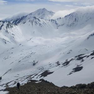
Mount Decoeli is a pyramidal peak you can see from Haines Junction. From the summit on a clear day you get a sweeping view of the mountains, valleys, and icefields of Kluane National Park.
From Haines Junction, drive north along the Alaska Highway for about 20 kms. Just north of the Bear Creak Summit sign, there is a pull-out on the left.
Note: This hike is within the Kluane Wildlife Sanctuary and not in the National Park & Reserve.
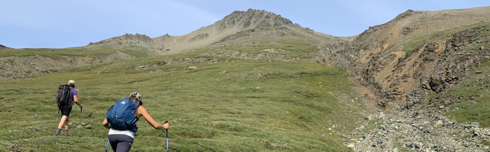
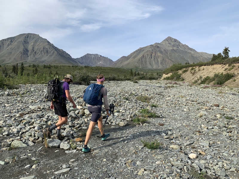
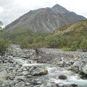
Start by walking to the south-end of the pull-out. Continue walking in the grass towards the trees, and you should come across an obvious wide path through the forest. Follow the path until you reach the creek bed.
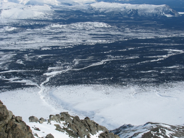
At the creek bed, turn slightly right, and head up along it. Continue following the creek. You may have to dodge into the bushes every once in a while, and you may want to cross the creek here and there. Your actual route will depend on the height of the creek, but overall the going is fairly straightforward.
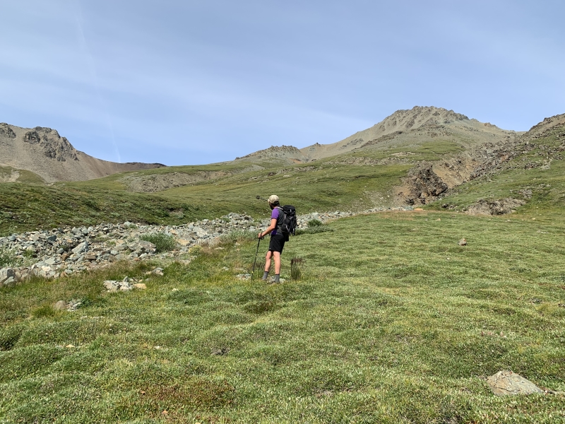
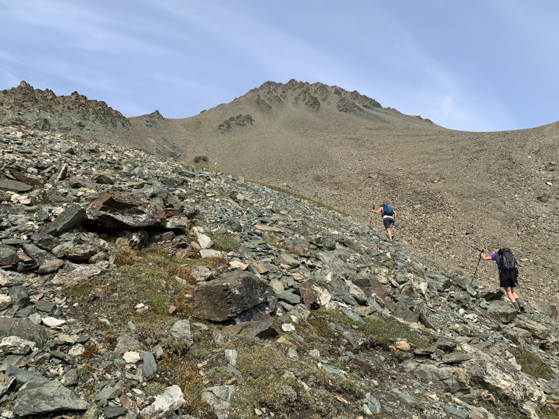
After about 5 km you will reach the base of a rock glacier. To your right is a worn trail that leaves the creek bed and starts climbing up onto the grassy slopes. Follow it upwards.
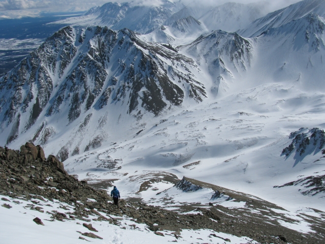
Hiking on the grassy slopes is a relief from hiking on the creek bed, but you will now start to climb upwards. Above you is the summit of Decoeli. You will be heading slightly to the left of the peak. Angle towards the high grassy slope on the left of the peak.
You will soon leave the pleasant vegetated slopes and eventually reach the talus slopes that lead to the summit. Hike up the talus slope to the shoulder below the summit (again, heading slightly to your left). Then look up and hike the final talus slope to the summit. This part is not particularly fun, as the rocks are loose and for every two steps you take up, you will slip one step back.
Eventually your hard work will pay off and you will reach the summit. The views are incredible in every direction. You can see deep into the St. Elias icefields as well. Return the way you came up.
There isn't much snow in this wind-swept region, so winter doesn't provide too many challenges. The creek is frozen and packed snow can make the going fairly easy. You are however still in avalanche terrain once you reach the base of the mountain and moraine.
From the south end of the pull-out, there is an obvious trail. You will follow along this trail which is along-side the creek for about 5 km. At about KM 5, you will reach the base of a rock glacier.
The rock glacier is a decent place to camp if you are staying overnight. It is at the base of the mountain and right before any steep inclines.
From the moraine, walk up the far scree ridge to the right side of the valley. Follow the ridge all the way to the summit. It is basically scree the whole way up for the most direct route. If you head further up the valley there is a less direct route with less scree. Return the same way.
Once you exit the trees, the route follows the creek.
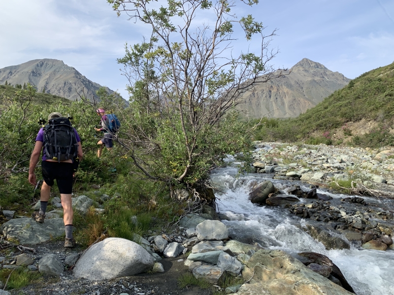
There are a few sections along the creek where you have to dodge into the bushes to avoid crossing the creek.
Once on the alpine slopes, aim for the high grassy slope on the left and angle up to the rocks. Decoeli summit is the peak on the right of the photo.
The transition zone between the soft grassy slopes, and the hard rocky talus.
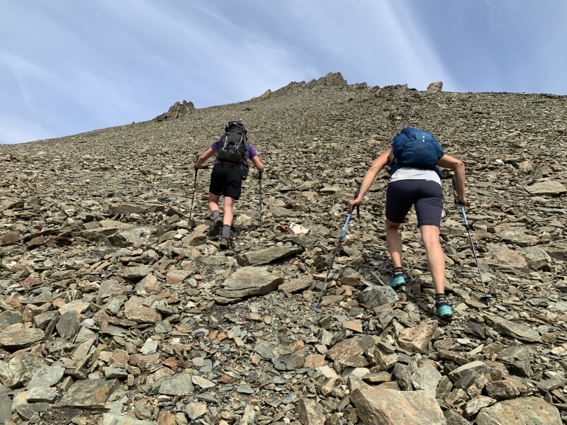
Two steps forward, one step back. This section requires patience.
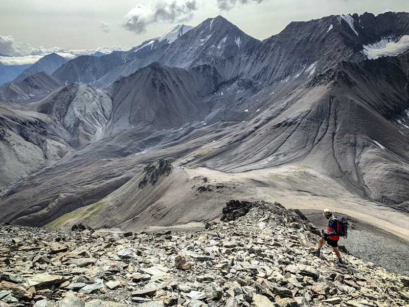
Just below the summit, the views are stunning.
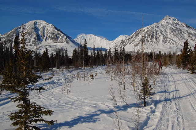
Skiing up the the path beside the creek. Mt. Decoeli in the background.
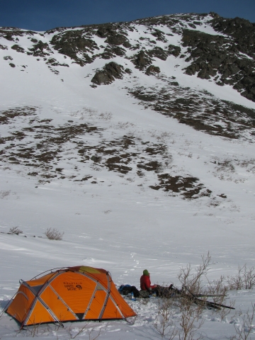
Camping at the rock glacier.
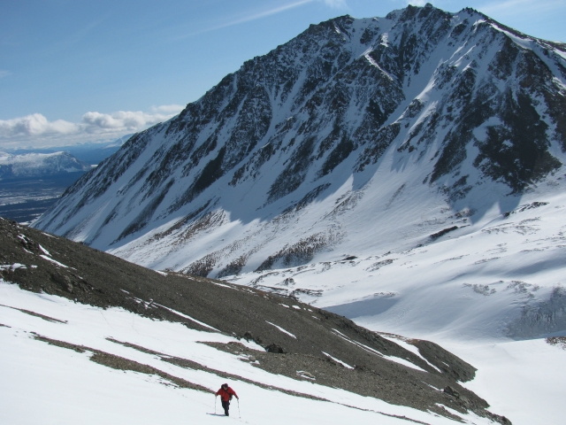
Hiking up the side of Mt. Decoeli.
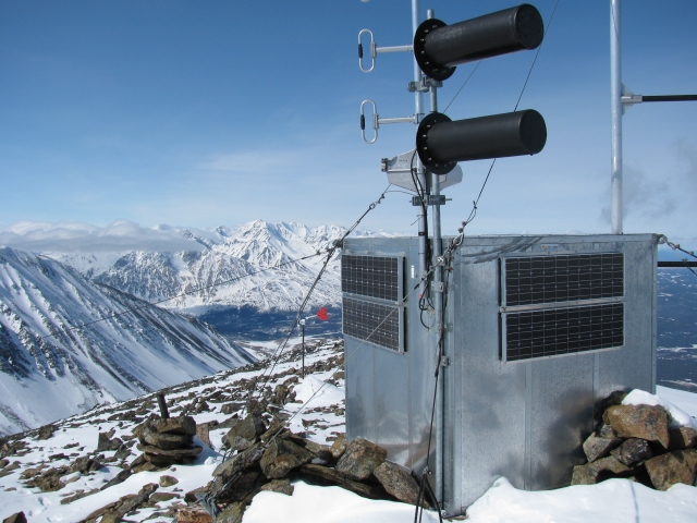
The radio tower on the summit.
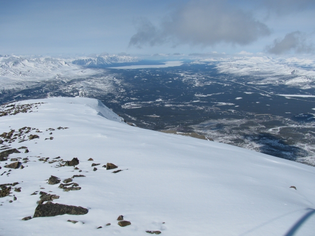
The view of Kluane Lake to the north.
Looking down towards the creek and the trail from the summit.
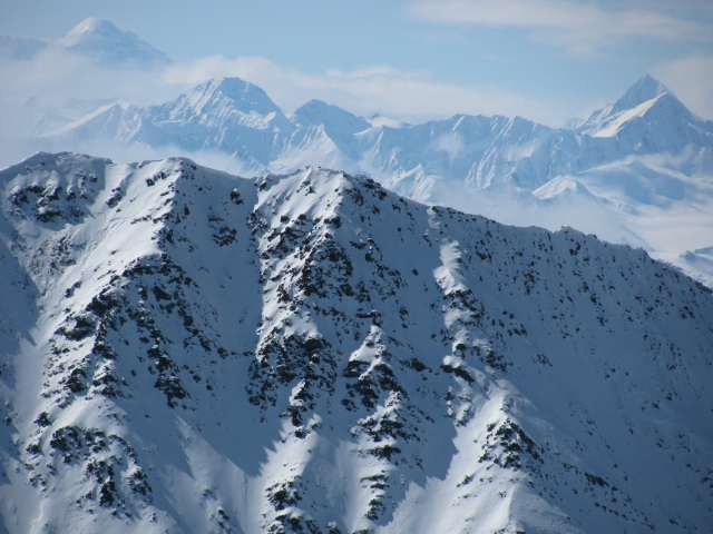
On a clear day, you can see the icefields. If you're lucky, you might even see Mt. Logan.
Hiking down the ridge.
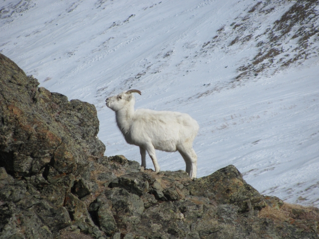
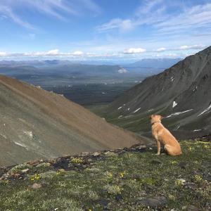
Bring binoculars to view sheep on the trail.

Chris Kenny August 18, 2025
Went last week. Trail is easy with a lot of large rocks until the final 1.5 km climb. This is where this trail earns its hard rating. We felt like we could’ve used ropes at certain points. Very steep and a lot of shale. Great view but may not be worth it if you have little experience.
Yukon Hiking November 15, 2024
We snowshoed a portion of the trail up to where it joins the main creek (November 9th). The trail had been packed down slightly by a snowmobile and skier tracks. The creek had some open water still, as it hasn't been too cold, but you can likely continue further into the alpine easily avoiding these areas.
Sheila L. August 17, 2024
Just did this today for the second time. The first one was 2 years ago and didn’t summit coz we took the easy- look left side of the mountain and ended up 2/3 of the way then realized it was not safe and close to impossible, so we retreated. No way this hike can be done in 6.5 hrs unless you’re running for part of it and not stopping to absorb the view. But at the top it was gorgeous. Got to see Mt. Logan as it was a clear day.
Norm Bastien August 6, 2024
This was the first mountain I ever climbed. I was 15 years old. I rode my bicycle from home (Haines Junction) to Bear Creek summit and started up the creek at about 10AM. I managed to summit about 3PM. Guess what I saw on the other side....MORE MOUNTAINS!! The views were spectacular (and I never owned a camera). I got back to the bicycle at the side of the road about 7:30PM (came across a Griz with 2 cubs not far above the treeline but they were at a respectable distance so I waited until they had disappeared) and after a rest, headed back home. The downhill was the easiest part of the trip, almost downhill all the way. My Mom & Dad were getting a bit worried because I never told them where I was going. Young and stupid. I never left again without telling them where I was going. That summer I topped 3 more mountains in the range(1 with my trusty and pregnant dog who decided to lay down just above tree line while I topped that day's climb, then when we got home, she had her babies). That was the best summer of all summers. I also started training for the planned 65 mile foot race from Haines Junction to Destruction Bay but it never materialized. I was up at 6 AM, had breakfast and ran to Pine Lake Campground and home every day before school and continued the exercising through the summer. Oh to be young again but Jean and I are still active thanks to our wilderness living in the Yukon.
AB June 29, 2023
Hiked this June 28, 2023. Amazing hike! Wildflowers were blooming all over the meadow, there was a large group of sheep grazing on the grass that we were easily able to go around. The winds were very strong as we got closer to the peak, so the scramble up was tough but totally worth it for the views. Took us 8h 15m total (including 3 snack breaks and time admiring the sheep). Strava clocked my distance as 17km round trip. I didn’t bring my dog because of the amount of scree and I’m glad; many rocks were sharp, many slid out from under you as you climbed and it was easy to lose your balance and slip, especially with the winds
- a pulled muscle or paw pad cut waiting to happen for my dog!
Amber September 26, 2022
Hiked this yesterday with a friend and my 3 year old lab/husky. I was unsure if I should bring him because he has had a bit of trouble with his paw pads in rocky terrain before. After reading other peoples comments and chatting with friends I decided to give it a try. Because so much of this hike is walking on rocks he did wind up wearing his pads and had some bleeding. Nothing major but if I were to go again I would leave him home. Just thought I’d mention this in case anyone else has a dog with similar issues and is on the fence about bringing them.
Birkenstock Bel September 4, 2022
Bagged this puppy in my Birks on August 28, 2022, a feat I’ll be bragging about until I die. That being said, as wonderful as bragging rights are (and the $100 I secured as a result of this bet), they are not worth a fateful slip or perilous injury to the exposed and tragically unsupported foot and ankle region. This is a tough hike; wear your hiking boots, bring poles, and be aware that the “not particularly fun” talus slopes are loose scree easily triggered into rock slides. If you’re with friends who regularly spout out obnoxious platitudes like “when there’s a will, there’s a way” and “when life gets tough, the tough get going”, don’t bet them to do stupid things, like bag a peak in Birks. Because they will actually do it. And when you bag this puppy too, always remember you aren’t quite as badass as Birkenstock Bel, but at least you are alive and likely a lot more comfortable south of the knee region than her. Happy hiking!
Tom August 9, 2022
Hiked 22 July 22.
Incredible hike, with amazing views. By my GPS it was closer to 18km, and it took us 7 hours, not including lunch. Where the creek is impassable there are trails through the brush. It's also possible to avoid going through the brush by hopping back and forth over the creek, water levels permitting.
Meredith Barley August 3, 2021
Hiked with my dog 2 days ago. What an amazing place! Long slog up the riverbed before the actual climb but the vistas are spectacular. Attempted to hike back via the south ridge of the creek. Not really recommendable, no easier going than the river bed and TONS of blueberries which made me a bit bear ancy. $50 reward to anyone who finds a pair of black diamond Z-poles that I lost on that riverside ridge (have been all over the world with me...sentimental value..)!
Cam May 31, 2021
Tried Decoeli yesterday and almost made it all the way to the summit! Still too much snow to make it all the way but we hiked to 2000 meters on a subsidiary peak.
Had to snowshoe to the base of the mountain. Once we started climbing, most of the slope was clear but about mid way we had to use crampons and mountaineering axes. The views were amazing. Intervals of strong wind followed by complete silence with no wind at all. Saw some bear scat, some marmots, and some sheep in the distance.
Total of 9 hours return trip.
KP June 21, 2020
Hiked Decoeli on June 20th. One of my favorite Yukon hikes so far, real gorgeous views from the top and a challenge to get up there (and down). On the descent, saw some Dall sheep feeding on grassy sections of the range's slopes. Bear scat early in the trail but no further signs.
The brush is very dense next to the creek, especially as you get closer to the rock glacier, which makes the going quite slow when you have to dodge into it. The scree as mentioned makes the ascent and descent considerable work as well. The scree is of mixed sizes which makes the descent a combination of climbing, hiking, and scree sliding.
JN June 25, 2019
We hike Decoeli on June 25. We saw some marmots but no signs of bears either.
It's quite steep to hike the mountain, some parts are more climbing than hiking, but soo worth it. :) The view is amazing !
Very easy to find, from the yellow gate the path on the left and then the creeks. Just need to watch for it on the way back!
Took us 8 hours in total with the long lunch break on top
Maya June 18, 2019
Hiked Decoeli on June 16th 2019 with my 1-year old Australian Shepherd. He loved it! Lots of wind and clouds, so unfortunately no view towards the ice fields. I saw few sheep on the way up. I started at the yellow gate: the trails (it is actually a small dirt road) starts just left of the gate and is very clear until it gets to the creek. It took me 3 hours to go up and 2:45 to go down.
JM June 17, 2019
Did this hike this weekend, June 15-16. We hiked to the rock glacier and stayed overnight at the base before making our way to the summit the next day (there is a nice grassy nook on the right side of the river that is fairly sheltered to pitch a tent). Trail conditions were great. Although only the winter route is recorded on this site, it is quite nice to do in the summer. The hike up to the rock glacier along the river bed may call for some stream crossings (mid-calf at its deepest this time of year) or bush whacking. However, tempting it may be to hike up the small hill on the side of the riverbed I would not recommend it – walking through the brush is slow. Once at the rock glacier on the right side of the river bed there is a cairn and flagging tape indicating where to head up to the summit of Decoli. This weekend it was extremely windy (but maybe it is always windy?) heading up on the right side of the mountain helped us to avoid some of the worst gusts of wind. Beautiful view at the top. Highly recommended. Did not see the caribou carcass that the person a month ago saw a grizzly eating, but best to be careful anyways in bear country.
Emma May 20, 2019
There is large grizzly eating a fresh dead caribou on the north slope bench right below Mount Decoeli. It was curious and came within 100 meters of our tent. Keep an eye out for it.
Cata July 26, 2018
Hiked this today with my dog. Beautiful day and amazing views, saw Mt. Logan from the top. Some bushwacking by the creek on the way up, on the way down I decided to avoid that and just cross the creek when needed, it was so hot that it didn't matter getting a bit wet. From the rock glacier and up I picked my own way, heading up the front face to the top, I don't really recommended that way lol, going around a little further would have been a lot easier. Saw a few Sheep up in the ridge and by the scree slope.
7 hours roundtrip.
Dwight July 8, 2017
Hiked July 5, 2017. Didn't see the trail head 20m south of the pull out, and just started out of the pullout with a 1km bushwack till the creek opens up. walked up creek bed until the glacier. Once on glacier walk as far up the glacier as possible and aproach the summit from the back. We aproached the summit from the front and ended up doing some climbing which was exiting and fun but not for your typical hiker. On the way down we flagged the trail with pink flagging tape once we hit tree level to help find the trail more easy.
Started at 1130 and summited at 1430 at back at car around 1700.
Ps. pullout is 20km NW from Haines Junction and you can either start at the quarry with a yellow gate 100m south of the pullout at the road going left at the quarry gate or the ATV trail 20m south of the pullout. they both meet up after a couple 100 meters anyways.
A Alt July 7, 2017
Hiked Mt. Decoeli on July 2, 2017. The trail along the creek is incredibly overgrown with thick willows and alders, which was a battle to get through so we moved off to the left onto the plateau until we reached the rock glacier, which made walking much easier than scrambling over and around and under the overgrown bush. On the way back down we managed to walk along the sides of the creek which sure made it a lot easier walking! It took us about 4 hours to make our way up the creek/through the Garden of Flowers Meadow/Plateau, up the rock glacier, and finally up to the ridge. We didn't quite get to the summit (would probably have been another 45min to the top and we had a late start). The view from the ridge was great! We could see all the way to Slims and towards Haines Junction as well. The way back was a bit faster (just under 3 hours) thanks to the big patches of snow between the rock glacier and the ridge, which we used to slide down :-) Saw lots of thinhorn sheep. I was with someone who has hiked this numerous times, and she recommended walking as far back into the valley as possible and then heading up to the ridge, rather than the recommended route over the scree, which is not very stable. It definitely ended up being a good choice. We'll be back!
Jo September 5, 2016
Went up Decoeli on Sunday Sept.4th. I went up the grassy slope after reaching the base of the rock glacier and crossed the next creek before working my way up snow slope between a rocky outcrop and the end of the S ridge of Decoelie. The S ridge slope was rock hard and I had to kick step hard to make it up to the top. Probably would've been better a little an hour or so later but there were signs of snowballing and rockfall from the previous warm afternoon. The Parks Canada route description offer yet another alternative and recommends going back into Summit creek after you cross the creek at the end of the grassy slope , then around the rock outcrop and up the next drainage over. I decided to take a look at that option on the way down, went to the pass and down the drainage behind the rock outcrop. I then traversed to rock glacier trying to stay level with the drainage across the valley towards unnamed peak. I thought the GPS route for that peak is a bit too agressive and hiking up the drainage proper was very smooth. You can then head for the SW slopes before the pass. Once on the first summit, I continued along the ridge pass 2 other sub-summits before making it to the last and highest summit (451462). From that last summit, I walked N along the ridge to recon a direct descent and went for the NW gully immediately down from the summit back towards Summit creek. You can actually see the creek from that drainage meeting up with Summit creek 100m or so down from the rock glacier all the way from the top. The top 1\3 of the gully was firm cold snow and made for supportive but the gully being in the shade, the steep scree was like cement after that. I tried heading across the gully for a sunny spot and the scree was indeed much better\softer there and all the way down back into Summit creek. Really fun day circumnavigating this valley with awesome views, including Logan, from the summit of Decoeli.
Marc May 23, 2016
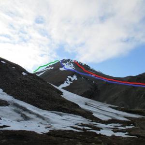
Hiked this mountain on May 22nd, 2016. There is not a sign for Bear Creek Summit so count your KMs. From the pullout, the trail is marked with an orange ribbon. From there, follow the trail in the forest for about 1 KM. Once you get to the creek, the trail disappears. Just follow the creek until you get to the rock glacier. We had to cross the creek several times, but our feet never got wet. At the rock glacier, Mount Decoeli is the mountain on your right (the big one). My friend hiked along the left ridge of the mountain (in blue). I just hiked straight up where the boulders are close to the summit (in red). There's no trail, so pick the route that you like and go for it! On the way down, we went around the other side of the mountain (in green). From there, we followed the valley and ended up back on the rock glacier where we had first went up. It ended up being a 18 KM loop.
Jan Triska August 3, 2015
Photo appended, from July 19th.
Jan Triska August 3, 2015
This is an outstanding day-long scramble, if you don't mind a slightly difficult access. The route up the Bear Creek was slow; either the boulder creek bed or the occasional bushwhack through creeping alders. Vintage Yukon, I say.
Once on the shoulder of the actual mountain, a straightforward ascent line (given the clear weather) and also a lot of work for the legs. The scree here is fairly unstable, it rolls while on the way up and on the way down. I found myself steering towards the fin-shaped rock ridges in the summit part, just to get some solid rock, with footholds and handholds, instead of the tedious scree. Fantastic summit vies.
7 hrs up and back.
Vi August 19, 2013
If there was the trail along the creek, it has been washed out for pretty much all the way up to the rock glacier. We had to follow the creek bed and cross the creek several times.
