Total Distance: 8 km
Return Time: 6.5 hours
Elevation Gain: 1272 m
Difficulty: Difficult
Region: Carcross
Traditional Territory: CTFN
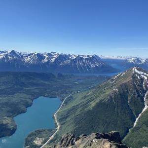
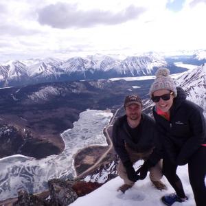
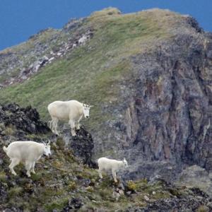
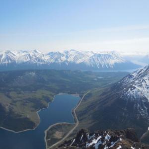
Dail Peak, named after miner George Dail, offers sweeping views down the Klondike Highway above Windy Arm of Tagish Lake. It is connected via a ridge system to Mount Matheson and eventually to Montana Mountain. It is the home of numerous Dall sheep and mountain goats. From the top of the ridge, there are tremendous views of the surrounding area.
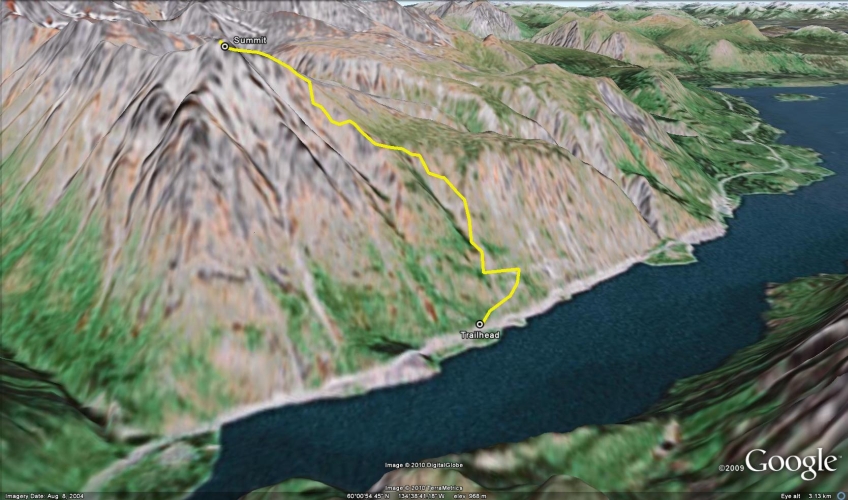
From Carcross, continue on the South Klondike Highway towards Skagway, Alaska. After 25 km past the community of Carcross, there is a pullout on the right side of the highway with a yellow gate and a road that leads up the mountain side. Park at the pullout with the yellow gate.
Start up the old mining road and skirt around the yellow gate. Follow the road as it climbs parallel to the highway. At the first fork in the road, where going straight would descend, take the left fork uphill. You will soon come to some mining relics and a small clearing. Walk straight to the very end of the clearing where a less established trail contours uphill.
Follow the rough trail, which may have pipes and tubing running towards the gully. The trail stops at the gully. Make your way uphill from here along the goat trail along the ridge. You will follow this ridge for quite a ways up.
Shortly you will come to a small rock face on the ridge which you can either climb straight up or skirt around the right side. You will pass through some stunted trees which should have goat paths leading through them. Higher up, look for a somewhat worn goat trail that will cut across your trail. Follow this goat trail to the left (south) as it heads towards Dail Peak. At any time now, pick your way up the open hillside to the top of the ridge. At the top of the ridge, you will overlook a high plateau which is connected to Montana Mountain.
Make your way to the left (south) up to the rocky section which will feel like a small false summit. From here, continue along the ridge to the base of Dail Peak. The ridge is broad and has some gnarly rock formations on the east side (your left). It is a short hike up to the summit from here.
Follow the same route back. Do not be tempted to descend any different gullies, many of them end in sheer cliffs and waterfalls.
The start of the trail along the mining road.

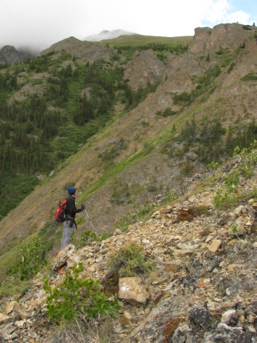
After the mining camp, follow a trail to the gulley and then climb upwards.
Misty peaks in the distance.
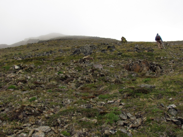
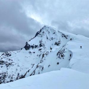
Following the goat trail towards the misty Dail Peak.

Knit a sweater while taking your lunch break.
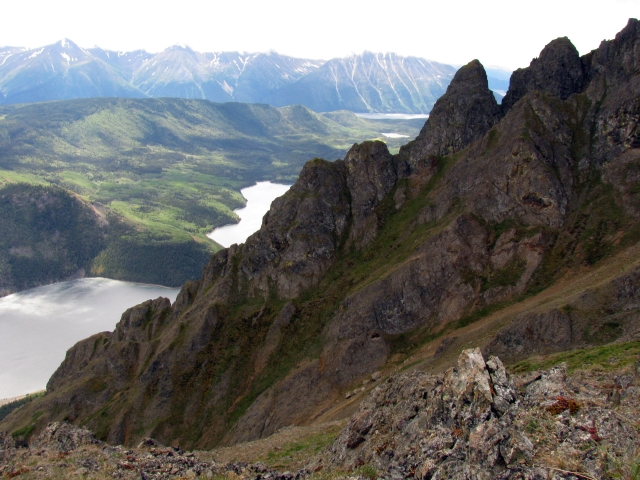
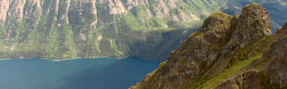
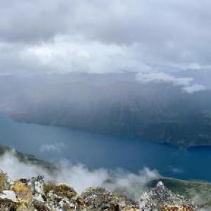
Rocky pinnacles above Windy Arm of Tagish Lake.
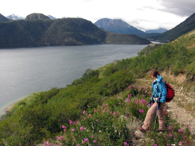
Walking up the grassy slope towards the top of the ridge.
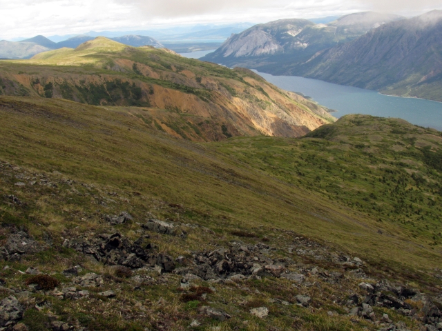
The view to the east from the top of the ridge.
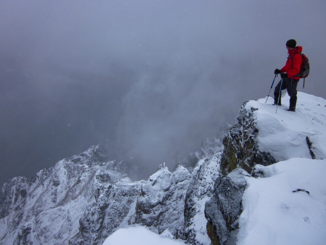
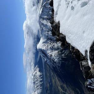
Looking down over knarly rock pinnacles from a snowy summit.

Descending down the broad ridge. Look over the right edge to see more rock pinnacles.

Do not follow these tempting shortcut gulleys back to the highway.

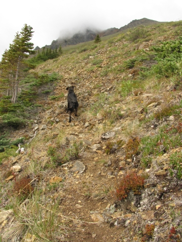
There are plenty of goats and sheep on the trail.
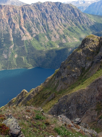
Windy Arm and the White Range.
Liz B August 31, 2024
My partner and I hiked Dail Peak on August 30th. As everyone else has said, the initial climb up the face is incredibly steep, hiking poles on the way up and down definitely saved my legs. As we got closer to the top of the face, we headed towards the right and mostly avoided the treed area. There's a small clearing, with a noticeable patch of dead trees, where the ATV trail begins. We followed this trail around the backside of Dail Peak, all the way to the bottom of the ridge and hiked up to the summit from there. The trail adds about 4kms to your total distance but it's easy walking and a nice break from the relentless incline. You also get great views of Montana Mountain from the backside.
We saw lots of wildlife including mountain goats, marmots, ptarmigan and even a golden eagle.
Our stats were: 12.23kms distance, 1239m elevation gain, 3.5 hours up and 2.5 hours down. I included our GPS track to show where the ATV trail takes you.

DACVAN August 8, 2024
Thank you to yukonhiking.com and all of the commenters below. This was an incredible hike. Very vertical and very difficult, but all worth it. Bring lots of water: nothing up there on today‘s hike. I may have gone the wrong way across the main gully (although I was following a clear trail): handholds on gully crossing are very crumbly: be careful. For the ascent, I generally followed this described route. For the descent, I followed an old mining road that you will see in the basin north of the peak, from the peak. This gets you past the gully. Saw some goats along this way, as well, as a bonus.
Slim Shady July 21, 2024
Epic hike with exceptional views the entire way! At times it was difficult to find the trail, particularly on the way down, and it can get very slippery & sketchy. We saw lots of sheep & goats in the distance. On the path that we took, we didn't come across any water sources. You would have to go down into the valley to access water if needed. Great weather, no bugs, no signs of bears. Highly recommend this special hike!
CM July 12, 2024
Hike completed on July 7th. Extremely hot weather made it quite the adventure. Both of us had to stock up on water once we hit the creek at the top of the mountain (we always carry a water purifier on day hikes and it paid off on this hike!) I have to say, this hike was unexpectedly amazing!! The terrain was more technical then expected due to the gradient and fine dust/tiny rocks on trail, mountain goats everywhere, impressive elevation gain, huge rocky pinnacles sounding the summit, and a nice view into the surrounding lakes and mountains. It also connects to Montana Mountain so you can do a loop if you want. This hike is a gem!
Hannah July 2, 2024
Hiked June 30. Very steep up from the highway with loose rocks. There is an ATV trail once you get to the plateau that adds a bit of distance but is easy to follow and goes to the summit. Once up on the plateau it is easy walking and the summit is very achievable. Going down the steep scree back to the road was challenging but do-able. Beautiful hike with great views right from the start!
Chris May 26, 2024
Attempt on 26May, had to turn around as I lost the trail. Snow looked minimal however. I did not hike with poles and regretted it, this is one of the steepest slopes one can reasonably walk up. I would recommend getting the trail on GPS to follow, otherwise it's all too easy to end up somewhere lost on the slope.
Maxime Bachelot - @2MarmosetsAutourDuMonde January 7, 2023
wonderful hike. did it in july 2021 and will not regret the beautiful day all alone with no one around but mountain goats. pretty steep at some stages but definitely worth it.
AW August 22, 2022
Attempted to hike this on August 7th. Not sure if we followed the right goat path (or the easiest path up) but it was super steep and lots of loose rock. We didn't have hiking poles which obviously made it more challenging- and we were basically butt sliding the whole way down until we reached that small plateau near the beginning where the gully and piping/tubing is. I think we hiked about 3k one way until we reached a point where it seemed way too steep and sketchy. Even though we didn't summit and were terrified the whole time, the views were amazing
Clara September 7, 2021
I haven't done this hike, but have heard that the Venus Mine site near the bottom of this hike is contaminated with high levels of arsenic. I don't think it has a big effect on the Dail Peak hike, but is something to be aware of.
Aljaz August 15, 2021
Did this hike in October 2020, spectacular! Short but steep! Might be a little tricky to find the way up, I somehow made it to the top with no major issues. There was snow on the top, not a problem. I made a video about my hike, you might find it useful to find the way to the top - https://www.youtube.com/watch?v=aSZDYcJH2y4&t=58s
Enjoy the hike and be safe!
Teamstrong June 5, 2021
We hiked this on June 2nd, there were still lots of snow. It was sunny and the snow was starting to melt. It made the hike so much harder. Several times we got stuck in the snow even with snowshoes. But overall the view i think is so much nicer. The 360 view at the peak is so worth this hike.
Marianna May 29, 2021
Epic hike to the Dail Peak summit yesterday, May 28, 2021. Very difficult, physically demanding 11 hours hard work, conditions were challenging, strong wind and lots of snow but nothing could stop us. After all the snow we had this past winter, it is still full on winter up in the higher section, but even below, all way up big section of deep snow. The first steep section of the goat trail is good, very quickly there is a gorgeous view, easy to avoid the snow but higher up it would be hard to find the trail and impossible to avoid the snow. We didn’t have snowshoes but had gaiters on. We avoided the gully to the left on the way up and went right, to do a little loop and approached the summit via the ridge from the right. Long way up on the snow, very steep, some slippery section, blowing fresh and hard snow. The weather turned much worse when we reached the summit but still the view was absolutely breathtaking. On the way back we explored the area towards the old Venus mine, checked out the old cabin on the hill and descended in the steep gully where we had one of the avalanches this past winter. Reached the road around 10:15 pm. It really felt like a huge accomplishment. ☺️
Sam August 2, 2020
Sunday solo summit - saw 3 groups of hikers who chose not to summit today as they couldn’t find the trail. I continued on and didn’t have any issue, intersecting the ATV trail like other commenters have said below, is a far better route than what is shown on the map here. Epic hike, incredible views! 10/10.
Virginia June 28, 2020
Did this hike today! Epic, beautiful! We used the GPS a lot to find our way because there is no official trail pretty quick. With more people using the trail, it is getting eroded and there is more loose rocks on steep slopes, so just take your time. View from the ridge in the Alpine is increadible! Took us 4h50 min for 9.89 km including breaks and we are in pretty good shape.
Kyle May 10, 2020
Great epic hike, harder this time of year in the snow though. Took us 7.5 hours total with a rest at the summit.
Advice in the comments are very accurate.

Kyle May 7, 2020
Difficult hike in the snow, took 7 hours but well worth it.
Hernan Ugalde June 24, 2019
Attempted this on Friday, but wasn't that keen on the dry and loose gravel up just after the trees, so decided to go back. If someone has a GPS track that would help for next time, thanks!
Andrew April 4, 2018
Brittni... In response to your question.... AB Trail is longer and is steep in spots, but it is a well-maintained trail that's hard to lost...
Dail Peak is not maintained. The first half of the trail is very steep, and you're hiking mostly on goat trails. When dry, the gravel can be loose, and when wet it can be slippery. It's also easy to get lost on the trail when heading back down, so I recommend using your phone GPS to map a route as you hike up so that you can find your way back down if you lose your path.
Both are great hikes.
Brittni September 4, 2017
Can anyone that has done the AB mountain hike in Skagway AK compare it to this one? Thanks!
Tyler Deemer July 27, 2017
Anyone know of established climbing routes on dail peak??
Cheers mates
Anthony May 8, 2017
Hiked this route on Sunday, May 7. Intermittent snow patches at higher elevations with a mixed bag of snow conditions. The summit ridge was fully snow covered and basically perfect conditions. 5 hours return trip.
Jo September 18, 2016
Hiked Dail peak today. There's construction on the highway on the section where you would usually park so I had to backtrack east and park in a pullout near the bottom of Pooly canyon around UTM 521616 6654615. I would recommend scrambling up right away above the cliffs that border the road to try to meet the old road as early as you can, just climb high enough that you don't expose yourself to the cliffs and keep traversing SW at about 720m. The road makes for fast and easy travel. Once you get to the old mining ops, go up and follow the ridge, avoiding difficulties on the right. The track on the website is a bit too far west. You do want to follow the ridge just to the right of the drainage but then you also want to hit the ATV track as early as you can as this will also make the hiking easier and faster. The track can be found near UTM 520118 6654200 at about 1320m. Follow this track up until you can see it doing a 180 degree turn around a drainage and follows and start hiking up the ridge from there. The way to the summit following the ridge is obvious and doesn't feel exposed. You could also walk up the drainage from the turn in the ATV track and take a left up the ridge from the saddle. I prefer the ridge both ways for the views. Clouds closed in on me in the summit and I decided to wait it out for about an hour to try to get the views. Definitely a spectacular viewpoint of tagish and tutshi.
Andrew July 18, 2016
Amazing hike. The most rewarding I've done in the Yukon, and also the most physically demanding. The advice from Marc (below) was excellent, as intersecting the ATV trail provided a welcome respite to the very steep first half of the hike.
There is a cairn that marks the ideal entry point into the wooded area, which is just above the sheep trail that cuts south mentioned in the main description. This can be helpful if you choose the steeper route because it's easy to miss that sheep trail when ascending.
Plenty of goats and sheep at the top. I am curious where that ATV trail ends up. Highly recommended trail, but it's not easy or for anyone afraid of sheer heights.
Marc June 25, 2016
This was definitely the most challenging hike so far, but the most rewarding. I parked at the yellow gate (precisely 23.5 km after the Carcross bridge) at 9 am and was back at 3:30 pm after spending 1 hour on the summit.
The trail described here was really accurate. You follow the defined old mining road for the first part and then you'll get to an obvious clearing. There's old mining stuff sitting around here. Make your way threw the clearing and the trail will start again (being less defined). From here, you make your way up the ridge for a LONG way. It is STEEP. There's not really a trail bringing you to the top, but you eventually figure it out by following the sheep trails. At a few spots, there'll be rocky sections and you can go around them to the right or you can just hike threw them if you want.
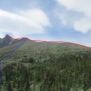
Keep climbing up the ridge. There will always be the valley (or gulley) to your left. I never saw a trail intersecting my trail towards the left on my way up like described on here. However, I did see it on my way back down and it is shown here (the blue line). I don't see how taking this sheep trail is a good idea. I just made it all the way up the ridge until you reenter a forest area (you'll see the trees start to become taller again). This is where I took the picture. There are a few cairns to help you make your way in this dense forest area. At that point, stick to the right and you'll fall on an ATV trail (the red line) and you can follow it until you get to the base of the summit. It might add a little bit of distance, but you'll be happy to walk on a legit trail for the last bit. From there, just pick a spot and make your way up to the summit. Highly recommended.
Fraser July 12, 2015
Awesome hike. No one has mentioned this, but as you climb up the ridge and get through the steepest parts (about 60% of the way up) there is an ATV trail. The trail swings wide to the right (north) but eventually can be followed towards the peak. It added a little bit of time to the hike but saved some stress on my legs.
Kylie and Drew May 21, 2015
Hiked to summit on May 16 2015. Tough but hugely rewarding hike. Awesome 360 views from the top. About half way up we decided to bushwhack south through a gully and approach the summit from the east, avoiding the snow on the main north/south ridge. Solid snow pack at higher elevation. We chose to walk the north/south ridge on our descent and had a tough time holing through waist deep snow. Challenging to find your original trail on the way down so again we were forced to bushwhack through shrubs, snow and small pines. Saw a few goats at lower elevation.
5.5 hours up and about 3 hours down in tough conditions.
Highly recommended!
Joel, Chris, Rob May 10, 2015
Hiked to summit May 9th 2015, Great hike with amazing views! Goats seen. Snow pack strong on ridge, post holing at lower elevations.
JP August 7, 2014
Easily my favourite hike of the summer 2014 (So far)!
Few points:
- Bring A LOT of water in the summer.
- It is easy to get "lost" on the way back. Finding the trail on the way up is easy, but on the way down, it is easy to get confuse and choose the wrong slope...
The view on the top is breathtaking. A full 360 degree panorama of beauty will unroll just before your eyes.
I would say that an average hiker with a light day pack can do it in 5 hours round-trip. With a loaded backpack, it took me 5 hours way up and 2h30 way down.
It *is* a hard hike.
*Must* have good ankle support boots.
Bring lots of water.
Highly recommended.
Marko Marjanovic October 8, 2011
The snowline was at the top of the plateau today, just before the top ridge. Snow pockets were up to 12 inches deep, but the average snow depth was only a couple of inches. There were a lot of goats on the surrounding ridges.
