Total Distance: 15 km
Return Time: 4.5 hours
Elevation Gain: 367 m
Difficulty: Easy
Region: Kluane
Traditional Territory: CAFN
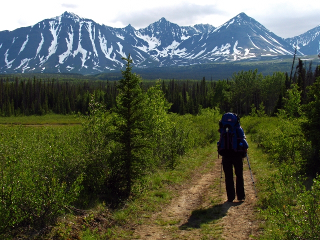
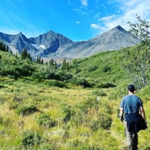
The Auriol Trail is close to Haines Junction and is a popular day and beginner overnight hike. The actual trail itself does not go above tree level, but an extended hike from the trail into the alpine is highly recommended. Add 5 km and 430 m elevation gain if you hike into the alpine.
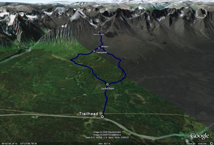
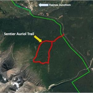
From Haines Junction, drive south on the Haines Road, towards Haines, Alaska for about 5 km. There will be a sign indicating the Auriol Trail turnoff is 2 km away. Continue for 2 km and park in the pull-out on the right. There is a sign at the pull-out with a map of the trail.
Note: This hike can be completed as a day hike, but is a great overnight destination as well. Parks Canada requires registration for any backcountry overnight trips in the park.
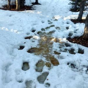
The trail starts by crossing a small clearing and then stays in the trees for the most part. It is well-used and hard to miss.
The trail climbs gently through a mix of poplar, spruce, and pine forest. You will reach a junction in the trail after 2 km. Both trails lead to the campground, with the left fork taking a more gradual route, while the right fork is 500 m shorter but with more ups and downs. We typically suggest taking the left fork and then making a loop and returning via the other fork. If you take the left fork, after a while the trail will pass by a small lake and meet up with Auriol Creek.
After about 7.5 km, or halfway, there is a small campsite with 4 tent pads, a fire pit, an outhouse, and a place to hang your food (out of the reach of bears). Auriol Creek runs right by the campground, so there is plenty of water.
If you are not planning on exploring into the alpine, then continue on the trail to complete the loop. Once again you will pass through a nice mix of forests on the way back to the trailhead.
If you are going to head into the alpine for an extended hike (add 5 km distance and 430 m elevation gain), from the campground continue 500 m west on the trail until you come to a bridge. This is the best point to head southwest towards the mountains and the alpine. Follow the small creek, crossing it ever so often in order to pick your way up towards the Auriol bowl. You will have to climb one of the steep moraines that run by the creek. Pick the one with the least amount of brush on its top.
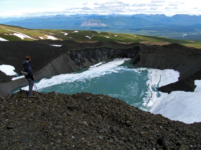
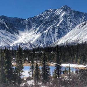
From the top of the moraines, you can easily hike towards the bowl. There is a beautiful teal-coloured alpine lake at the base of the bowl. Be careful not to get too close to the lake, as the rock covered ice around it is highly volatile and ever-crumbling into the lake. After you've explored the alpine, make your way back to the bridge and continue to follow the trail as it makes a loop.
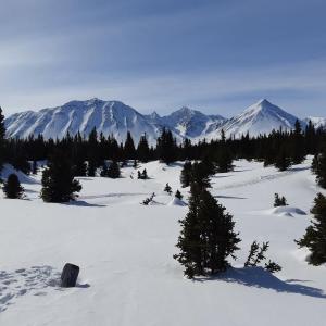
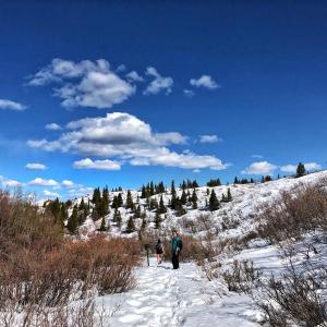
Auriol Trail is a four season trail and you can ski, walk, or snowshoe it. The trail is often groomed by Parks Canada staff for skiing on the clockwise (left) section of the loop up to about 4.5 km (9 km round trip). Check ''Parks Canada Yukon'' on Facebook for updates. Expect to break trail for the remainder of the route, and depending on any fresh snowfall, add additional hours to the trip.
The left fork takes a more gradual route with no avalanche risks, while the right fork is 500 m shorter with more ups and downs and there is a gully towards the alpine near the top end of the loop. The gully would be considered a terrain trap, so practice caution depending on conditions.
Skis or snowshoes are recommended for ease of movement, unless the trail is hard packed and solid enough for walking (though you won''t know unless you try or have seen a trip report from other useres). As with any groomed and track-set trails, avoid walking on the ski tracks.
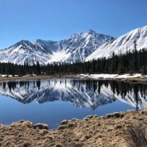
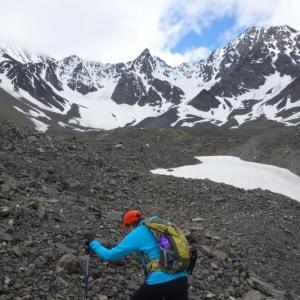
The start of the trail through the clearing. In the background is the Auriol bowl.
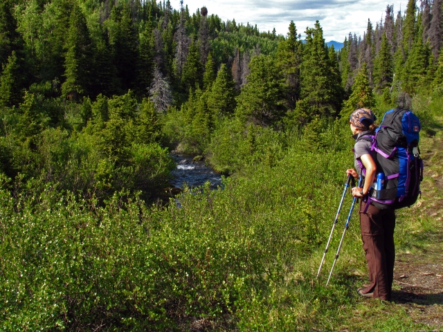
The trail soon follows alongside Auriol Creek.
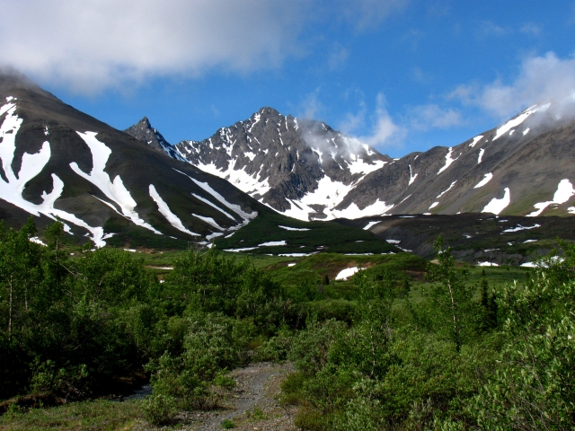
The view of Auriol bowl from the campsite.
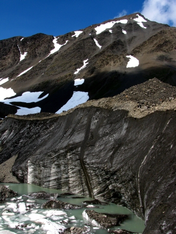
Looking down at the winding morraines.
The alpine lake is surrounded by rock covered ice which continually crumbles into the lake.
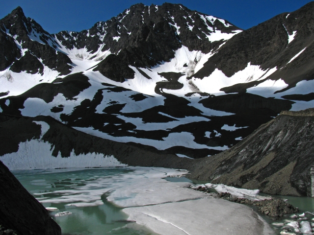
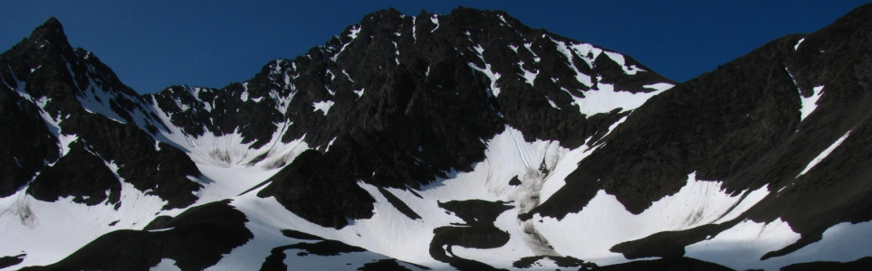
A view of Auriol bowl and the alpine lake.
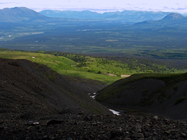
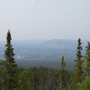
The view down towards Haines Junction.
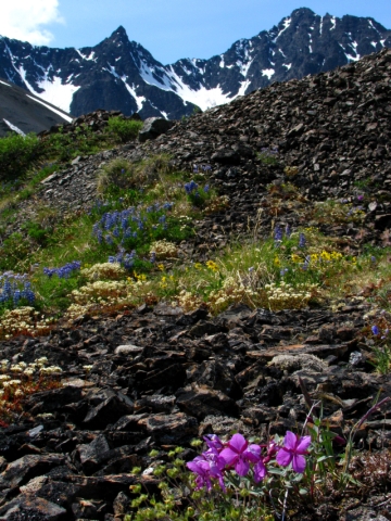
Wildflowers abound in the alpine.

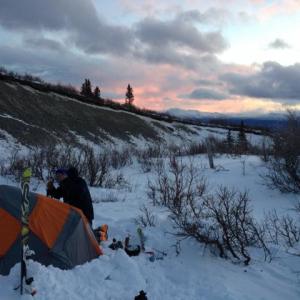
Sunshine is very brief in the winter in the shadow of these mountains.
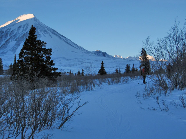
The peaks of the Auriol Range, topped with sunshine.
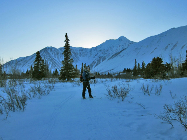
Skiing is a great way to explore the Auriol Trail in the winter.
The Local Wildlife June 22, 2026
All of the bug spray in the world couldn’t save us from the hungry mosquitos on June 20. Highly recommend Deep Woods spray, long light layers and perhaps bug jackets.

Martin November 23, 2025
November 22nd, broke trail on skis all the way to the campgroud via the left loop. Deep snow all the way through, bring skins and floaty skis if you're aiming for the top.
The right loop had a packed trail beyond the 2km post; I didn't check how far it went past the post, but it didn't reach the campground.
Proper type 2.5 fun, lovely views!
Melissa October 11, 2025
October 11: tiny bit of snow on some part of the trail. Fresh Grizzly tracks from I’d say max 48h but maybe less about 3km from the start of the trail and clockwise. Huge bear scatt which makes me think he must be a really big one. We made lots of noise on the way up. Didn’t see anything more than lots of tracks. The sky was clear and the view was beautiful at the top.

Lily September 3, 2025
Absolutely gorgeous hike, very easy, trail is easy to see and follow, no signs of bear activity or reported sightings lately, the bridges to cross the creeks are all very well maintained.... Infact the trail is so easy that you might get a little over confident and stop paying attention to your footing then end up in the emergency room. Be very careful where you step once you get passed the wooded area and into the more marshy willowy area between kms 5-7, there are some very well hidden holes and crevices that swallow ankles. Was still worth it though!

Nissa June 27, 2025
June 26th: Spent 1 night at the backcountry campground. The creek is flowing, plenty of water. 4 gravel tent pads, firepit, outhouse. The hike itself is underwhelming, but good introductory backpacking trip. Lots of moose poop, no scat or signs of bears. Bugs were brutal in the morning.

Dev June 4, 2025
Spent a (windy) night in the campground. Minimal snow only close to the alpine at the end of the trail. Note that there is no water right where the campsite is. The river bed is dry and spring seems to be late. Make sure if you’re staying at the campground to bring lots of water. Not much foliage or flowers!

Kay May 16, 2025
The trail is still almost comically snowy - the snow supports you in the early part of the day, but as it warms up, you post hole to hip height in places. We made it into the campsite (taking the loop clockwise) with lots of laughs, but ended up coming out the same way.
It was slow going and there were very wet feet at the end. Currently a type 2 fun misadventure!
paxton September 7, 2024
Did the loop on bikes, really fun! Hiked up to the lake its gone. No ice & no water. Still a beautiful place! Attached is a photo of the lake not being there. July 17th 2024.

Sarah May 21, 2024
Trekked this way May 20th. The trail still has lots of snow that can be 1-2 feet deep in spots, making it a punchy route at the moment. Account for extra time to complete it.
Laura July 10, 2023
Did the trail clockwise yesterday. After the campground, the creek was running really fast and it was not obvious where to cross it, we managed to cross it once. You have to cross it shortly after that again, there was a log but it was really unstable. My husband scouted through the bushes and was able to find a more reasonable crossing so we did it and then walked back to the trail. We almost just turned around. Hopefully the creek will be less fast in a few days.
Peter July 7, 2023
If doing the trail clockwise, it seems to disappear just past the campground. It’s still there, but be aware that you need to cross the stream twice before continuing on a clearer trail.
Shailyn June 12, 2023
Hiked this as an overnight hike Saturday June 10- Sunday June 11. Clear of snow. When we arrived at the backcountry campsite there was no running water in the creek (thing to consider if spending the night), but the creek did start to flow while we were there). Just don't count on water right now. There were a lot of people on the trail both days, and three groups camping over night. We ran into a grizzly bear on the hike out, with no problems at all (reported to Parks).
Snips August 21, 2022
Completed the hike (excluding the alpine addition). When we hit the fork in the road, we went right (North) and glad we did. The South side of the trail is wet/marshy and I would be impressed if you managed to keep your feet dry. This was a wonderful hike and highly recommended. Can’t wait to do it again!
JWY May 14, 2022
We attempted Auriol Trail on May 12th. There was still quite a bit of snow, and we had a difficult time without any snowshoes. We were frequently 'punching through' up to our knees. We ultimately made it about 4km into the trail before turning around. No trail prints in the last 1km or so of our hike. Gorgeous views of the mountains once you hit the meadow area. Not too many mosquitoes yet.
EG April 16, 2022
I did the small loop of the trail clockwise on April 12. It had snowed a few days prior and only cross-country skiers had taken it since then. I followed their tracks and made it all the way around. The trail was well packed and no snowshoes were required. The big loop was completely untouched (I doubt anyone did it this winter) so snowshoes/poles and a good knowledge of the trail or a GPS would be needed. Wonderful easy/moderate trail to do. No animal sightings but found some prints.
Em July 8, 2021
Attempted this hike on July 7th - couldn’t make it more than an hour because the bugs were so bad. If you’re hiking here any time soon a bug suit would be really helpful!
YukonA April 5, 2021
Hiked in April 3rd, only made it about 4km in as we did not have snowshoes or skis. Trail was nicely packed, but only about 12 inches wide, otherwise you would sink down a couple of feet if you stepped off the trail. Spectacular bluebird, warm day, about 2 degrees. Once out of the trees into the meadow, the snowpack was so soft, we post-holded with every step, up to our thighs, and literally had crawl on hands and knees for 200 feet before turning around. Snow was like sugar, so we just kept sinking. Saw other groups with x-country skiis and snowshoes, which would likely sink a bit past that meadow as well. We didn't expect to even make it in that far, and we sat and had a beer and snacks in the sun, so all in all a great day. The shrubs in the winter pictures above were not observable this year, to give an idea of how much snow there is out there.
Sam July 18, 2020
Beautiful and well marked trail. Did the loop with my mountain bike 17 July, 2020. Did it anti-clockwise, it’s a bit of a slog into the alpine but coming out is fun and fast. The left hand side of the loop is more of a gradual incline so hiking in, I’d go that way. No bears or any sign seen, lots of bugs!
Jackie May 19, 2019
Did the full loop May 18. Now snow-free, although quite muddy/wet in some spots (totally walkable though). Also of note, our devices tracked the full hike as 17km, not 15.
Marianna April 29, 2019
One more picture to show the snow amount. Km 8.5
Marianna April 29, 2019
One more picture
Marianna Berko April 29, 2019
A group of 6 of us hiked the trail yesterday, Apr 28, 2019. It was an absolutely gorgeous day but the trail condition was much worse than expected. We soon realized there was way more snow that we thought, about 80-85% of the trail is covered with snow. Conditions vary between mud, overflown water, crusty slippery icy, deep snow. Our hikers were completely soaked about 1/3 into the hike but we didn't give up. It took us about 7.5 hours with a nice lunch break and a couple of other small stops. At this time it's nice to have spikes, snow shoes, gaiters and spear sock and shoes for the way home.
Dev April 28, 2019
May 28-2019-snow from the fork that takes you left all the way to the 11 k mark.Very soft and sinking to knee level.The round trip took 7 hours mostly trudging through snow.Beautiful up close views of the mountains.
David J March 23, 2019
Tried to do this hike on march 20th. We hiked the 3 first km, and then went back as the snow was melting and the trail started to be flooded.
george August 21, 2018
Done this hike yesterday, it was very easy, but we didnt find the place where we could see the alpine lake, since it wasnt marked at all. without it it was very boring hike, just walking inside the forest, then some view, which is not that awesome and then just back to the forest. It was not that bad but the ''prize'' at the end is not worth walking this route at all.
Britt August 11, 2018
Hiked this trail today, August 11th. Not sure if I’m the only one that this happened to but the 15km and 4.5 hour estimate is NOT to the Alpine Lake like the picture suggests. That is only for the trail “loop”, taking the left trail up and the right trail down. To continue to the lake is an extra 1.5 - 2 hours from the bridge. Kyle’s comments below for distance and estimated time are more accurate if you’re planning on seeing the lake like in the pictures below. Other than that, hike was great. Fairly easy. Lots of roots on the trails and thick with bugs in some areas. Wouldn’t reccomend doing this hike after a rain unless prepared for slippery sections and walking through shallow creek run off.
Kyle May 29, 2018
Did this hike yesterday, 2 black bears at the very start of the trail when i was finished. Around 8pm eating some leafs.
Long hike, 26km or 6hours for a round trip from start to summit to finish. First 10k is flat and easy but after that your in the brush. The brush was taller than me and thick about 30min of this. The base of the moraine is still covered in snow after the brush. Bring layers and gloves. The moraine is very steep, howling wind and loose sharp rocks all the way up. The turquoise "pool" in the auriol bowl is half frozen. Stunning view atop the moraine and surrounded by the auriol bowl and the view of haines junction and pine lake.

YukonHiking April 1, 2018
Hey Gary, sounds like you're thinking of St.Elias Lake. Check it out on our website (http://yukonhiking.ca/st_elias_lake.html), though it's a little shorter than what you're mentioning.
Gary Moore April 1, 2018
Recently saw on-line a trail (in Haines / Kathleen Lake area) that was 2 hrs in/2 hrs out, with a lake at the end where there is a canoe tied up that one can rent for a few hours on the lake. Can't for the life of me find it again! Does this ring a bell for anyone?, and if so, do you know the name of the trail?
Yukon Hiking September 13, 2017
Parks Canada has closed this trail due to bear activity. Check the bulletin (http://www.pc.gc.ca/apps/scond/Cond_E.asp?oID=29267&oPark=100252) or check in with Park Staff on any changes.
Renee April 6, 2016
Are permits required to hike and camp here through the summer?
Natasha D January 31, 2016
Snowstorm snowshoe. We did this trail on Jan 30, 2016 midway through a snowstormy day. Active snowfall with limited visibility. New to the area so we luckily had some ski trails to follow. No issues with trail following aside from the area near the campsite after 7.1km and until approx 9km. followed the pink flags and found my way down the ravine. After that the point the trail narrows and has significantly less trail markings though we stayed on easily. With the heavy snowfall there was limited mountain views though still enjoyable. Did not do the little offshoot as the recent weather made it a high avalanche risk. MUST do trail from left to right. It felt like no elevation going up the Left but coming down the right was a relentless gradual downhill (excellent for going down, but not up!) Would recommend for a great snowshoe! Took us 5 hrs total.
H. August 16, 2015
Pleasant hike in the woods in Kluane. Went in late June. Some bear scat on the trail, but no bears sighted. Took the left for the loop which made for a fairly easy hike. Good views of Paint Mountain and Haines Junction on the way back down. Took a few minutes to find the connecting trail at the campsite - had to follow the creek and retrace our steps a few times to find it.
Jan Triska July 27, 2015
Hiked this trail on a recent Yukon trip, the second time I have been on it (first time was in 2012, while attempting Quill Peak). A very enjoyable hike, with many species of flowering alpine plants and with some decent views of the Auriol Range, in the upper part that gets out of the treeline for a bit. It was a good warm up for my more strenuous, summit-focused hikes on Sheep Mtn and Mt. Decoeli over the next few days. I also really like the views towards Haines Junction and Paint Mountain that open up on the descent (if you descend via the northern fork). A likeable classic. 3hrs 20 minutes for the full loop.
Leah, Curt, Rian, Mike April 17, 2015
We attempted to hike this trail yesterday (April 16). We made it in about 4.5km but the snow was still deep and we didn't have snow shoes. The first 2km of the trail are easy to walk on, although snow covered, however after the fork the trail snow becomes deeper and the hard packed snow to walk on was aonly about 1ft wide so we endless kept sliding off and going up to our knees in snow. We came across 2 foot bridges on the way. It gets very windy when you start to get to about km 3 and the bowl starts to come into view. On the way back in the warm sunshine the snow became mushy and slippery so we had many funny mishaps but the snow became a lot of work to walk on and it felt as though we were getting no where fast.
We are eager to go back when the snow melts because the views we saw were just awesome!
Bob July 2, 2014
July 1, 2014. Three of us hiked the trail for Canada Day. The mosquitos were terrible along the forested portion and we had to don headnets. We took the left fork at the trail junction. The trail past the campground to the bridge is hard to find and marked with some flagging tape in places. The Auriol trail loop continues on the other side of the bridge. One bridge abutment is falling into the creek but ok to cross. We branched off at the bridge to head to the moraine. There are a few creek crossings and then a climb up onto the moraine, which is very extensive and hilly, with lots of tippy rocks and shale. It requires carefully picking your way to the bowl. Good boots are helpful. We climbed a ridge past the lake to around 1450 meters, involving some snow crossing and step kicking, had lunch, and then circled back around the lake. It's slow going but worth it. Total time from the parking lot was about 8 hours, distance 22 km and elevation gain 970 meters.
Marko Marjanovic December 16, 2013
A group of us skied up to the bridge this weekend and setup camp (along the north section of the loop). There was about 40cm of fresh powder a few days prior, so it took us 5.5 hours to get to the bridge.
During the night, an extreme windstorm blew away most of the snow, leaving dirt and grass.
There is a trip report here:
http://www.accyukon.ca/2013/12/auriol-trail-base-camp-trip.html
Alastair Cook August 19, 2012
A group of us did the full trail yesterday, August 18th. There were six of us, mostly in our fifties, and we had great weather. We took eight hours in total, because we stopped quite a bit to admire the amazing views, especially when higher up, and out of the trees more. We were surprised by a full sized creek coming down the trail at one point towards the top, but it was passable enough. The trail was easily distinguishable throughout, except at the top end, where the camp sites were located. At this point it was confused due to water coursing through it. Amazingly a couple of hikers came to our aid at that point, one of whom had lived in Haines Junction all this life, and who had helped build the trail when he was much younger. Once we'd passed this short, but rather confusing area, the trail was very obvious again.
I would like to say this was one excellent day out. I have realized now that the time allocations for hikes on this website are arbitrary, and that I take 50% longer in general, because I prefer a leisurely hike to a more strenuous one. Highly recommended.
